Field areas
The Southern Sierra Critical Zone Observatory has five major field areas for research on USDA Forest Service and National Parks Service lands. A unique feature of our sites is an intensive measurement program along an elevation transect that extends from the rain-dominated Central Valley through the snow-dominated higher elevations of the Sierra Nevada. Vegetation along the transect ranges from from oak grassland through mixed-conifer forest to the red fir subalpine.
© Southern Sierra Critical Zone Observatory
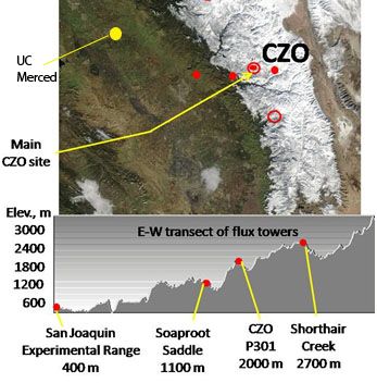
San Joaquin Experimental Range (210-520 m elevation)
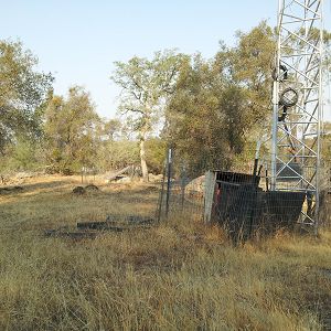
The San Joaquin Experimental Range (SJER) research site is in the oak woodland foothills of the southern Sierra Nevada.
Soaproot Saddle (1000-1500 m elevation)
The Soaproot Saddle site is located within Ponderosa Pine forest at 1100 meters in elevation within the Sierra National Forest.
Providence Creek Headwater Catchments (1660 - 2115 m elevation)
4.6 km2,
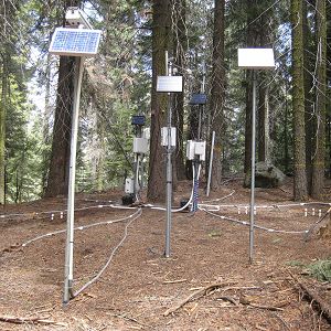
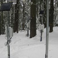
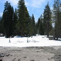
The most intensively studied research area of the Southern Sierra Critical Zone Observatory is the Providence Creek headwaters area, located along a tributary to the North Fork of the Kings River in the Sierra National Forest. Most of the long-term observations by SSCZO are located at this site. The P300 area includes forested hillslopes, some glacial erratics and areas of exposed bedrock, multiple meadows, and creeks draining the catchment.
Providence Creek Subcatchment P301
0.992 km2, 1790-2117 m elevation,
Providence Creek Subcatchment P303
1.323 km2, 1731-2025 m elevation,
Providence Creek Subcatchment P304
0.487 km2, 1768-1983 m elevation,
Short Hair (2670 m elevation)
The Short Hair field area is in the subalpine belt of the Sierra Nevada, located in the Sierra National Forest near Courtright Reservoir.
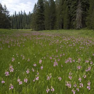
Wolverton Basin (2230 - 2700 m elevation)
8 km2,
Wolverton Basin site in Sequoia National Park comprises meadows and forested mountain slopes.
Other instrumented sites
Other instrumented sites have been established in the Southern Sierra Nevada and are suitable for comparative research, including: Kings River Experimental Watersheds, Sierra Nevada Adaptive Management Project, and the American River Hydrologic Observatory.
Our Field Areas
Our Critical Zone Observatory has developed five long-term critical-zone research sites in areas operated by the USDA Forest Service and National Parks Service. Click on each to learn more.
- San Joaquin Experimental Range (210-520 m)
- Soaproot Saddle, Sierra National Forest (1000-1500 m)
- Providence Creek Headwater Catchments, Sierra National Forest (1660-2115 m)
- Short Hair Creek, Sierra National Forest (2670 m)
- Wolverton Basin, Sequoia-Kings Canyon National Parks (2230-2700 m)
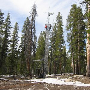
The first four of our these listed sites form an elevational transect that increases in altitude from west to east. The sites span a 2300-m elevation range that captures gradients in climate, regolith, soils, and vegetation. Along this transect, bedrock lithology is generally constant (intrusive felsic plutons). Ecosystems range from low-elevation oak savannah (rain-dominated) to high-elevation subalpine forest (snow-dominated). A series of eddy-covariance gas flux towers are installed at these sites (see below). Other examples of transect-length work include soil and regolith depth, chemistry, and moisture characterizations; vegetation surveys; forest water-balance research; and wind-blown dust geochemistry and microbiology studies.
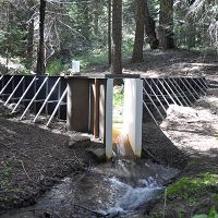
The Providence Creek Headwater Catchments area is the most intenstively monitored and studied area out of our five field sites. Recent research studies at the site have included flux tower installation, several Critical Zone Trees, water balance measurement transect, geoprobe sampling and core characterization, bedrock geochemistry, active and passive geophysical studies, several soil pit characterizations, surface and subsurface hydrologic modeling, wind-blown dust analyses, and isotopic studies of snow, surface water, groundwater, and vegetation water. The Providence Creek Headwater Catchments field area is co-located within the Kings River Experimental Watersheds (KREW) research landscape, operated by the USDA Forest Service Pacific Southwest Research Station. KREW operates stream gaging and sediment basin monitoring throughout the catchment and subcatchments, along with two continuous meteorological stations.
Additional instrumented sites have been established by collaborators in the Southern Sierra and are suitable for comparative research: Kings River Experimental Watersheds (KREW), Sierra Nevada Adaptive Management Project, and American River Hydrologic Observatory. Click here to learn more.
The Sierra Nevada
“Sierra Nevada” is Spanish for “snow-covered mountains”. This mountain range rises from near sea level, in the Central Valley, to over 14,000 feet at the spine of the range, which marks the edge of the Basin and Range Province in eastern California. Much of the ~650 km length and ~100 km width of the mountain range is underlain by plutonic igneous bedrock. Granites and granodiorites that formed approximately 120 to 85 million years ago are especially common near our Critical Zone Observatory’s field sites. However, extrusive, mafic, metamorphic, and sedimentary rocks are also found in the range.
The western slope of the Sierra Nevada is long and gentle compared to the short and steep escarpment found on the east side. This asymmetric shape is thought to be a result of uplift and tilting of the range by compressional and extensional geologic forces over the last several tens of million years. Glaciers have also left their mark, sculpting steep arêtes and deep cirques in the high country over the last two to three million years, during Pleistocene ice advances that were punctuated by ice free periods similar to our modern climate. Meanwhile, rivers have carved V-shaped canyons into lower elevations of the western slope, creating a landscape of broad interfluves and adjacent deep valleys. Our Critical Zone Observatory sites are located in this canyon country of the western slope, below the limits of recent ice advance.
Today the Sierra Nevada is drained by over 20 rivers and supplies about 60 percent of the water used by California’s agriculture, commercial industries, and residents. Annual precipitation in the Sierra today ranges from under one meter in the south to over two meters to the north, with a strong west-east gradient that increases with elevation. Along this altitudinal gradient, precipitation at lower elevations tends to be rain-dominated while higher elevations are snow-dominated. Air temperature also decreases as elevation increases.
Vegetation on the west slope closely reflects the variations in elevation and climate. Rising above agricultural lands of the Central Valley, grasslands merge into the oak woodlands that cover the western foothills in deciduous and live oaks, gray and foothill pines, California buckeyes, grasses, and chaparral shrubs such as ceanothus. These oak woodlands reach up to 600 m elevation in the northern Sierra Nevada and 1500 m in the southern part of the range. A zone of mixed-confer forests is found above this, comprising ponderosa and Jeffrey pine, incense cedar, white fir, sugar pine, and black oak. Mixed-conifer forests are found at elevations up to 2100-2700 m across the Sierra. Forests transition to lodgepole pine and red fir above this, with subalpine vegetation at the highest elevations.
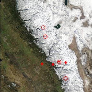
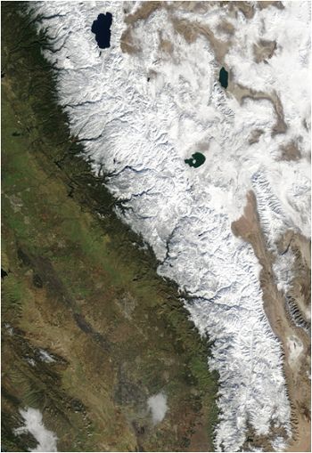
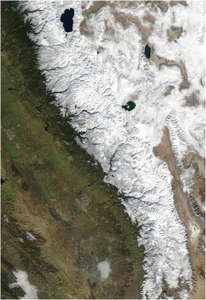
MODIS image of the Sierra Nevada near peak snowpack, from its southern end to Lake Tahoe.
Explore Further
