Conceptual Model
The working draft of the Southern Sierra Conceptual Model consists of 4 panels and accompanying text. It involves understanding varaibles along three axes: i) elevation gradient, representing gradients in climate, regolith properties, soils, ecosystems, and associated processes, ii) spatial scales, and iii) temporal scales. The SSCZO team is actively working on this, with emphasis on the main "Conceptual Model" panel..
Conceptual model
Conceptual model diagram
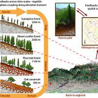
Southern Sierra elevation and climate gradient, with spatial scaling and temporal feedbacks
Processes
Conceptual model processes and implications
Drivers of critical zone development must be understood together to address science questions and understand implications
Spatial scales
Conceptual model—spatial scales
Variables important for spatial scaling of vegetation differences, water cycles and material fluxes
Temporal feedbacks
Feedbacks across time
Variables important for temporal feedbacks of vegetation differences, water cycles and material fluxes
Conceptual model description (see also figures at left)
The Southern Sierra CZO is designed to improve our ability to understand and predict: i) fluxes of water, nutrients and sediments, ii) regolith properties, and iii) ecosystem distribution and function, across a 3000-m elevation gradient extending from the oak savannah that lies just above the agricultural Central Valley, through the mixed conifer forest, to the subalpine forest. These attributes are highly variable in space and time, particularly in complex mountain environments.
Panel 1 -- Conceptual Model. The Southern Sierra CZO is organized along an elevation transect that samples 4 ecosystems, expending from the Oak Savannah in the Sierra fothills to the subalpine forest just below the upper treeline.The 3-D elevation image is overlain with an index of vegetation, with green colors, in mixed conifer forest, being the highest vegetaion densities; and brown or white colors, in the foothills or high Sierra, being the lowest vegetation densities. The most-intensive research catchments and study sites lie in the mixed-conifer forest, as depicted by the catchment-scale map and pore-to-plot diagram. This is the elevation of the all-important rain-snow transition. Below this rain-snow-transition elevation precipitation is rain dominated, and above it snow dominated. With it Mediterranean climate the region receives precipitation mainly in the winter half year. At higher elevations snowpack storage provides an important buffer against water stress, allowing some biotic and abiotic processes to continue through summer.
Spatial scaling along this elevation gradient is also an important organizing principle for the conceptual model. The four catenas on the left illustrate important climate differences along this elevation transect, as reflected in regolith properties, soils and vegetation. CZO research aims to understand and develop a better ability to predict feedbacks across time scales.
Selection of sites along the elevation transect reflects our experimental design; by maximizing variations in climate and vegetation along an altitudinal gradient, and minimizing variations in factors such as topography and parent material within a single Batholith, we seek to hold several of the main state factors roughly constant and thus explore how sharp contrasts in the factors of interest influence critical zone processes. Each site is underlain by granitic bedrock and exhibits a similar range in topographic factors such as slope gradient, aspect, and curvature. Differences in climate across our sites are accompanied by sharp contrasts in biota and regolith properties. Biota differs both in biomass and species composition, ranging from sparsely distributed copses of stunted conifers at subalpine altitudes, to nearly continuous forests of mixed conifers and ponderosa pine at mid elevations, to spares oak-pine woodlands and grasslands in the foothills. Regolith varies both in its thickness and degree of development.
At the highest elevation site (subalpine forest catena), we observe disconnected copses of stunted conifers, which are developed on thin, patchy soils derived from weathering of both underlying bedrock and allocthonous sources (such as dust and glacial drift). Here, seasonally cold temperatures limit net primary productivity and thus evapotranspiration to short growing seasons. We hypothesize that thin, poorly developed regolith reflects either the short annual interaction between vegetation and underlying rock, an incomplete recovery from glacial conditions, or a combination of both factors.
In the mixed-conifer forest, stands of trees are fairly continuous and productivity and evapotranspiration are higher than at any other site on our transect. This appears to because of long growing seasons made possible by sustained moisture and modest temperatures at this mid-elevation site. Regolith profiles are generally thick, with high porosity in saprolite near the surface. However, patches of bare rock are common and abundant, spheroidally weathered corestones litter the surface and complicate near surface geophysical interpretations of subsurface weathering in saprolite. We hypothesize that the occurrence of patches of bare rock may reflect intrinsic contrasts in the weathering susceptibility or nutrient content among the different plutons that underlie the forest at these elevations.
Ponderosa pine forest or Ponderosa pine/oak forest
Oak/Pine woodland or Oak/Pine savanna
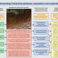
Panel 2 -- Processes and Implicaions. This figure introduces the conceptual model in words, identifying drivers of critical zone processes, overarching questions, implications for how critical zone properties and processes control societally important attributes, and the implications for ecosystem services and sustainability of teh critical zone for supporting life.
The framework outlined in the two matrices that follow provides a conceptual context for our measurements and modeling, which we use to characterize flux gradients at all scales. It also helps us explore cross-scale and cross-process interactions, such as whether differences in bedrock geochemistry determine whether soil is present or absent, thus influencing ET patterns at watershed scales. If this is the case bedrock geochemistry may ultimately regulate the sensitivity of watershed ET to climate change, with implications for predicting stream flow in the future.
We note that the ecologic, climatic and geologic factors in the matrices below influence the fluxes and stores of material, water, and energy and their gradients across landscapes or plots and how those gradients change through time. The dominant control (e.g., geologic versus climatic) however may be different for different fluxes and stores. We also distinguish between water fluxes associated with the near surface (rooting zone to atmosphere) and deeper groundwater fluxes.
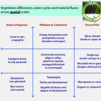
Panel 3 -- Spatial scales. Gradients in fluxes such evapotranspiration (ET), net primary productivity (NPP), nitrification, runoff production, streamflow and sediment transport) occur at multiple spatial scales across regions, hillslopes, and plots. For example, across a region, spring runoff production may vary in consistent ways from high-elevation, snow-dominated locations to low-elevation, rain-dominated locations. At plot scales, runoff production may differ under canopy versus in the open. Observable flux gradients at each scale reflect driving mechanisms, including climatic, ecologic, and geologic processes. The relative importance of these processes varies across spatial scales and also changes with time. In the matrix above, we summarize our conceptual model of the climatic, ecologic and geologic factors that drive gradients in moisture and material fluxes at different scales. Each column represents a spatial scale and each row describes relevant climatic, ecologic, and geologic factors that influence spatial gradients across each scale. For example, regional gradients in moisture fluxes determine whether precipitation is dominated by rain or snow, whether vegetative cover is dominated by grassland or forest, whether the landscape was glaciated or not in the past, and also conditions that dominate today for soil development.
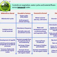
Panel 4 -- Temporal feedbacks. Regolith and biota respond dynamically to critical zone processes. Hence it’s also crucial to consider how flux gradients at respond to changes is underlying climatic, ecologic, and geologic factors through time. In the above matrix, we summarize our conceptual model of these relationships for temporal scales ranging from the glacial timescales of Milankovitch cycles to the instantaneous timescales of the movement of sediment during individual storms.
1
2
3
4
Explore Further
