INFRASTRUCTURE
Observatories, facilities, equipment, personnel...
Nine US observatories - from Puerto Rico to California.
Existing and new resources - Sensor and communication networks, eddy flux towers, boreholes, gauges and much more (some previously built by LTER, Forest Service, et al.)
Community of researchers - Collaborative teams work at the same field sites and encourage other scientists to take advantage of the CZO infrastructure.
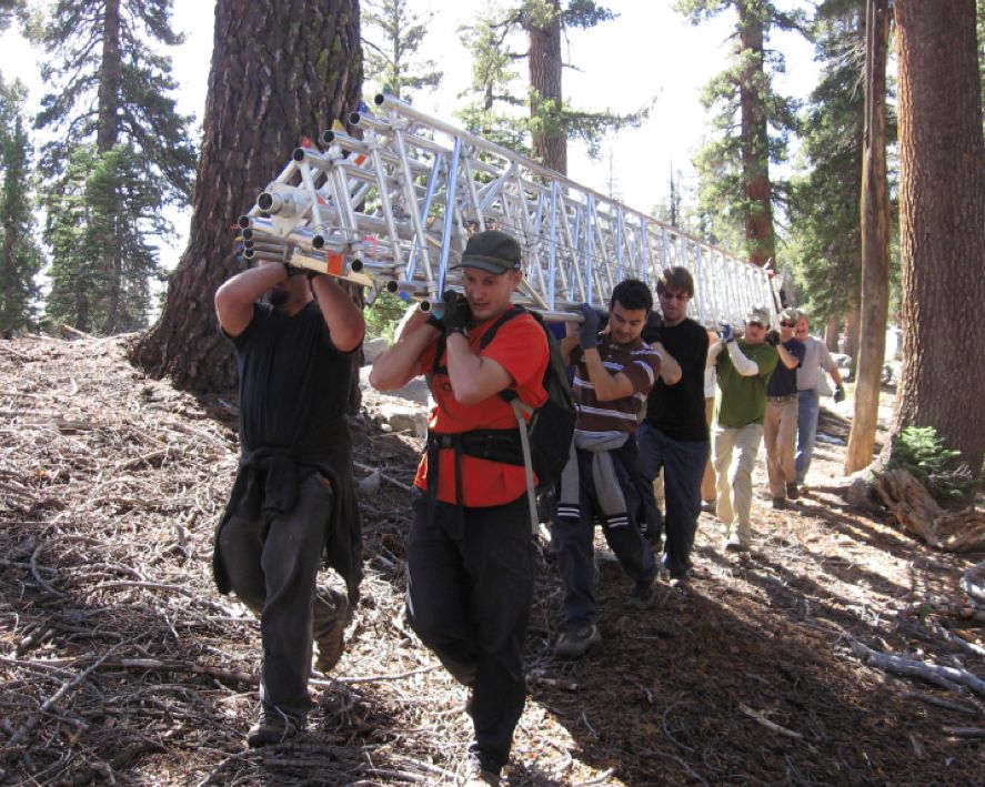
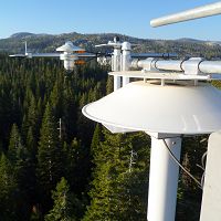
A large field crew begins the process of hauling and constructing a flux tower for the Southern Sierra CZO. Image: Southern Sierra CZO.
Infrastructure Overview
The National CZO Program is centered on nine observatories located in differing climatic and physiographic environments, from California to Puerto Rico. Each observatory is an environmental laboratory studying the chemical, physical and biological processes that shape Earth's surface on short-to-long time scales. Support is provided by the US National Science Foundation (NSF), Geoscience Directorate, Earth Science Division. An additional observatory, Christina CZO, is no longer funded by NSF. Find a summary of CZO site characteristics in the CZO Attributes Table (PDF).
A common approach
Each CZO is working toward a common infrasructure while establishing additional resources that advance their unique strengths.
Partnership
Ongoing collaborations exist with agencies and institutions that have either previously established infrastructure or are cost sharing new infrastructure. New additional partner institutions are encouraged.
Individual or groups of researchers from outside the formal CZO program are encouraged to take avantage of the available infrastructure and data.
Infrastructure News
FEATURED
More news about SSCZO on Center for Ecosystem Climate Solutions
24 Nov 2020 (Sierra) - More news about SSCZO on Center for Ecosystem Climate Solutions, which grew out of the SSCZO, also on Sustainable California
FEATURED
CZ colleagues: Please contact us about proposals for NSF’s CZ Collaborative Network, due 02 Dec 2019
08 Jul 2019 (National, Boulder, Calhoun, Catalina-Jemez, Christina, Eel, IML, Luquillo, Reynolds, Shale Hills, Sierra) - CZO will end Nov 2020, succeeded by the “CZ Collaborative Network”. Let’s explore how the CZ community can build upon the CZOs via new NSF proposals.
FEATURED
Calhoun CZO featured in Duke Magazine
14 Nov 2018 (Calhoun) - How critical zone science unearths secrets: The new cross-disciplinary field of study concerns itself with the living skin of the Earth.
Multiple postdoc and grad student opportunities at UC Merced
12 Sep 2018 (Sierra) - Two postdoctoral scholar positions and multiple MS or PhD research assistantships are currently available at the University of California, Merced....
Research Program Update: September 2018
07 Sep 2018 (Sierra) - Recent activities and findings, funding opportunities, upcoming events, and other updates
Observatories:
Boulder Creek CZO
Colorado
"We study how erosion and weathering control Critical Zone architecture and evolution, concentrating on slope, climate, ecosystems, and rock properties."
Our CZO spans from the Continental Divide (4120 m) in the Front Range of the Rockies to the western edge of the Plains (1480 m). Our research takes advantage of large differences in elevation, climate, geologic history, and weathering regime.
Bounding lat,long:
NW 40.158241, -105.700648; SE 39.847222, -105.002685
Approx center point lat,long:
39.977774, -105.356698
Calhoun CZO
South Carolina
"At the Calhoun, does reforestation of degraded landscapes mask or restore fundamental alterations in CZ hydrology, geomorphology, biology, and biogeochemistry?"
The Calhoun CZO is located in a region with an environmental history that involves some of the most serious agricultural land and water degradation in N America 5 themes:Ecohydrological Recovery; Biogeochemical Decoupling; Erosion-induced Carbon Dynamics; Human-CZ Interactions; Dynamic Persistence of Alternative States
Bounding lat,long:
NW 34.662333, -81.782834; SE 34.544231, -81.649356
Approx center point lat,long:
34.6035, -81.7160
[Christina CZO is no longer active]
Christina River Basin CZO
Delaware/Pennsylvania
"We integrate knowledge of water, mineral and carbon cycles to quantify human impact on Critical Zone carbon sequestration - from soils to sea."
Our CZO is located in the Piedmont and Atlantic Coastal Plain which provides drinking water to a million people in Delaware and Pennsylvania. Our research focusses on water, carbon and mineral fluxes (temporal and spatial integration), including human impacts.
Bounding lat,long:
NW 40.16, -76.3; SE 39.4, -75.0
Approx center point lat,long:
39.698520, -75.626309
Eel River CZO
California
"Exploring how the critical zone will mediate watershed currencies and ecosystem response in a changing environment."
Bounding lat,long:
NW 40.7263, -124.3490; SE 39.2406, -122.6680
Approx center point lat,long:
39.718588, -123.652794
Intensively Managed Landscapes CZO
Illinois/Iowa/Minnesota
"The Intensively Managed Landsapes CZO works to understand how land-use changes affect the long-term resilience of the critical zone."
Bounding lat,long:
NW 46.352885, -97.363941; SE 39.611674, -88.142584
Approx center point lat,long:
39.98731004722222, -88.66616; 41.72710555555556, -91.77335833333333; 44.1677, -94.0034
Secondary Bounding lat,long:
Minnesota River: NW 46.3530, -97.3517
; SE 43.2307, -93.0885Clear Creek: NW 41.7680, -92.0185; SE 41.6530, -91.5615Sangamon: NW 40.5670, -89.5405; SE 39.6110, -88.1425
Santa Catalina Mountains & Jemez River Basin CZO
Arizona/New Mexico
"We focus on measuring geomorphic, hydrologic, and biogeochemical interactions that drive theory and modeling of critical zone evolution."
Our CZO comprises elevation (climate) gradients on rhyolite, granite and schist in northern New Mexico and Southern Arizona. Our research is especially pertinent to climate variations of arid and semi-arid systems.
Bounding lat,long:
NW 36.018774, -110.847624; SE 32.414320, -106.389630
Approx center point lat,long:
32.427379, -110.757822; 35.889167, -106.532206
Secondary Bounding lat,long:
Catalina: NW 32.5630, -100.8480; SE 32.4140, -100.7240Jemez: NW 36.0188, -106.6724; SE 35.7826, -106.3895
Luquillo CZO
Puerto Rico
"We study how Critical Zone processes and water balances differ in landscapes with contrasting bedrock but similar climatic and environmental histories."
Our CZO is located in a forested, mountainous, and wet region of northeastern Puerto Rico. Our research compares two adjacent watersheds, which are underlain by differing bedrock types and exhibit differing weathering characteristics,
Bounding lat,long:
NW 18.410405, -65.861106; SE 18.187889, -65.669475
Approx center point lat,long:
18.279715, -65.763837
Reynolds Creek CZO
Idaho
"The Reynolds Creek CZO will address the grand challenges of improving prediction of soil carbon (C) storage and flux from the pedon to landscape scale"
Soil carbon is the largest terrestrial C store but remains a large source of uncertainty in global climate models due to scaling and process understanding. Reynolds Creek CZO is focused on the quantification of soil carbon and the critical zone processes governing it.
Bounding lat,long:
NW 43.312983, -116.859446; SE 43.060888, -116.688138
Approx center point lat,long:
43.205809, -116.749823
Susquehanna Shale Hills CZO
Pennsylvania
"We emphasize quantitative prediction of Critical Zone creation and structure, focusing on pathways and rates of water, solutes, and sediments"
Our CZO is a forested, first-order catchment on shale bedrock in a temperate climate. Our research promotes understanding of how the forested catchment evolves over multiple timescales ranging from the meteorological to the geological.
Bounding lat,long:
NW 40.731944, -78.073333; SE 40.589444, -77.846759
Approx center point lat,long:
40.65, -77.95
Southern Sierra CZO
California
"We investigate the critical zone across a mountainous elevation gradient, focusing on water balance, nutrient cycling, and weathering processes."
SSCZO is based in the southwestern Sierra Nevada with sites ranging from oak savannah to subalpine forest, crossing the rain-snow transition zone. Research at these sites focuses on water, nutrient, and soil fluxes; and landscape and climate changes cross space and time.
Bounding lat,long:
NW 37.739566, -120.061087; SE 36.172095, -118.333915
Approx center point lat,long:
37.056960, -119.195966
Explore Further
