INFRASTRUCTURE

The Critical Zone Observatory for Intensively Managed Landscapes (IML-CZO) infrastructure consists of three well-instrumented field sites with excellent resources for carrrying out field research and associated data analysis and modeling. The Midwest, which is largely devoted to intensive row-crop agriculture and growing urban areas, features a type of landscape that has not, until now, been examined within the context of a CZO. In this environment, we have the perfect opportunity to study the ways that intensive agriculture, artificial drainage, wetland loss, and urbanization in Intensively Managed Landscapes (IMLs) of the U.S. Midwest have dramatically altered the Critical Zone.
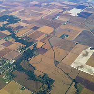
The IML-CZO's network of three core sites includes the Upper Sangamon River Basin in Illinois, the Clear Creek Watershed in Iowa, and the Minnesota River Basin in Minnesota. These sites represent a range of landscape variations found throughout the glaciated Midwest and provide an opportunity to advance our understanding of the CZO in this important region.
Intensively managed landscapes encompass agricultural, urban, and natural environments where human modifications of the landscapes intersect with the natural legacies of the land.
The three field areas that comprise the main infrastructure of the IML-CZO present variations on themes familiar throughout the Midwest: widespread land use change, where annual row crop agriculture now covers a landscape once dominated by prairie and savannah; tile drain installation; substantial fluvial drainage network modification; extensive fertilization; and increased urbanization. These field areas represent a broad range of physiographic variations found throughout the glaciated Midwest and thereby provide an opportunity to advance understanding of the critical zone in this region. By creating this network of comparable sites, the IML-CZO will not only integrate with existing CZO measurement infrastructure, but also develop and test innovative measurement techniques for quantifying CZ processes and the key-state variables identified per theme.
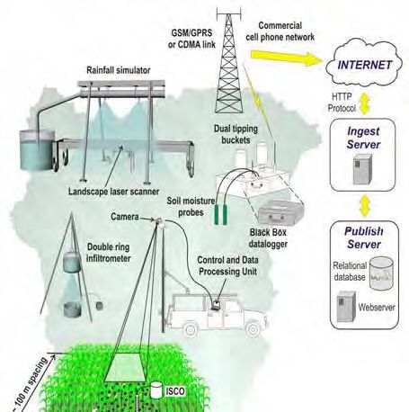
The IML-CZO team makes use of infrastructure that includes a variety of state-of-the-science technology:
-
In research examining timescale process, we capture glacial legacy effects using Ground Penetrating Radar (GPR), coupled with 137Cs and 210Pb dating of select cores. Also, we will establish 3D reconstruction of baseline conditions using four ground-based LiDAR, complemented by seasonal flyovers of small unmanned aerial vehicles.
Conceptual model of an experimental farm with mobile sensor platform to support experiments at the activity centers (Papanicolaou group).
- In the IML-CZO's study of the short- and long-term dynamics of soil organic matter, we will employ ground-based platforms with high-resolution smart sensors, Visible Near InfraRed Spectroscopy (VNIR) for quantifying SOM in-situ, and embedded Radio Frequency IDs (RFIDs) in corn residue and soil aggregates to identify transport pathways. Laboratory characterization of SOM components using Fourier Transform InfraRed Spectroscopy (FTIR) to develop functionalities between SOM fate and clay content provides unique information about SOM provenance in terms of soil stratigraphy and decomposition.
- In our study of coupled surface water-groundwater hydrology and biogeochemistry, we will use isotopic ratios of 15N/14N and 18O/16O that are indicative of suboxic conditions or the bypassing of suboxic zones to differentiate spatiotemporal dynamics of tile vs. non-tile flow in combination with radiocarbon (14C) contents of DOC to quantify the relative importance of surface and subsurface flows.
- The IML-CZO's study of water, soil, sediment, and landscape connectivity couples radionuclide fingerprinting techniques with infrared sensors to perform sediment budget studies and develop sediment rating curves, while partitioning the soil/sediment sources with an unmixing model for assessing how channelization and cultivation have sculpted the landscape.
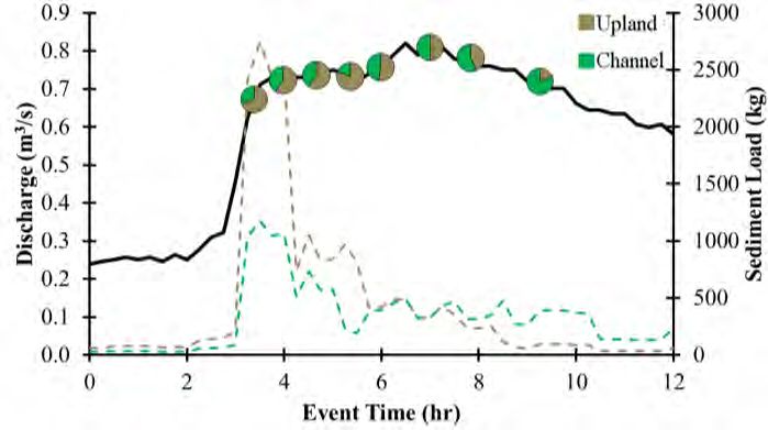
Event-based sediment load partitioning into upland (brown) and channel (green) source materials in Clear Creek using radioisotopes. The relative partitioning is seen with the pies, while the dashed lines are the different sediment loads. The black line is discharge (Wilson et al., 2012)
Conceptual model of an experimental farm with mobile sensor platform to support experiments at the activity centers (Papanicolaou group).
Event-based sediment load partitioning into upland (brown) and channel (green) source materials in Clear Creek using radioisotopes. The relative partitioning is seen with the pies, while the dashed lines are the different sediment loads. The black line is discharge (Wilson et al., 2012)
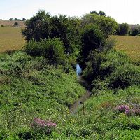
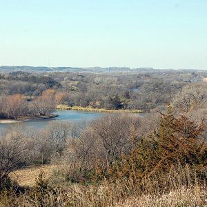
The Clear Creek Basin is a tributary of the Iowa River, draining a 270 km area. The watershed is located in a region with the highest erosion rate in the nation.
Infrastructure News
FEATURED
CZ colleagues: Please contact us about proposals for NSF’s CZ Collaborative Network, due 02 Dec 2019
08 Jul 2019 - CZO will end Nov 2020, succeeded by the “CZ Collaborative Network”. Let’s explore how the CZ community can build upon the CZOs via new NSF proposals.
FEATURED
Urban Sewers Evolve Similarly to River Networks
10 Jan 2018 - Like river systems, engineered drainage networks become increasingly fractal as they grow.
FEATURED
Video: Critical Zone Observatories help U.S. plan for the future
21 Mar 2016 - The short video features the Intensely Managed Landscapes Critical Zone Observatory (IML-CZO) with commentary from IML Co-Director Praveen Kumar.
Water Resources Research Special Collection: Concentration-discharge relations in the critical zone
30 Oct 2017 - Water Resources Research published a new special collection in September 2017 featuring concentration-discharge research from multiple CZOs.
2017 CZO Webinar Series: Critical Zone and Society
06 Apr 2017 - 2017 CZO Webinar Series: Critical Zone and Society.
EOS: Taking the Pulse of the Earth’s Surface Systems
04 Dec 2015 - Taking the Pulse of the Earth's Surface Systems In September of 2014, Laurel Larsen (UC Berkley), Elizabeth Hajek (Penn State), and others...
Using a CZO network to explore the architecture, dynamics and evolution of the Critical Zone
03 Nov 2014 - The US CZO National Office has organized a webinar on December 8, 2014 at 11AM - 12:30 PM ET.
2014 CZOData Cyber-Seminar Spring Series
06 Mar 2014 - Presentations describing the Integrated CZO Data system and how to use it; for interested CZO investigators, students & staff.
Field Areas:
Sangamon River Basin
3,690 km2, 180-291 m elevation, 11 °C, 1000 mm/yr
The Sangamon River Basin includes a broad range of variations typical of the glaciated Midwest, which offer an opportunity to better understand the critical zone in this region. The basin is characterized by low-relief landscapes with poorly drained soils. The hydrological and biogeochemical cycles are strongly affected by freeze–thaw cycles and artificial drainage systems. The landscape is covered with patchy, thin loess (<1.5 m). This basin has a poorly integrated, natural drainage network with extensive areas of poorly drained soils. Weathering profiles are relatively thin and usually grade to unweathered fine-grained glacial till within 5 m of the land surface. Soil patterns generally reflect glacial depositional patterns, except where modified by stream processes in valleys.
Clear Creek Watershed
270 km2, 197-248 m elevation, 9 °C, 889 mm/yr
The Clear Creek, Iowa, watershed covers approximately 270 km2 in East Central Iowa and joins the Iowa River in Coralville, Iowa. Clear Creek is representative of most U.S. Midwestern watersheds with regards to land use (predominantly agricultural), soil type/order (Alfisols and Mollisols), and climate (humid-continental). The combination of extensive agricultural activities, increased urbanization, highly erodible soils, and a humid climate on the steep slopes within the watershed have influenced the erosion processes in the watershed.
Minnesota River Basin
44,000 km2, 210-294 m elevation, 5 °C, 747 mm/yr
The Minnesota River flows more than 335 miles from its source near the Minnesota-South Dakota border to its confluence with the Mississippi River at Minneapolis/St. Paul. It winds through diverse landscapes and drains nearly 20 percent of Minnesota (16,770 square miles total, 14,840 in Minnesota). Agriculture, primarily corn and soybean production, accounts for the majority of the basin’s land use. As the river enters the Twin Cities Metropolitan area, the basin is characterized by densely populated urban landscapes. The Minnesota River has been cited as one of the most polluted rivers in the state and the nation. In 2008, it was listed on American Rivers top 10 most endangered rivers in the United States. It is the focus of a major restoration effort by local, state, and federal agencies, as well as citizen and nonprofit groups.
Explore Further
