Observatories
A Critical Zone Observatory is an environmental laboratory, focused on the interconnected chemical, physical and biological processes shaping Earth's surface.
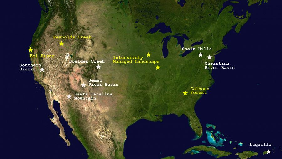
Our nine observatories span a range of climatic, ecologic, geologic, and physiographic environments, from California to Puerto Rico.
Each CZO is working toward a common set of resources, which will enable us to compare whole-watershed Carbon, energy and mass balances across a variety of settings.
NSF's Cheryl Dybas has completed a series of articles describing research at many of the CZOs. Read her articles and download a copy of a report entitled "Discoveries in the Critical Zone: Where Life meets Rock".
Ten US Critical zone Observatories span a wide range of environments and histories.
Boulder Creek CZO
Colorado
"We study how erosion and weathering control Critical Zone architecture and evolution, concentrating on slope, climate, ecosystems, and rock properties."
- What is the legacy of climate and geologic history in critical zone architecture?
- How are the dynamics of key interfaces within critical zone governed?
- What are the feedbacks between hydrologic and ecological processes and critical zone evolution?
- How do landscape position, slope aspect, microclimate and rock properties control the evolution of the critical zone?
Our CZO spans from the Continental Divide (4120 m) in the Front Range of the Rockies to the western edge of the Plains (1480 m). Our research takes advantage of large differences in elevation, climate, geologic history, and weathering regime.
Bounding lat,long:
NW 40.158241, -105.700648; SE 39.847222, -105.002685
Approx center point lat,long:
39.977774, -105.356698
Calhoun CZO
South Carolina
"At the Calhoun, does reforestation of degraded landscapes mask or restore fundamental alterations in CZ hydrology, geomorphology, biology, and biogeochemistry?"
- Does land degradation decouple upper and lower CZ systems, disrupting macroporosity networks that are conduits for gases and water?
- How rapidly can re-forestation recover CZ porosity and re-network the CZ into an integrated system?
- How has historic erosion redistributed and altered organic carbon dynamics on both uplands and in anoxic alluvium filled with historic sediment?
- Can human-forced CZs enter new steady states, complete with positive feedbacks and attractors that resist recovery of previous states?
The Calhoun CZO is located in a region with an environmental history that involves some of the most serious agricultural land and water degradation in N America 5 themes:Ecohydrological Recovery; Biogeochemical Decoupling; Erosion-induced Carbon Dynamics; Human-CZ Interactions; Dynamic Persistence of Alternative States
Bounding lat,long:
NW 34.662333, -81.782834; SE 34.544231, -81.649356
Approx center point lat,long:
34.6035, -81.7160
[Christina CZO is no longer active]
Christina River Basin CZO
Delaware/Pennsylvania
"We integrate knowledge of water, mineral and carbon cycles to quantify human impact on Critical Zone carbon sequestration - from soils to sea."
- Are mineral and carbon mixing processes rate-limiting to watershed-scale carbon sequestration, chemical weathering and soil production?
- Do humans accelerate carbon-mineral mixing rates, and is this significant to local, regional and global budgets?
Our CZO is located in the Piedmont and Atlantic Coastal Plain which provides drinking water to a million people in Delaware and Pennsylvania. Our research focusses on water, carbon and mineral fluxes (temporal and spatial integration), including human impacts.
Bounding lat,long:
NW 40.16, -76.3; SE 39.4, -75.0
Approx center point lat,long:
39.698520, -75.626309
Eel River CZO
California
"Exploring how the critical zone will mediate watershed currencies and ecosystem response in a changing environment."
- Does lithology control rock moisture availability to plants and therefore overall resilience of vegetation to climate change in seasonally dry environments?
- How are solute and gas effluents from hillslopes influenced by biota in changing moisture regimes?
- What controls the spatial extent of wetted channels in the channel networks of seasonally dry environments?
- Will changes in critical zone currencies induced by climate or land use change lead to threshold-type switches in river and coastal ecosystems?
Bounding lat,long:
NW 40.7263, -124.3490; SE 39.2406, -122.6680
Approx center point lat,long:
39.718588, -123.652794
Intensively Managed Landscapes CZO
Illinois/Iowa/Minnesota
"The Intensively Managed Landsapes CZO works to understand how land-use changes affect the long-term resilience of the critical zone."
- How does the coupled interaction of geologic materials, landscape form, and the soil continuum respond to climate, vegetation, and human activities in the critical zone?
- What is the dynamic relation between active and stabilized forms of SOM in IMLs and how does that relationship vary in activity centers and activity intervals? What are their effects on biotic and abiotic activities as they relate to SOM storage?
- How does the coupled interaction of surface water and groundwater control fluxes of water and solutes within the critical zone? How do the signatures of key materials that are exported (e.g., SOM and DOC) relate to those stored in the landscape?
- How are the sources, fluxes, and sinks of sediment in IMLs distributed in space and time? How do geomorphic, biogeochemical, hydrologic, and human processes interact with sediment production, transfer, and storage rates?
Bounding lat,long:
NW 46.352885, -97.363941; SE 39.611674, -88.142584
Approx center point lat,long:
39.98731004722222, -88.66616; 41.72710555555556, -91.77335833333333; 44.1677, -94.0034
Secondary Bounding lat,long:
Minnesota River: NW 46.3530, -97.3517
; SE 43.2307, -93.0885Clear Creek: NW 41.7680, -92.0185; SE 41.6530, -91.5615Sangamon: NW 40.5670, -89.5405; SE 39.6110, -88.1425
Santa Catalina Mountains & Jemez River Basin CZO
Arizona/New Mexico
"We focus on measuring geomorphic, hydrologic, and biogeochemical interactions that drive theory and modeling of critical zone evolution."
- How does variability in energy input and related mass flux influence critical zone structure and function?
- How do feedbacks between critical zone structure and the cycling of water and carbon alter short-term hydrologic response and long-term landscape evolution?
Our CZO comprises elevation (climate) gradients on rhyolite, granite and schist in northern New Mexico and Southern Arizona. Our research is especially pertinent to climate variations of arid and semi-arid systems.
Bounding lat,long:
NW 36.018774, -110.847624; SE 32.414320, -106.389630
Approx center point lat,long:
32.427379, -110.757822; 35.889167, -106.532206
Secondary Bounding lat,long:
Catalina: NW 32.5630, -100.8480; SE 32.4140, -100.7240Jemez: NW 36.0188, -106.6724; SE 35.7826, -106.3895
Luquillo CZO
Puerto Rico
"We study how Critical Zone processes and water balances differ in landscapes with contrasting bedrock but similar climatic and environmental histories."
- How does saprolite advance vary with regolith thickness and landscape position?
- How are soil carbon, surface redox, and plant nutrient cycling affected by bedrock lithology, landscape position, and climate?
- How does bedrock lithology influence delivery of sediment, water and solutes across the landscapes?
- How do riparian zones and the stratigraphy of coastal sediments vary with lithology, climate, and basin size?
Our CZO is located in a forested, mountainous, and wet region of northeastern Puerto Rico. Our research compares two adjacent watersheds, which are underlain by differing bedrock types and exhibit differing weathering characteristics,
Bounding lat,long:
NW 18.410405, -65.861106; SE 18.187889, -65.669475
Approx center point lat,long:
18.279715, -65.763837
Reynolds Creek CZO
Idaho
"The Reynolds Creek CZO will address the grand challenges of improving prediction of soil carbon (C) storage and flux from the pedon to landscape scale"
- How do climate, vegetation, topography, and lithology and regolith properties control and modulate the distribution of soil carbon?
- How do landscape patterns of climate, regolith, and vegetation control soil moisture, evapotranspiration, and streamflow and losses of C as gas and stream export? How do these patterns control and modulate C gains?
- How do land management practices such as prescribed fire and grazing affect carbon storage and the processes governing it?
- How might the distribution of inorganic and organic carbon change with a changing climate and management actions?
- What are the characteristic scales of spatial and temporal variability of soil carbon and what are the hydrologic, geomorphic, and ecosystem variables that correlate with that scale?
Soil carbon is the largest terrestrial C store but remains a large source of uncertainty in global climate models due to scaling and process understanding. Reynolds Creek CZO is focused on the quantification of soil carbon and the critical zone processes governing it.
Bounding lat,long:
NW 43.312983, -116.859446; SE 43.060888, -116.688138
Approx center point lat,long:
43.205809, -116.749823
Susquehanna Shale Hills CZO
Pennsylvania
"We emphasize quantitative prediction of Critical Zone creation and structure, focusing on pathways and rates of water, solutes, and sediments"
- How does water sculpt a landscape on shale bedrock?
- What controls the hydrologic and elemental budgets of the catchment?
- What are the rates and mechanisms of important hydrological, ecological, and geochemical processes?
Our CZO is a forested, first-order catchment on shale bedrock in a temperate climate. Our research promotes understanding of how the forested catchment evolves over multiple timescales ranging from the meteorological to the geological.
Bounding lat,long:
NW 40.731944, -78.073333; SE 40.589444, -77.846759
Approx center point lat,long:
40.65, -77.95
Southern Sierra CZO
California
"We investigate the critical zone across a mountainous elevation gradient, focusing on water balance, nutrient cycling, and weathering processes."
- How do regolith, or weathered bedrock, properties and soil formation processes vary over 10-m to 100-km scales?
- How do physics, chemistry, and biology interact to influence critical zone function over instantaneous to decadal timescales?
- How quickly do regolith properties change in response to longer-term climactic and shorter-term biologic processes?
- How do regolith development and properties control, limit or regulate the effects of climate change and forest management, or of hydrologic, biogeochemical and ecologic disturbances?
- What measurements of the critical zone can best advance knowledge of the critical zone, using cutting edge technology and a range of spatial and temporal scales?
SSCZO is based in the southwestern Sierra Nevada with sites ranging from oak savannah to subalpine forest, crossing the rain-snow transition zone. Research at these sites focuses on water, nutrient, and soil fluxes; and landscape and climate changes cross space and time.
Bounding lat,long:
NW 37.739566, -120.061087; SE 36.172095, -118.333915
Approx center point lat,long:
37.056960, -119.195966
What is a CZO?
A Critical Zone Observatory is an environmental laboratory, a platform for research, that functions at the catchment/watershed scale focused on the interconnected chemical, physical and biological processes shaping Earth's surface.
Find a summary of CZO site characteristics in the
CZO Attributes Table (PDF).
Each Critical Zone Observatory works on shared CZO goals but also focuses on aspects of Critical Zone science that fit the strengths of its investigators and its environmental setting. Each CZO consists of field sites within a watershed. The sites are instrumented for a variety of hydrogeochemical measurements as well as sampled for soil, canopy and bedrock materials.
Each CZO is run by a team of cross-disciplinary scientists who have expertise in fields including hydrology, geochemistry, geomorphology, pedology, ecology and climatology. Participants also include faculty, staff, postdocs, graduate and undergraduate students, and interested members of the general public.
The research at each CZO includes field and theoretical approaches, including modeling studies. Each CZO also emphasizes education and outreach, including students from K-12 to undergraduate and graduate levels.
Each CZO is working toward a common infrastructure while also establishing additional resources that advance their unique strengths. All are supported by the US National Science Foundation (NSF), Geoscience Directorate, Earth Science Division. And all work together with partnering organizations to share existing infrastructure built with other programs.
CZOs provide essential datasets and a coordinated community of researchers that integrate hydrologic, ecological, geochemical, and geomorphic processes from grain-to-watershed scales. CZOs are the lenses through which the rich complexity of interactions between the lithosphere, pedosphere, hydrosphere, biosphere, and atmosphere can be brought into focus. CZOs are poised to reveal how mass and energy fluxes interact with life and rock over geological timescales, for example processes that transform bedrock into soils, and how the same coupled processes enact feedbacks between the Critical Zone and changing climate and land use over timescales of human decision making.
Why nine linked CZOs?
The U.S. National CZO Program is centered on nine observatories located in differing climatic and physiographic environments, from California to Puerto Rico. An additional tenth observatory is inactive and not currently funded by NSF. The CZOs work with their European counterpart observatories funded by the European Commission (see SoilTrEC).
Although funded individually, the U.S. CZOs work together to progress Critical Zone science and maximize their combined resources and potential. More specifically, the U.S. CZOs are working together to help determine how the Critical Zone operates and evolves - including a predictive ability for how it will respond to projected changes in climate and land use. Together, they are building a shared platform for broader research.
The wide range of climates, histories, and environmental settings spanned by the CZOs enable invaluable collaborations and intercomparisons. The CZOs are interlinked on many levels and include shared infrastructure, knowledge, data and meetings.
- Common infrastructure and measurements across CZOs
- Overlapping research agendas
- Each CZO focuses on a specific locality, but aims to produce transferrable results.
Why catchment/watershed scale?
Catchments and river basins represent natural organizing scales for terrestrial water, energy, and weathering cycles, as well as human impacts. Of course, they must be viewed in the larger regional geologic and geomorphic context.
The CZOs focus on whole-watershed energy, carbon and mass balances.
NSF articles on CZO Discoveries
NSF Summary page: CZO Discoveries
Scientists at NSF's network of 10 Critical Zone Observatories (CZOs) are addressing questions about the thin veneer of Earth's surface that extends from the top of the tree canopy to the base of weathered bedrock. The zone is critical because it's where fresh water flows, soil is formed and life flourishes. The critical zone provides most of the ecosystem services on which society depends.
Part 1: Can Marcellus Shale Gas Development and Healthy Waterways Sustainably Coexist?
National Science Foundation Sustainability Research Coordination Network is providing answers
Part 2: A Tree Stands in the Sierra Nevada
A coniferous view of the link between snowmelt and water supplies in the U.S. West
Part 3: Science on the Graveyard Shift
Discovering what gets buried and how
Part 4: High-peak Creeks, Forest Fires and Landscape Erosion: Could They Be Linked?
Colorado's Boulder Creek watershed: Where rushing streams, raging blazes and the Rockies meet
Part 5: El Yunque, Majestic Rocky Icon of Puerto Rico: Impervious to the Ravages of Time?
Anvil-shaped promontory formed inside an ancient supervolcano
Part 6: Earth Week: The Search for White Gold--Snowmelt
Thin snowpack puts ecosystems and water resources in critical condition
Part 7: Trail of Fire Leads to Less Snow, Threatened Water Resources
Scientists study New Mexico's Rabbit Mountain, where forests burned in the 2011 Las Conchas fire
Part 8: Granite bedrock and sequoia forests 'communicate' in the Sierra Nevada
Research reveals the coevolution of life and landscapes
Part 9: On World Water Day, scientists peer into rivers to answer water availability questions
NSF Critical Zone Observatory researchers study California's Eel River for insights into water losses
Part 10: What's good for crops not always good for the environment
Measure of age in soil nitrogen could help precision agriculture
Part 11: NSF-supported scientists to present research results on Earth's critical zone at AGU fall meeting
Topics range from the function of Earth's 'living skin' to interactions between climate and bedrock
Part 12: NSF awards $1.35 million for new institute focused on Earth's critical zone: Where rock meets life
Institute scientists will cross the boundaries of Earth's critical zone from tree canopy to groundwater base
Part 13: NSF awards grants for four new critical zone observatories to study Earth surface processes
Sites are in Southeast Piedmont; Southwest Idaho; Northern California; and Illinois-Iowa-Minnesota
Part 14: Dust contributes valuable nutrients to Sierra Nevada forest ecosystems
New research finding provides insight into role dust may play as ecosystems change
Part 15: Corn better used as food than biofuel, study finds
Scientists obtain comprehensive view of agricultural ecosystems
Part 16: Can an ancient ocean shoreline set the stage for a tropical forest of today?
Researchers at NSF Critical Zone Observatory and Long-Term Ecological Research sites are finding out.
Additional Observatories
Observatories studying the Critical Zone are being built around the Globe. The US NSF CZO Program is collaborating with many of them.
To view some international field sites, see
- CZEN, the Critical Zone Exploration Network
- CZEN Site Seeker
- SoilTrEC, Soil Transformations in European Catchments
- SoilTrEC World Critical Zone Observatories
Explore Further
