Geomorphology Tag
Geomorphology is one of more than 16 discipline tags that we use to categorize and aggregate our interdisciplinary information within and across CZOs. Much of our information has been tagged with 2-3 disciplines.
-
Catalina-Jemez People - Geomorphology
3 People

INVESTIGATOR
.(JavaScript must be enabled to view this email address)
Univ. of Arizona
Dryland Ecohydrology, Vegetation Gradients and Global Change, Tree Die-off

INVESTIGATOR, Lead-PI
.(JavaScript must be enabled to view this email address)
Univ. of Arizona
Hydrology, Geomorphology
INVESTIGATOR
.(JavaScript must be enabled to view this email address)
Environmental Physics and Mineralogy
-
Catalina-Jemez Research Groups - Geomorphology
-
Catalina-Jemez Data - Geomorphology
Betasso - Topographic Carbon Storage, GIS/Map Data, LiDAR, Land Cover (2010)
2 components • Betasso • GIS / Remote Sensing, Biology / Ecology, Geomorphology, Hydrology • Tyson Lee Swetnam; Paul Brooks; Holly Barnard; Adrian Harpold; Erika GalloComo Creek - Topographic Carbon Storage, GIS/Map Data, LiDAR, Land Cover (2010)
2 components • Boulder Creek Watershed • GIS / Remote Sensing, Biology / Ecology, Geomorphology, Hydrology • Tyson Lee Swetnam; Paul Brooks; Holly Barnard; Adrian Harpold; Erika GalloGordon Gulch - Topographic Carbon Storage, GIS/Map Data, LiDAR, Land Cover (2010)
2 components • Gordon Gulch • GIS / Remote Sensing, Biology / Ecology, Geomorphology, Hydrology • Tyson Lee Swetnam; Paul Brooks; Holly Barnard; Adrian Harpold; Erika GalloJemez 2013 Burned ZOB - Soil Geochemistry (2010)
1 components • Jemez 2013 Burned ZOB • Geochemistry / Mineralogy, Soil Science / Pedology, Geomorphology • Craig Rasmussen; Jon ChoroverJemez River Basin - LiDAR - Post-Fire (2012)
2 components • Jemez River Basin • Geomorphology, GIS / Remote Sensing • Jon PelletierJemez River Basin - LiDAR - Terrestrial Laser Scan (2011-2013)
3 components • Jemez River Basin, Jemez 2011 Burned ZOB • GIS / Remote Sensing, Geomorphology • Caitlin Orem; Jon PelletierNational - LiDAR, Land Cover, GIS/Map Data - OpenTopography (2010-2017)
18 components • Boulder Creek Watershed, Eel River Watershed, Jemez River Basin, Reynolds Creek Experimental Watershed, Susquehanna Shale Hills Critical Zone Observatory, Northeastern Puerto Rico and the Luquillo Mountains, Sangamon River Basin, Clear Creek Watershed, Calhoun Critical Zone Observatory, Providence Creek Headwater Catchments (1660 - 2115 m elevation) • Geomorphology, GIS / Remote Sensing, Hydrology, Biology / Ecology • National Center for Airborne Laser Mapping; Boulder Creek Critical Zone Observatory; Calhoun Critical Zone Observatory; University of Arizona; University of California Merced; Valles Caldera National Preserve; Bandelier National Monument; National Park Service; Jemez River Basin and Santa Catalina Mountains Critical Zone Observatory; Luquillo Critical Zone Observatory; Reynolds Creek CZO; Eel River CZO; Shale Hills CZO -
Catalina-Jemez Models - Geomorphology
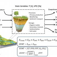
EEMT
Environmental Energy and Mass Transfer
Conceptual framework for CZ structure evolution based on nonequilibrium thermodynamics.
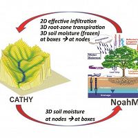
TIMS
Terrestrial Integrated Modeling System
A coupled model of hydrological, microbial, geochemical, geomorphological and ecological processes at the Earth’s land surface.
-
Catalina-Jemez Publications - Geomorphology
2019
Distinct stores and the routing of water in the deep critical zone of a snow-dominated volcanic catchment. White A., Moravec B., McIntosh J., Olshansky Y., Paras B., Sanchez R.A., Ferré T.P.A., Meixner T., and Chorover J. (2019): Hydrology and Earth System Sciences 23(11): 4661-4683
2018
Which way do you lean? Using slope aspect variations to understand Critical Zone processes and feedbacks. Pelletier J. D., Barron‐Gafford G. A., Gutiérrez‐Jurado H., Hinckley E.‐L. S., Istanbulluoglu E., McGuire L. A., Niu G.‐Y., Poulos M. J., Rasmussen C., Richardson P., Swetnam T. L., and Tucker G. E. (2018): Earth Surface Processes and Landforms, 43(5): 1133–1154 Cross-CZO
2017
Reviews and syntheses: on the roles trees play in building and plumbing the critical zone. Brantley, Susan L., David M. Eissenstat, Jill A. Marshall, Sarah E. Godsey, Zsuzsanna Balogh-Brunstad, Diana L. Karwan, Shirley A. Papuga, Joshua Roering, Todd E. Dawson, Jaivime Evaristo, Oliver Chadwick, Jeffrey J. McDonnell, Kathleen C. Weathers (2017): Biogeosciences, 14, 5115-5142 Cross-CZO National
2017
Concentration-Discharge Relations in the Critical Zone: Implications for Resolving Critical Zone Structure, Function and Evolution. Chorover, J., Derry, L. A., McDowell, W. H. (2017): Water Resources Research 53(11): 8654–8659 Cross-CZO National
2017
Regional sensitivities of seasonal snowpack to elevation, aspect, and vegetation cover in western North America. Christopher J. Tennant, Adrian A. Harpold, Kathleen Ann Lohse, Sarah E. Godsey, Benjamin T. Crosby, Laurel G. Larsen, Paul D. Brooks, Robert W. Van Kirk, Nancy F. Glenn (2017): Water Resources Research 53 Cross-CZO National
2017
Asymmetry of weathering-limited hillslopes: the importance of diurnal covariation in solar insolation and temperature. Pelletier J.D. and Swetnam T.L. (2017): Earth Surface Processes and Landforms 42(9): 1408–1418
2017
Coevolution of soil and topography across a semiarid cinder cone chronosequence. Rasmussen C., McGuire L., Dhakal P., Pelletier J.D. (2017): CATENA 156: 338-352
2016
Topographic correlations with soil and regolith thickness from shallow-seismic refraction constraints across upland hillslopes in the Valles Caldera, New Mexico. Olyphant J., Pelletier J.D., and Johnson R. (2016): Earth Surface Processes and Landforms 41(12): 1684–1696
2016
Constraining frequency–magnitude–area relationships for rainfall and flood discharges using radar-derived precipitation estimates: example applications in the Upper and Lower Colorado River basins, USA. Orem C.A. and Pelletier J.D. (2016): Hydrology and Earth System Sciences 20: 4483-4501
2016
The predominance of post-wildfire erosion in the long-term denudation of the Valles Caldera, New Mexico. Orem C.A. and Pelletier J.D. (2016): Journal of Geophysical Research: Earth Surface 121(5): 843–864
2016
The influence of Holocene vegetation changes on topography and erosion rates: a case study at Walnut Gulch Experimental Watershed, Arizona. Pelletier J. D., Nichols M. H., and Nearing M. A. (2016): Earth Surface Dynamics 4: 471-488
2015
Seeking GUTH, the Grand Unified Theory of Hillslopes: Linking weathering, erosion and landscapes. Anderson, SP, Dietrich, WE, Rempe, D, West, N, Brantley, SL, Bacon, AR, Buss, HL, Fisher, BA, Flinchum, B, Holbrook, S, Klos, PZ, Leopold, M, Moon, S, Nielson, T, Pelletier, J, and Terry, N. (2015): EP34A-01 Landscape Evolution from a Critical Zone Science Perspective III, presented at 2015 Fall Meeting, AGU, San Francisco, CA, 14-18 Dec. Cross-CZO
2015
Lithologic Control on Secondary Clay Mineral Formation in the Valles Caldera, New Mexico. Caylor E., Rasmussen C., Dhakal P. (2015): Abstract EP31B-1000 presented at 2015 Fall Meeting, AGU, San Francisco, CA, 14-18 Dec.
2015
Laser vision: lidar as a transformative tool to advance critical zone science. Harpold, A. A., Marshall, J. A., Lyon, S. W., Barnhart, T. B., Fisher, B. A., Donovan, M., Brubaker, K. M., Crosby, C. J., Glenn, N. F., Glennie, C. L., Kirchner, P. B., Lam, N., Mankoff, K. D., McCreight, J. L., Molotch, N. P., Musselman, K. N., Pelletier, J., Russo, T., Sangireddy, H., Sjöberg, Y., Swetnam, T., and West, N. (2015): Hydrol. Earth Syst. Sci., 19, 2881-2897 Cross-CZO National
2015
Chapter 8 – Ecohydrology and the Critical Zone: Processes and Patterns Across Scales. Moore G., McGuire K., Troch P., Barron-Gafford G. (2015): Developments in Earth Surface Processes 19: 239-266
2015
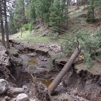
Quantifying the time scale of elevated geomorphic response following wildfires using multi-temporal LiDAR data: An example from the Las Conchas fire, Jemez Mountains, New Mexico. Orem C.A. and Pelletier J.D. (2015): Geomorphology 232: 224–238
2014
Structure and processes controlling resource islands and microtopography on semi-arid hillslopes. Harman, C., Lohse, K.A., Troch, P., and M. Sivapalan (2014): Journal of Geophysical Research Biogeosciences Cross-CZO
2014
A Cross-scale Study of Feldspar Transformation in the Santa Catalina Mountain Critical Zone Observatory. Lybrand R.A. and Rasmussen C (2014): Procedia Earth and Planetary Science 10: 63–68
2014
Controls on the Mean Spacing of Channels on Incised Alluvial Terraces in the Western US. McGuire L. and Pelletier J. (2014): Abstract EP33B-3643 presented at 2014 Fall Meeting, AGU, San Francisco, CA, 15-19 Dec.
2014
Development of topographic asymmetry: Insights from dated cinder cones in the western United States. McGuire L.A., Pelletier J.D., and Roering J.J. (2014): Journal of Geophysical Research 119(8): 1725–1750
2014
The frequency and magnitude of flood discharges and post-wildfire erosion in the southwestern US. Orem C.A. (2014): Disertation in Geosiences. University of Arizona, Tucson, Arizona, 196 pp
2014
Controls on Yardang Morphology: Insights from Field Measurements, Lidar Topographic Analyses, and Numerical Modeling (Invited). Pelletier J. and Kapp P. (2014): Abstract EP51F-04 presented at 2014 Fall Meeting, AGU, San Francisco, CA, 15-19 Dec.
2014
Development of High-Resolution Regolith Thickness and Topographic Datasets for Regional/Global Land-Surface Modeling. Pelletier J., Broxton P., Hazenberg P., Zeng X., Troch P., Niu G-Y., Brunke M., Gochis D. (2014): Abstract H43G-1027 presented at 2014 Fall Meeting, AGU, San Francisco, CA, 15-19 Dec.
2014
How do sediment yields from post-wildfire debris-laden flows depend on terrain slope, soil burn severity class, and drainage basin area? Insights from airborne-lidar change detection. Pelletier J.D. and Orem C.A. (2014): Earth Surface Processes and Landforms 39(13): 1822–1832
2014
Progress on relationships between horizontal and vertical dust flux: Mathematical, empirical and risk-based perspectives. Whicker J.J., Breshears D.D. and Field J.P. (2014): Aeolian Research 14: 105-111
2013
Coevolution of topography, soils, and vegetation in upland landscapes: Using cinder cones to elucidate ecohydrogeomorphic feedback mechanisms . McGuire L., Pelletier J.D., Rasmussen C. (2013): Abstract EP13C-0884 presented at 2013 Fall Meeting, AGU, San Francisco, CA, 9-13 Dec.
2013
Using airborne and terrestrial LiDAR to quantify and monitor post-fire erosion following the Las Conchas fire, Jemez Mountains, New Mexico. Orem C.A. and Pelletier J.D. (2013): Abstract presented at Chapman Conference on Post-wildfire Runoff and Erosion Response, Estes Park, Colorado, 25 - 31 August
2013
A robust, two-parameter method for the extraction of drainage networks from high-resolution Digital Elevation Models (DEMs): Evaluation using synthetic and real-world DEMs. Pelletier J. D. (2013): Water Resources Research 49(1): 75–89
2013
Coevolution of nonlinear trends in vegetation, soils, and topography with elevation and slope aspect: A case study in the sky islands of southern Arizona. Pelletier J.D., Barron-Gafford G.A., Breshears D.D., Brooks P.D., Chorover J., Durcik M., Harman C.J., Huxman T.E., Lohse K.A., Lybrand R., Meixner T., McIntosh J.C., Papuga S.A., Rasmussen C., Schaap M., Swetnam T.L., and Troch P.A. (2013): Journal of Geophysical Research: Earth Surface 118(2): 741-758
2012
Connections between transport in events and transport at landscape-structuring timescales (Invited). Harman C.J., Lohse K.A., Troch P.A., Sivapalan M. (2012): Abstract H52E-04 presented at 2012 Fall Meeting, AGU, San Francisco, Calif., 3-7 Dec (Talk).
2012
Analytic solution for the morphology of a soil-mantled valley undergoing steady headward growth: Validation using case studies in southeastern Arizona. Pelletier J.D. and Perron J.T. (2012): Journal of Geophysical Research, 117: F02018
2011
Co-evolution of Vegetation, Sediment Transport and Infiltration on semi-arid hillslopes . Harman, C.J., Troch, P.A., Lohse, K.A., Sivapalan, M. (2011): AGU Fall Meeting Presentations (Poster) Abstract B33G-0555.
2011
Assessing eolian contributions to soils in the Boulder Creek Catchment, Colorado,. MacCarthy, James A. (2011): Thesis submitted in partial fulfillment of the requirements for the Degree of Bachelor of Arts With Honors in Geosciences(Williams College) Cross-CZO
2011
Calibration and testing of upland hillslope evolution models in a dated landscape: Banco Bonito, New Mexico, USA . Pelletier J.D., McGuire L.A., Ash J.L., Engelder T.M., Hill L.E., Leroy K.W., Orem C.A., Rosenthal W.S. Trees M.A. Rasmussen C., and Chorover J. (2011): Journal of Geophysical Research, 116: F04004,
2011
Domes, Ash and Dust - Controls on soil genesis in a montane catchment of the Valles Caldera, New Mexico. Rasmussen, C., Meding, S.M., Vazquez, A., Chorover, J. (2011): AGU Fall Meeting Presentations (Poster) Abstract EP51B-0845.
2010
Can Landscape Heterogeneity Buffer or Exacerbate Changes in Mountain Hydrology under Different Climatic Conditions?. Broxton, P.D., Troch, P.A., Brooks, P.D. (2010): AGU Fall Meeting (Poster) Abstract H33C-1143.
2010
Biophysical drivers of erosion and aeolian transport in semiarid grasslands: Consequences of prescribed fire, livestock grazing and climate variability. Field, J.P., Breshears, D.D., Whicker, J.J. (2010): AGU Fall Meeting (Invited) Abstract B22B-07.
2010
Transition of spatial controls on distributed soil moisture and runoff simulations at multiple model resolutions . Mahmood T.H., Vivoni E.R. (2010): AGU Fall Meeting (Poster) Abstract H41F-1133.
2010
Coevolution of topography, hydrology, soil development, and vegetation in sky islands of the southwestern United States. Pelletier, J.D., Rasmussen, C., Breshears, D.D., Brooks, P.D., Chorover, J., Huxman, T.E., Lohse, K.A., Meixner, T., McIntosh, J.C., Kurc, S.A., Schaap, M.G., Swetnam, T., Troch, P.A. (2010): AGU Fall Meeting Abstract EP42A-03.
2010
Climate and landscape controls on chemical weathering - regional to pedon-scale analysis. Rasmussen, C., Lybrand, R., Jardine, A.B., Heidbuechel, I., Troch, P.A., Chorover, J. (2010): AGU Fall Meeting (Invited) Abstract EP42A-02.
2010
Environmental Energy and Mass Transfer: Key to Understanding Catchment Evolution. Troch, P.A., Rasmussen, C., Broxton, P.D., Heidbuechel, I. (2010): AGU Fall Meeting (Invited) Abstract H32B-01.
2009
Quantifying the climatic and tectonic controls on hillslope steepness and erosion rates. Pelletier J.D. and Rasmussen C. (2009): Lithosphere 1(2): 73-80
2009
Geomorphically based predictive mapping of soil thickness in upland watersheds. Pelletier J.D. and Rasmussen C. (2009): Water Resources Research 45: W09417
2009
Tectonic and structural control of fluvial channel morphology in metamorphic core complexes: The example of the Catalina-Rincon core complex, Arizona. Pelletier J.D., Engelder T.M., Comeau D., Hudson A., Leclerc M., Youberg A., and Diniega S. (2009): Geosphere 5(4): 363-384
-
Catalina-Jemez News - Geomorphology
2016
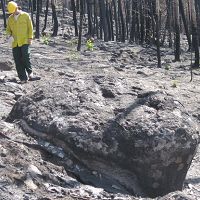
Post-Wildfire Erosion Can Sculpt Forested Mountains
19 Apr 2016 - Researchers from the UA Santa Catalina Mountains & Jemez River Basin Critical Zone Observatory did before-and-after studies of how severe...
2014
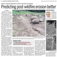
Predicting post-wildfire erosion better
08 Dec 2014 - Jon Pelletier and his graduate student Caitlin Orem's research on the post Las Conchas fire erosion was highlighed in the Arizona Daily Star...
2013
Best student presentation award
16 Sep 2013 - Congratulations to Caitlin Orem for the best student presentation award at the Chapman conference on Post-wildfire Runoff in Estes Park, CO.

Postdoctoral Opportunities
28 Jun 2013 - Postdoctoral Opportunity with the Santa Catalina – Jemez Critical Zone Observatory
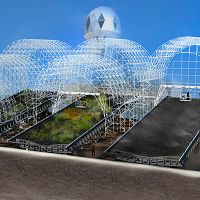
Biosphere 2 Landscape Evolution Observatory
05 Jun 2013 - University of Arizona and Biosphere 2 announce the Landscape Evolution Observatory (LEO), a model CZO under glass.

Opportunity: Vacancy-NSF Section Head, Surface Earth Processes (EAR)
16 May 2013 - Job Title: Section Head, Surface Earth Processes Section Agency: National Science Foundation Job Announcement Number: ...
-
Catalina-Jemez Events - Geomorphology
Dissertation Defense
The Frequency and Magnitude of Flood Discharges and Post-wildfire Erosion in the Southwestern U.S
ENRB 253.SWES Colloquium Series 2013-2014
Collaborative Research Opportunities at the Landscape Evolution Observatory of Biosphere 2
Marley 230.Exploring Sky Islands Lecture Series
Hillslopes and River Channels of the Santa Catalina Mountains: How rock type and climate affects topography in Tucson's Sky Island
Theatre at Flandrau Science Center and Planetarium.
Explore Further
