EEMT
Environmental Energy and Mass Transfer
Conceptual framework for CZ structure evolution based on nonequilibrium thermodynamics.
Model Category: Conceptual
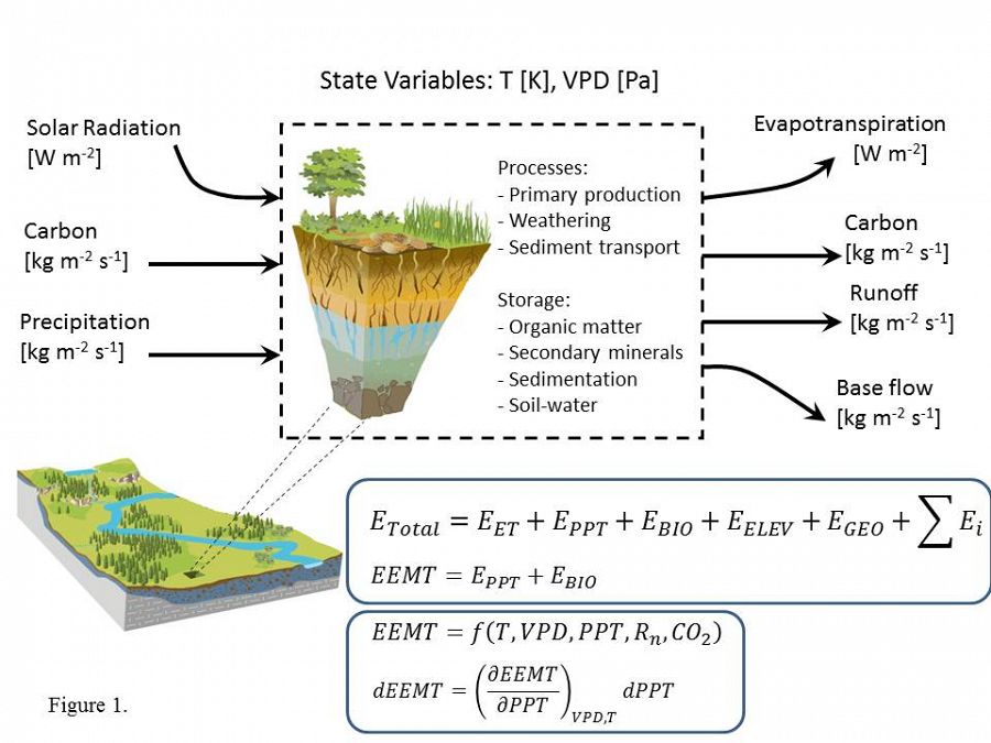
Image: Figure 1. As an open, non-equilibrium system, the CZ receives energy and matter influx that is transmitted along evolving flow paths set up by tectonic/climatic forcing and subjected to internal gradients (Rasmussen et al., 2010). Evolution of internal structure is driven by system entropy dissipation in the form of water, heat and biogeochemical products of CZ erosion and weathering (sediments, solutes, and trace gases).
-

Catalina-Jemez, INVESTIGATOR
Given the open system conceptualization (Figure 1), we postulate that critical zone evolution can be related quantitatively to water and fixed carbon fluxes influent to the CZ as represented by environmental energy and mass transfer (EEMT).
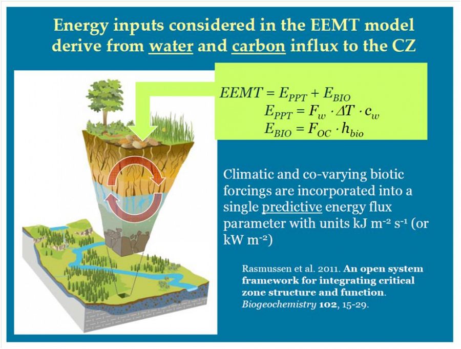
Figure 2. Climatic forcing of CZ evolution is quantified on the basis of effective precipitation (EPPT = FW . CW . ΔT , where FW is water mass flux, CW is water heat capacity, ΔT is Tambient - 273 K) and fixed carbon (EBIO = FOC . hBIO, where FOC is reduced C mass flux and hBIO is the Gibbs energy of biomass C).
EEMT includes effective precipitation (EPPT) and net primary production (EBIO) components (Rasmussen et al., 2010) that can be calculated from meteorological and landform data (e.g., Figure 2) and/or measured from reduced carbon and water fluxes across CZ interfaces.
Calculation of EEMT across the Jemez River Basin and Santa Catalina Mountain CZO surfaces (Figure 3) shows the impacts of elevation and slope aspect on climatic forcing in these “sky islands” of the Southwest. At both locations, precipitation increases and temperature decreases with increasing elevation. These EEMT gradients overlain on granite, schist (SCM) and rhyolite (JRB) lithologies are expected to correlate with CZ structural evolution.

Figure 3. The Jemez River Basin - Santa Catalina Mountains Critical Zone Observatory (JRB-SCM CZO) comprises two research sites - JRB in north central New Mexico and SCM in southern Arizona. Top panels show digital elevation models of SCM and Valles Caldera in JRB. Lower panels show EEMT calculations for annual flux (MJ m-2 yr-1) at 10 m resolution for the SCM (d) and Valles Caldera of JRB. Instrumented sites are outlined.
To model EEMT at the hillslope scale requires downscaling temperature and effective precipitation to sub 10-m pixel resolution in order to account for topographic controls on temperature, evapotranspiration, and water redistribution. EEMT for a given hillslope position depends on aspect variation, local biomass accretion, and direct water inputs including effective precipitation subsidy deriving from topographically controlled redistribution. Topographic wetness index provides a scale-independent measure of potential water subsidy that is incorporated into the EEMT surface calculation for Sabino Canyon Watershed (SCM CZO, Figure 4). In association with its elevation gradient, the Sabino Canyon Watershed extends from Mixed Conifer Forest (where Marshall Gulch site is situated) at high EEMT to Sonoran Desert (similar to where B2 desert site is located) at low EEMT (Figure 4).
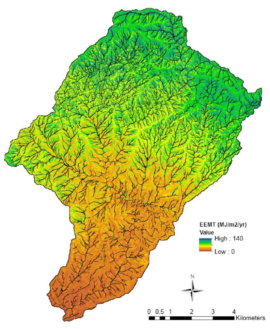
Figure 4. The EEMT surface of the Sabino Canyon Watershed containing Marshall Gulch in the SCM (point based EEMT modeling).
Figure 2. Climatic forcing of CZ evolution is quantified on the basis of effective precipitation (EPPT = FW . CW . ΔT , where FW is water mass flux, CW is water heat capacity, ΔT is Tambient - 273 K) and fixed carbon (EBIO = FOC . hBIO, where FOC is reduced C mass flux and hBIO is the Gibbs energy of biomass C).
Figure 3. The Jemez River Basin - Santa Catalina Mountains Critical Zone Observatory (JRB-SCM CZO) comprises two research sites - JRB in north central New Mexico and SCM in southern Arizona. Top panels show digital elevation models of SCM and Valles Caldera in JRB. Lower panels show EEMT calculations for annual flux (MJ m-2 yr-1) at 10 m resolution for the SCM (d) and Valles Caldera of JRB. Instrumented sites are outlined.
Figure 4. The EEMT surface of the Sabino Canyon Watershed containing Marshall Gulch in the SCM (point based EEMT modeling).
Publications
2011
An open system framework for integrating critical zone structure and function. Rasmussen C., Troch P.A., Chorover J., Brooks P., Pelletier J., and Huxman T. (2011): Biogeochemistry 102(1-3): 15-29
2012
Thermodynamic constraints on effective energy and mass transfer and catchment function. Rasmussen C. (2012): Hydrology and Earth System Sciences 16(3): 725-739,
Explore Further
