TIMS

Terrestrial Integrated Modeling System
A coupled model of hydrological, microbial, geochemical, geomorphological and ecological processes at the Earth’s land surface.
Model Category: Numerical
Image: Model diagram
-

Catalina-Jemez, INVESTIGATOR, COLLABORATOR
What is TIMS?
- TIMS (Terrestrial Integrated Modeling System) is a coupled systems model that focuses specifically on the interaction between hydrological, microbial, geochemical, geomorphological and ecological processes at the Earth’s land surface;
- TIMS takes advantage of existing state-of-the-art community models, for instance, CATHY (CATchment Hydrological model; Camporese et al., 2010) and Noah-MP (multiple options of physics) (Niu et al., 2011), and couples states and fluxes between these different models to study interactions and feedbacks between soil moisture, soil development, erosion and sedimentation, and ecosystems response;
- TIMS is developed using an experimentation-model learning cycle, so that new data derived from Biosphere 2 model ecosystems (Landscape Evolution Observatory (LEO) and the rain forest) and CZO can help us improve our understanding and parameterizing fundamental processes.
Why TIMS?
- To build a bridge between Biosphere 2 and the outside real world (e.g., critical zones) in order to transfer the fundamental knowledge and understanding obtained in Biosphere 2 and critical zones to solutions of challenges facing our society under a warming climate;
- To enhance our understandings of the interactions between the soil, plants, and air and their integrated behavior at hillslope and catchment scales through iterations of computer modeling and experimental studies;
- To fill the gap between plot-scale experimental studies and global-scale Earth System Model (ESM) developments;
- To serve as a predictive tool to project the impacts of climate change on water resources, ecological processes, and landscape evo¬lution in many environmental contexts, and across multiple spatial scales.
What component models will TIMS include?
TIMS aims to numerically simulate various physical and chemical processes that occur over the Earth’s terrestrial surface, e.g., exchanges and flows of energy, water, carbon and other chemicals between/within the soil, plants, and air. TIMS will couple process-based surface atmospheric, hydrological, ecological, geomorphic, geochemical models. It is being compiled from existing models that have arisen from individual scientific communities, including
- A surface energy, water and carbon exchange scheme, NoahMP (Niu et al., 2011)
- A 3-dimensional water and solute transport model, CATHY (Camporese et al., 2010)
- A geochemical model (Parkhurst et al., 2004)
- A landscape evolutional model (McGuire and Pelletier, 2012)
- A vegetation dynamics model (Peters, 2002)
What have we achieved?
What version and when we will release?
Currently, TIMS version 1 (TIMS01), which couples CATHY (surface and subsurface flow model) and NoahMP (land surface scheme of energy, water, and carbon exchanges with the atmosphere) is available upon request. We will release TIMS01 with a detailed documentation in August, 2013. Coupling with other model components are under developments.
References
Camporese M., C. Paniconi, C. M. Putti, S. Orlandini, 2010: Surface-subsurface flow modeling with path-based runoff routing, boundary condition-based coupling, and assimilation of multisource observation data. Water Resour. Res., 46: W02512, doi:10.1029/2008WR007536.
Niu G.-Y., Z. L. Yang, K. E. Mitchell, F. Chen, M. B. Ek, M. Barlage, A. Kumar, K. Manning, D. Niyogi, E. Rosero, M. Tewari, Y. L. Xia, 2011: The community Noah land surface model with multiparameterization options (Noah‐MP): 1. Model description and evaluation with local‐scale measurements. J. Geophys. Res., 116: D12109, doi:10.1029/2010JD015139.
Niu, G.-Y., C. Paniconi, P. A., Troch, X. Zeng, M. Durcik, and T. Huxman, 2013a: An integrated modeling framework of catchment-scale ecohydrological processes: 1. Model description and tests over an energy-limited watershed. Ecohydrolog, doi: 10.1002/eco.1362.
Niu, G.-Y., P. A. Troch, C. Paniconi, R. L. Scott, M. Durcik, X. Zeng, T. Huxman, D. Goodrich, and J. Pelletier 2013b: An integrated modeling framework of catchment-scale ecohydrological processes: 2. the role of water subsidy by overland flow on vegetation dynamics. Ecohydrology. doi: 10.1002/eco.1405.
McGuire, L. A., and J. D. Pelletier, 2012: Controls on the spacing and geometry of rill networks on hillslopes: Rainsplash detachment, initial hillslope roughness, and the competition between fluvial and colluvial transport. Journal of Geophysical Research (in review).
Parkhurst, D. L., K. L. Kipp, P. Engesgaard, and S. R. Charlton, 2004: PHAST—A program for simulating ground-water flow, solute transport, and multicomponent geochemical reactions. U.S. Geological Survey Techniques and Methods, 6–A8, 154.
Peters, D. P. C. 2002: Plant species dominance at a grassland-shrubland ecotone: an individual-based gap dynamics model of herbaceous and woody species. Ecological Modelling, 152(1): 5-32.
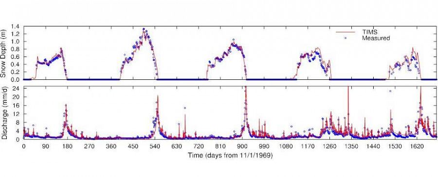
Snow depth and river discharge modeled by TIMS compared to measurements over a sub-catchment (8.4 km2) of the Sleepers River, Vermont.
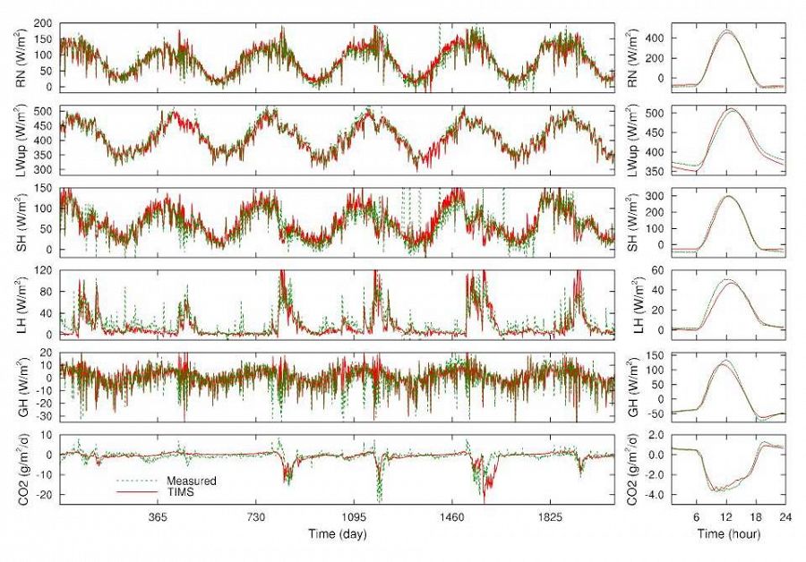
Daily-mean (left panels) and averaged diurnal variations (right panels) of net radiation (RN), outgoing longwave radiation (LWup), sensible (SH), latent (LH), ground (GH), CO2 fluxes modeled by TIMS compared to measured from May 6, 2004 – Dec. 31, 2009 at the Kendall sub-watershed (7.92 ha) of Walnut Gulch, Arizona.
Publications
2014
An integrated modelling framework of catchment-scale ecohydrological processes: 1 Model description and tests over an energy-limited watershed. Niu G.-Y., Paniconi C., Troch P.A., Scott R.L., Durcik M., Zeng X., Huxman T. and Goodrich D.C. (2014): Ecohydrology 7(2): 427–439
2014
An integrated modelling framework of catchment-scale ecohydrological processes: 2 The role of water subsidy by overland flow on vegetation dynamics in a semi-arid catchment. Niu G.-Y., Troch P.A., Paniconi C., Scott R.L., Durcik M., Zeng X., Huxman T. Goodrich D.C., and Pelletier J. (2014): Ecohydrology 7(2): 815–827

Explore Further
