Olyphant et al., 2016
Topographic correlations with soil and regolith thickness from shallow-seismic refraction constraints across upland hillslopes in the Valles Caldera, New Mexico
Olyphant J., Pelletier J.D., and Johnson R. (2016)
Earth Surface Processes and Landforms 41(12): 1684–1696
-

Catalina-Jemez, INVESTIGATOR
Abstract
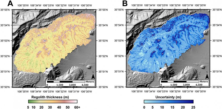
Map of predicted regolith thickness (A) generated using regression coefficients computed from the aggregation of all our data and map showing uncertainty (in meters) of regolith thickness (B)
How rock is weathered physically and chemically into transportable material is a fundamental question in critical-zone science. In addition, the distribution of weathered material (soil and intact regolith) across upland landscapes exerts a first-order control on the hydrology of watersheds. In this paper we present the results of six shallow seismic-refraction surveys in the Redondo Mountain region of the Valles Caldera, New Mexico. The P-wave velocities corresponding to soil (≤ 0.6 km s−1) were inferred from a seventh seismic survey where soil-thickness data were determined by pit excavation. Using multivariable regression, we quantified the relationships among slope gradient, aspect, and topographic wetness index (TWI) on soil and regolith (soil plus intact regolith) thicknesses. Our results show that both soil and regolith thicknesses vary inversely with TWI in all six survey areas while varying directly with slope aspect (i.e. thicker beneath north-facing slopes) and inversely with slope gradient (i.e. thinner beneath steep slopes) in the majority of the survey areas. An empirical model based on power-law relationships between regolith thickness and its correlative variables can fit our inferred thicknesses with R2-values up to 0.880 for soil and 0.831 for regolith in areas with significant topographic variations. These results further demonstrate the efficacy of shallow seismic refraction for mapping and determining how soil and regolith variations correlate with topography across upland landscapes.
Citation
Olyphant J., Pelletier J.D., and Johnson R. (2016): Topographic correlations with soil and regolith thickness from shallow-seismic refraction constraints across upland hillslopes in the Valles Caldera, New Mexico. Earth Surface Processes and Landforms 41(12): 1684–1696. DOI: 10.1002/esp.3941
 This Paper/Book acknowledges NSF CZO grant support.
Explore Further
