Pelletier et al., 2016
The influence of Holocene vegetation changes on topography and erosion rates: a case study at Walnut Gulch Experimental Watershed, Arizona
Pelletier J. D., Nichols M. H., and Nearing M. A. (2016)
Earth Surface Dynamics 4: 471-488
-

Catalina-Jemez, INVESTIGATOR
Abstract
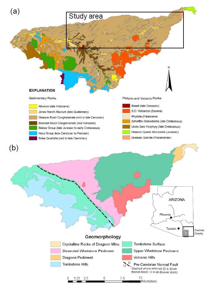
Maps of the bedrock geology and geomorphology of Walnut Gulch Experimental Watershed (WGEW). (a) Bedrock geology from Osterkamp (2008): rectangle identifies the portion of WGEW that is the focus of this study. (b) Geomorphic map from Osterkamp (2008): the boundary between the Dissected Whetstone Pediment and Upper Whetstone Pediment marks a key transition in landscape morphology, soil type, and vegetation cover.
Quantifying how landscapes have responded and will respond to vegetation changes is an essential goal of geomorphology. The Walnut Gulch Experimental Watershed (WGEW) offers a unique opportunity to quantify the impact of vegetation changes on landscape evolution over geologic timescales. The WGEW is dominated by grasslands at high elevations and shrublands at low elevations. Paleovegetation data suggest that portions of WGEW higher than approximately 1430 m a.s.l. have been grasslands and/or woodlands throughout the late Quaternary, while elevations lower than 1430 m a.s.l. changed from a grassland/woodland to a shrubland ca. 2–4 ka. Elevations below 1430 m a.s.l. have decadal timescale erosion rates approximately 10 times higher, drainage densities approximately 3 times higher, and hillslope-scale relief approximately 3 times lower than elevations above 1430 m. We leverage the abundant geomorphic data collected at WGEW over the past several decades to calibrate a mathematical model that predicts the equilibrium drainage density in shrublands and grasslands/woodlands at WGEW. We use this model to test the hypothesis that the difference in drainage density between the shrublands and grassland/woodlands at WGEW is partly the result of a late Holocene vegetation change in the lower elevations of WGEW, using the upper elevations as a control. Model predictions for the increase in drainage density associated with the shift from grasslands/woodlands to shrublands are consistent with measured values. Using modern erosion rates and the magnitude of relief reduction associated with the transition from grasslands/woodlands to shrublands, we estimate the timing of the grassland-to-shrubland transition in the lower elevations of WGEW to be approximately 3 ka, i.e., broadly consistent with paleovegetation studies. Our results provide support for the hypothesis that common vegetation changes in semi-arid environments (e.g., from grassland to shrubland) can change erosion rates by more than an order of magnitude, with important consequences for landscape morphology.
Citation
Pelletier J. D., Nichols M. H., and Nearing M. A. (2016): The influence of Holocene vegetation changes on topography and erosion rates: a case study at Walnut Gulch Experimental Watershed, Arizona. Earth Surface Dynamics 4: 471-488. DOI: 10.5194/esurf-4-471-2016
 This Paper/Book acknowledges NSF CZO grant support.
Explore Further
