Multiple Disciplines
More Info
We seek to understand how erosion and weathering control the architecture and function of the Critical Zone, the weathered, hydrologically active near surface environment. The headwaters of Boulder Creek encompass widely varying erosion histories —glacial scouring, slow post-Laramide denudation, and recent base level lowering —so that the effects of these on weathering can be explored.
The field sites span climate and ecological gradients from lower montane to alpine tundra. The Boulder CZO team has established research watersheds in each erosional regime (see Sites tab). Characterization of depth to bedrock, character of weathered materials, microbial ecology, stream water inorganic and organic chemistry, and meteorological parameters is underway. Field sites are on City of Boulder land, Boulder County Open Space, and U.S. Forest Service land, and share some overlap with the Niwot Ridge Long-Term Ecological Research (LTER) site, and the Southern Rockies-Colorado Plateau domain of the National Ecological Observation Network (NEON).
An Introduction To Our Research Topics
Geomorphology: Eric Winchell
Beavers. Ants. Gophers. Take any hike around where one of these animals lives and even the most casual of observers would proclaim that they are helping to shape the earth’s surface. While any geomorphologist would agree that biology plays a vital role within geomorphology, and vice versa, there remains too little communication between the disciplines about how the earth’s surface has been sculpted. An ecologist may focus on population dynamics while a geomorphologist may concentrate on the energy that molds and drives the landscape. In order to close the quantitative gap that persists between biology and geomorphology, I investigate the linkages between the geomorphic and ecological effects of northern pocket gophers (Thomomys talpoides) on the subalpine landscape of the Colorado Front Range.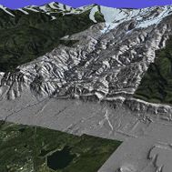
Geomorphology: Melissa Foster
Long-term rates of landscape evolution are difficult to constrain, yet are all-important in establishing rates of critical zone processes and the timing of geomorphic events in the landscape. I am using the cosmogenic radionuclides 10Be and 26Al to document long-term rates of bedrock lowering in the crystalline core of the Front Range, and to establish the timing of terrace generation and occupation along the western edge of the adjacent High Plains.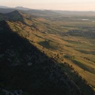
Geomorphology: Rachel Glade
Many landscapes sport hillslopes that are dotted with blocks of rock. Rather than being smooth and convex up, they have sharp edges that form scarps that serve as the source of the blocks. We are addressing the evolution of such landscapes, including hogbacks and flatirons in sedimentary rock (photo 1), dikes in volcanic terrain, and lumpy outcrop-riddled hills in crystalline terrain (photo 2). Using a combination of field work, experiments and numerical modeling, I am interested in untangling feedbacks between the transport and weathering of blocks of hard rock and mobile regolith, and how these interactions govern the evolution of the topography to produce specific, often iconic, landscape features.
Geophysics, Hydrology: Aspect controls on seismic anisotropy and groundwater flow paths: Aaron Bandler
My research explores the ability of hillslopes in Gordon Gulch to transmit water. Water typically moves through porous matrices and/or fractures in rock, and hypotheses suggest that the north- and south-facing slopes of Gordon Gulch have different subsurface architecture and different hydraulic conductivities. We use boreholes to examine fracturing in bedrock and saprolite, and seismic refraction to assess whether there is directional dependence of fractures. Using these data, we can compare the characteristics of fracturing (i.e. strike, dip, frequency, aperture), the degree of weathering, and the depth to geologic contacts.
Hydrology: Sachin Pandey Research Group
Spatial and temporal heterogeneity in subsurface water storage has been identified as a major knowledge-gap in Critical Zone science, despite its heavy influence on hydrochemistry and soil formation. For instance, we still lack a quantitative basis for characterizing the effect of dynamic fluid residence times, which are dictated by heterogeneity, on biogeochemical reactions, which drive weathering and solute fluxes in ground/surface waters. My research focuses on quantifying the extent of such heterogeneous fluid-rock interactions through the use of computational hydro-geochemical models.
Microbiology and Microbial Ecology of subsurface microbes: Paul Carini
Weathering processes aboveground and in surface soils have been relatively well studied, but we know far less about the factors that constrain weathering in deeper soils adjacent to parent materials. I employ a two-pronged approach to understand which microbial species are involved in weathering and to understand how their populations change through time. First, deep-dwelling soil microbes are isolated and assayed for their ability to weather minerals in the laboratory. Once weathering microbes are identified, molecular techniques are used to monitor the temporal population dynamics of these (and other) microbial species in the soils they were isolated from.
Microbiology and Microbial Ecology of Subsurface Microbes: Tess Brewer
Soil is essential for much of life on Earth. Microbes are ubiquitous in this environment – an estimated 108-109 microbial cells can be found in one gram of soil with a diversity ranging from a few hundred to thousands of species. Soil microbes participate in carbon sequestration, nutrient cycling, and soil formation - all critical ecosystem processes, yet are poorly understood.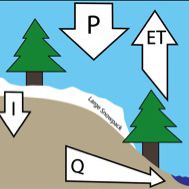
Snow Hydrology Group. Theo Barnhart
The mountain snowpack across the western US is declining in response to anthropogenic climate warming. I seek to understand how changes in snowpack amount, snowmelt rate, and snowmelt timing translate into changes in streamflow production. I also seek the physical mechanism responsible for controlling the snowmelt-streamflow production relationship, using both hydrologic models and collocated measurements of streamflow, snow water equivalent, evapotranspiration, and soil moisture. I employ models at the watershed, point scale and continental scale to test whether the mechanisms we observe in the field apply at larger scales.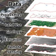
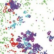
GIS & Remote Sensing
At the Boulder Creek CZO, all samples collected have a latitude and longitude. Based on these samples, we can create various layers such as stream discharge, snow survey points and soil samples. Maps, DEMs, attribute data, surface layers and images can be displayed simultaneously and dynamically linked. This can help scientists answer various questions regarding the Boulder Creek CZO, such as:(1)What controls the spatial variation in a critical zone
(2)How does critical zone development vary across erosional and ecological regmines
(3)How does the distribution of critical zone development control the hydrologic response of the catchment to snow and rainfall.
eric
melissa
rachel
Aaron
GIS icon
sanchin
paul
tess
theo
boulder Research Groups
View people and their activity per working group (foci and/or discipline based).
Discipline Tags
View people, news, events, publications, etc aggregated by discipline tag within and across CZOs. Most content is interdisciplinary and tagged with 2-3 disciplines.
Biogeochemistry
e.g. carbon, nitrogen
Biology / Ecology
e.g. vegetation, ecosystems
Biology / Molecular
e.g. microbes, DNA
Climatology / Meteorology
e.g. weather, air pressure
Data Management / CyberInfrastructure
e.g. databases, Q/A, portals
Engineering / Method Development
e.g. wireless networks
Geochemistry / Mineralogy
e.g. elements, isotopes
Geology / Chronology
e.g. bedrock, age dating
Geomorphology
e.g. landscape, sediment transport
Geophysics
e.g. seismic, radar, resistivity
GIS / Remote Sensing
e.g. maps, elevation, LiDAR
Hydrology
e.g. discharge, groundwater
Modeling / Computational Science
e.g. models, algorithms
Outreach / Education Research
e.g. assessment, interviews
Social Science
e.g. land-use history
Soil Science / Pedology
e.g. genesis, classification
Water Chemistry
e.g. surface water, solutes
Explore Further
