Annual Findings
(BcCZO-II) 2015 (year 2)
Boulder Creek Critical Zone Observatory
Interface and Zone 1: Land Surface and Mobile Regolith R.S. Anderson, D. Doak, H. Barnard, N. Molotch, S. Murphy, A. Blum, G. Tucker, S.P. Anderson, D. McKnight, N. Fierer
Lumps and blocks: Patchiness in the landscape. R.S Anderson paper on lumpy nature of glaciated valley floors was published (Anderson, RS, Geology, 2015) on the lumpy, which reflects a combination of underlying fracture spacing and competing mechanisms of glacial erosion. With newly arrived (2014 fall) PhD student Rachel Glade, he is developing numerical models and field data sets that target the lumpy bedrock-dotted landscapes of the BcCZO. They will first approach the layered rocks at the edge of the high Plains, including both hogbacks and the flatirons that are the icons of the Boulder landscape, as a training ground to address how to include discrete blocks into our thinking and our numerical algorithms. This spawned a separate NSF/GLD proposal that has been identified as a project to be funded.

PhD student Eric Winchell in meadow site in late Fall 2014. Flags denote gopher mounds,
colors each identify new mounds in any particular visit to the site.
Transport of mobile regolith: The roles of biology. Both trees and gophers have been studied in the context of mobile regolith transport. PhD student Eric Winchell (who passed his PhD comprehensive exam 2015) is working with Bob Anderson and Dan Doak to document the spatial and temporal patterns of gopher activity in the meadows that dot the montane landscape characteristic of the BcCZO. Winchell has demonstrated that the intensity of the digging can explain the presence of “stonelines” reflecting century scale overturn of the top 20 cm of soil. That the spatial pattern of digging evolves over the summer from the edges of the meadows toward their centers inspired the hypothesis that the subsurface thermal and soil-moisture fields tightly control the location of gopher activity. The team is also developing data sets of tree age that can be combined with gopher herbivory to test a hypothesis that gophers play a key role in sharpening and maintaining the edges of meadows. Winchell mentored an REU student in summer 2014 (Jorgie Marquez), and will mentor another student in summer 2015 (Andrea Weber). In an associated effort, undergraduate researcher Emily Gulick is working with Dan Doak on a spatial analysis of boundaries between meadows and forests in the same setting as Winchell’s study.
Surface Hydrology: Infiltration, runoff, and water balance. We now have five complete water years of monitoring of snow, soil moisture, water table dynamics, and runoff in Gordon Gulch watershed through above-average, below average, and “normal” precipitation years. S.P. Anderson is analyzing these rich datasets to develop conceptual models of precipitation-runoff 4 in this watershed. She has a manuscript in preparation for submission in summer 2015 (Anderson, SP et al, Water Resources Research, in prep).
Colorado school of Mines graduate student Sydney Wilson is working with Kamini Singha and Mike Gooseff (faculty arriving at CU in July 2015), on hyporheic exchange and groundwater infiltration in Gordon Gulch. Hyporheic exchange and groundwater infiltration into the stream was estimated during the three tracer tests performed from August to November 2014. Preliminary results suggest little difference in transient zone storage during these months. Breakthrough curves from tests and geophysical images across the stream during the tracer test are below.
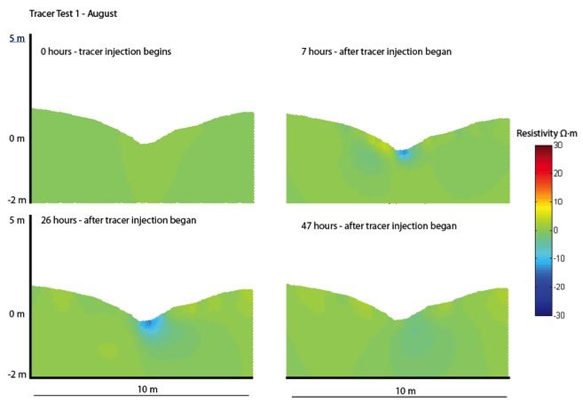
geophysical images across the stream during the
tracer test
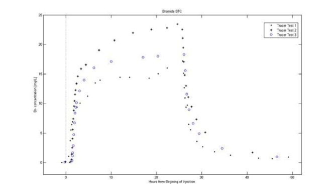
Breakthrough curves from tests
Snow in the BcCZO. Noah Molotch and graduate student Theo Barnhart are exploring the response of evapotranspiration and streamflow to shifts in snowmelt timing and rate. They have compiled observations of evapotranspiration from eddy covariance and snowpack measured at a co-located snow pillow and ultrasonic snow depth sensors from a forested site on Niwot Ridge, CO. These analyses explore the sensitivity of hydrologic partitioning of snowmelt between runoff and evapotranspiration using interannual variability. Analysis of adjacent soil moisture data allows hypothetical mechanisms of snowmelt driven runoff generation to be tested. A comparative data set at Providence Creek in the Southern Sierra CZO is available, enabling a cross-CZO comparison. Complementary to the observational data analysis, the Regional Hydro-Ecologic Simulation System (RHESSys) is being used to test a wide range of snowmelt scenarios. Calibrated simulations of Como Creek on Niwot Ridge are underway, which prepare them for model testing.
Preliminary results show that growing season partitioning of snowmelt between evapotranspiration and runoff is strongly controlled by the ablation slope (i.e. the intensity of snowmelt). This suggests that rapid snowmelt is better able to overwhelm atmospheric demand and bring the soil to field capacity, causing recharge and generating streamflow.
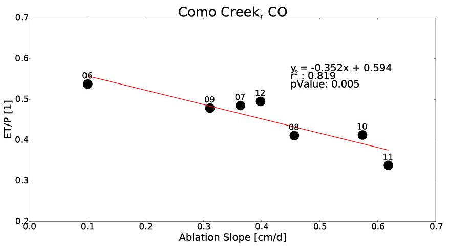
The intensity of snowmelt (ablation slope) controls how snowmelt is partitioned between evapotranspiration (ET) and runoff. Data are normalized by annual precipitation (P).
Using a space for time substitution and the Variable Infiltration Capacity (VIC) Model they see the same pattern across the mountainous, runoff producing regions of the western United States. Relative to the Budyko Framework, model grid cells with more rapid snowmelt overproduce runoff relative to the Budyko curve.
BcCZO Post-doctoral Fellow Dave Barnard is working with Toby Minear (USGS) to image (LiDAR) and characterize forest canopy temperature and radiation transfer to better inform snow pack energy balance computations under canopy cover.
Forest Evapotranspiration (ET). Holly Barnard student Hallie Adams published her MA thesis work (Adams et al., Ecosphere, 2014) on tree growth rates. BcCZO Post-doctoral Fellow Dave Barnard is working on questions concerning the influence of site elevation, aspect, and snow cover persistence on tree sapflow (i.e. transpiration) at three sites in the Boulder Creek CZO and an additional sub-alpine site near the Niwot Ridge LTER. These questions will lead to better knowledge of the role of vegetation transpiration on the hydrologic cycle and water cycle investigations. He is compiling sapflow, snow depth and meteorological data from Betasso, Gordon Gulch and Niwot Ridge, and will continue to monitor and upkeep sapflow collection sites throughout the remainder of 2015. Data analysis is underway and a manuscript 6 is expected by early September.
Colorado School of Mines (Mines) grad student Rachel Feist, working with Kamini Singhaand Holly Barnard, is investigating the role of tree transpiration in soil and rock moisture movement- see Figure below.
The role of disturbance. Sheila Murphy continues monitoring runoff and water quality in the burned areas within the Boulder Creek Watershed to evaluate recovery from wildfire and flooding. She has instrumented three sites with continuous monitoring of turbidity, specific conductance, and discharge, and will again collect storm samples to correlate with the continuous monitoring. This work will enable us to assess the climate and hydrological conditions under which solutes and sediment are transferred to the stream.
Substantial hydrologic and geochemical responses downstream of a burned area were primarily driven by convective storms with a 30-minute rainfall intensity >10 mm h-1. These storms, which typically occur several times each year in July-September, are often small in area, short-lived, and highly variable in intensity and geographic distribution. We measured total suspended sediment, dissolved organic carbon, nitrate, and manganese concentrations that were 10 to 156 times higher downstream of a burned area compared to upstream during relatively common rainstorms, and water quality was sufficiently impaired to pose water treatment concerns. Short-term water-quality impairment was driven primarily by increased surface runoff during higher intensity convective storms that caused erosion in the burned area (including from historical mining waste), and transport to streams. Annual sediment yields downstream of the burned area were controlled by storm events and subsequent remobilization, whereas dissolved organic carbon yields were closely linked to annual runoff and thus were more dependent on interannual variation in spring runoff. Nitrate yields were highest in the third year post-wildfire. We have demonstrated that water quality can be altered for several years after wildfire.
Unanticipated opportunities from the September 2013 storm. We pushed hard to use LiDAR data to analyze landsliding in the storm. Researcher Scott Anderson, hired under the auspices of a RAPID grant, used FEMA LiDAR data collected in November 2013 and the BcCZO LiDAR data from August 2010 to compute a DEM of difference. The results, published in Anderson et al. (2015, Geology), showed 15 mm of lowering on average in basins with failures in crystalline rock. This is equivalent to ~400 years of denudation based on basinaveraged 10Be rates. Scott Anderson took a job with the USGS (Tacoma) working on 7 landslides in September 2014, and so has not continued working on the BcCZO datasets. REU student Dave Schellhase analyzed the velocity of debris flows from field evidence in several debris flow chutes. His data have been incorporated into a laboratory exercise used by SP Anderson in her Geomorphology class.
Water samples collected at locations we could access during and immediately following the storm (many roads were closed), are still being processed. Graduate student Garrett Rue will complete dissolved organic matter analysis of filters and frozen samples in summer 2015. The groundwater well at Betasso created from our “drill-the-ridge” coring project in January 2013 yielded important data on the groundwater response to this event, which we continue to follow. CU undergraduate student Satya Akquia is completed a senior thesis on breakdown of shale clasts such as were found on floodplains of rivers on the Plains following the storm.
Interface 2: Base of mobile regolith and weathered rock/saprolite R.S. Anderson, G. Tucker, S.P. Anderson
Lowering rates. Graduate student Melissa Foster, working with R.S. Anderson and S.P. Anderson has completed analysis of 10Be samples to determine denudation rates at our Betasso field site. This cosmogenic radionuclide (CRN) data will complement U-series analyses that collaborator François Chabaux (Univ. Strasbourg, France) has done. A manuscript is now in preparation on the combined 10Be and U-series analyses. This work was presented at the EGU General Assembly in 2015 (Anderson SP et al., Pelt et al). Meanwhile, Foster et al. (2015, GSA Bulletin) on denudation in Gordon Gulch was published.
Melissa Foster and Bob Anderson have completed the analysis of the incision history of Lefthand Creek and associated strath terraces (Foster et al., in prep for EPSL). This importantly constrains longterm erosional history on the edge of the High Plains, which in turn governs the boundary condition for the master streams draining the crystalline core of the Front Range. These record a punctuated erosional history in which bedrock-cut (strath) terraces broaden through time by lateral erosion of shale rock valley walls, and are occupied by the streams and associated alluvial deposits for tens to hundreds of thousands of years before being abandoned by vertical incision into the shale. This work reconciles age estimates based upon the degree of development of soils on these surfaces, with the cosmogenic radionuclide-based ages (including 10Be, 26Al).
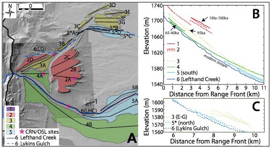
Terrace sites on Lefthand Creek, north of Boulder at the edge of the High Plains. Colors denote terraces of different elevations, the upper three having been dated using CRNs and OSL. Ages and durations of occupation are noted on 8 the long profiles of the terraces in the upper right plot. (from Foster et al., in prep.)
Rock fracture and Entrainment. We do not have any graduate students working on these topics at present. Kamini Singha has begun a collaboration with external investigators Taylor Perron (MIT) through an Army grant, and with Steve Martel (U Hawaii) and Steve Holbrook (U Wyoming) in which the role of sheet fracturing and topographic stress was explored in Gordon Gulch in summer 2014. A manuscript is in preparation.
Hydrology and chemical weathering of saprolite. Graduate student Joe Mills, working with S.P. Anderson, is writing a manuscript on several years of water chemistry from Gordon Gulch watershed (stream, groundwater, springs, precipitation, snow, and a small number of lysimeter samples) to examine the interplay of weathering and water flow paths in the watershed. Graduate student Sachin Pandey, working with Hari Rajaram, set up the reactive transport model PFLOTRAN for chemical weathering in fractured rock. Modeling results demonstrate the time-dependence of weathering rates induced by transport limitations in fractured rock. As primary minerals become depleted near the fracture-matrix interface, diffusion limitations result in slower bulk weathering rates. A manuscript is in preparation.
Interface 3: Deep Weathering Front A. Templeton, N. Fierer, K. Singha, D. McKnight, H. Rajaram, A. Sheehan, S.P. Anderson
A key set of questions about the deep critical zone revolves around the roles of microbes in the chemical evolution of rock far below the surface. Noah Fierer and grad student Tess Brewer are working on microbes in soils. Tess is trying to understand the dominant Verrucomicrobia found in the Gordon Gulch subsurface horizons. She now has the genome from this bacterium and is using the genome to investigate its physiological capabilities. She is also trying to grow this bacterium in the lab with the ultimate goal of figuring out why it is so abundant in the BcCZO soils and its roles in soil biogeochemistry.
In another project, Tess Brewer is investigating the diversity and function of microbial communities associated with rock surfaces across the globe. To do this, she collected samples from the surfaces of >250 tombstones across North America, South America, and Europe. She has found strong effects of sampling location, rock type, and tombstone age on the types of microbes found on the tombstone surfaces. She is currently investigating in more detail how rock type influences the functional capabilities of these communities with the goal of understanding microbial metabolic strategies associated with mineral weathering.
CS Mines graduate student Richard Magill is working with Kamini Singha, Taylor Perron and Steve Martel on fracture characterization in Gordon Gulch. Seven boreholes (6-12 m deep) have been logged with optical televiewer and gamma.
Steve Holbrook (WyCEHG) found much less spatial variation in depth to fresh rock in Gordon Gulch relative to the relief than they saw in the Calhoun CZO and elsewhere. This supports an analysis of weathering slaved to topographic stress derived by Steve Martel, Taylor Perron, and Seulgi Moon. A manuscript is in preparation.
Science Implementation: Integrative activities
We set out modeling objectives in our proposal that will integrate across the interfaces discussed above, and across disciplinary boundaries (e.g., geomorphology, hydrology, geobiology, ecohydrology). We laid out plans for integrative modeling in three areas: water, landscape evolution, and future-casting. At this point, our integrative modeling efforts have been directed primarily at landscape evolution. Two manuscripts are in advanced stages that integrate in differing ways. Abigail Langston developed a model of the genesis of terrace 9 flights along the foothills of the Front Range. A landscape evolution model was used to map out the consequences of three alternative mechanistic hypotheses for the origins of flights of gravel-capped strath terraces along the fringes of the Colorado Front Range. Her manuscript (Langston, A.L., G.E. Tucker, R.S. Anderson, Interpreting climate-modulated processes of terrace development along Colorado Front Range using a landscape evolution model) was submitted to JGR-Earth Surface in February 2015, and a revision was submitted in May 2015. Melissa Foster has been building histories of exhumation through several chronometers applied to features on the Plains. She has one manuscript that will be submitted by June 1, 2015 (Foster, M., Duhnforth, M., Gray, H., Anderson, R.S., Incision of Lefthand Creek, Colorado as constrained by 10Be , 26Al and OSL profiles, for ESPL), and is working on a second manuscript that will integrate our understanding of exhumation from the Plains to the Continental Divide for Geology by July 2015.
PhD student Eric Winchell in meadow site in late Fall 2014. Flags denote gopher mounds,
colors each identify new mounds in any particular visit to the site.
geophysical images across the stream during the
tracer test
Breakthrough curves from tests
The intensity of snowmelt (ablation slope) controls how snowmelt is partitioned between evapotranspiration (ET) and runoff. Data are normalized by annual precipitation (P).
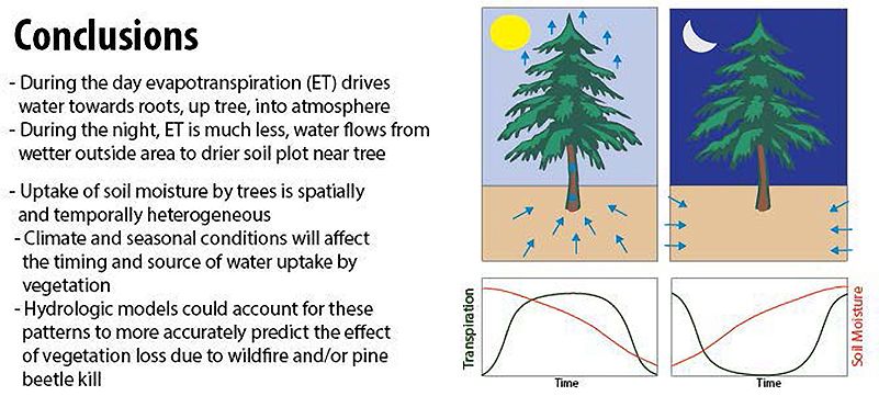
Conclusions
Terrace sites on Lefthand Creek, north of Boulder at the edge of the High Plains. Colors denote terraces of different elevations, the upper three having been dated using CRNs and OSL. Ages and durations of occupation are noted on 8 the long profiles of the terraces in the upper right plot. (from Foster et al., in prep.)
Explore Further
