Geomorphology: Melissa Foster Research Group
Long-term rates of landscape evolution are difficult to constrain, yet are all-important in establishing rates of critical zone processes and the timing of geomorphic events in the landscape. I am using the cosmogenic radionuclides 10Be and 26Al to document long-term rates of bedrock lowering in the crystalline core of the Front Range, and to establish the timing of terrace generation and occupation along the western edge of the adjacent High Plains.
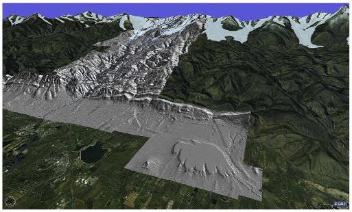
Image: LiDAR image of the Colorado Front Range and western High Plains. The rates of lowering of the various elements of this landscape, from the strath terraces in the foreground to the crystalline hillslopes in the interior of the range, can be obtained using the million-year half-life cosmogenic radionuclides 10Be and 26Al.
This group is tagged with:
-
Lowering rates in the crystalline core of the Front Range
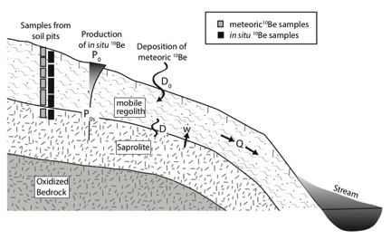
As the timescale of surface processes is often 103-105 years, cosmogenic radionuclides (CRNs) are a powerful tool in constraining the timing of landscape evolution. In situ and meteoric 10Be are the most-widely used CRNs in geomorphic studies of regolith. In situ 10Be is produced within the silicon and oxygen located inside the crystal lattice of quartz; meteoric 10Be is produced in the atmosphere and then deposited onto the outside of particle surfaces via via rainfall or dust accumulation. Because the accumulation mechanisms for in situ and meteoric 10Be are fundamentally different, using the two approaches together provides independent constraints on lowering rates and residence times.
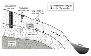
Schematic of hillslope segment. Mobile regolith, saprolite, and oxidized bedrock are shown, along with processes of meteoric 10Be deposition and in situ 10Be production.
We use both in situ and meteoric 10Be to calculate residence times and production rates for mobile regolith on hillslopes in a non-glaciated catchment within the Colorado Front Range. We also develop analytical models of 10Be concentrations to test the steady-state assumption underlying our calculations. Close agreement between meteoric and in situ results indicates that upper and middle hillslope positions are eroding both steadily and uniformly; mobile regolith residence times are 10-20 ka and production rates are 3.1 cm/ka. Comparison with our steady state analytical model indicates that these numbers are likely no closer than ± 25% of the geomorphic reality. Our data also reveal that large quantities of meteoric and in situ 10Be are stored not only in mobile regolith but in the underlying saprolite, highlighting the importance of careful field identification of the mobile regolith-saprolite boundary.
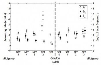
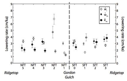
Saprolite ( ) and surface lowering ( ) rates, Gordon Gulch catchment, Boulder Creek CZO. Lowering rates are derived from both in situ and meteoric 10Be inventories on both north-facing (NF) and south-facing (SF) slopes of the Gordon Gulch catchment.
Generation and occupation of strath terraces along the western High Plains
New Quaternary dating methods, such as cosmogenic radionuclide dating, allow us to constrain existing relative stratigraphy with absolute ages. However, such absolute ages can differ between methods and sometimes disagree with established relative chronologies. In this study, we investigate gravel-capped strath terraces along the western High Plains of Colorado in an attempt to reconcile disparate age estimates. We use 10Be and 26Al cosmogenic radionuclides (CRNs), optically stimulated luminescence (OSL), and thermal-transfer OSL (TT-OSL), to date three strath terraces, all cut and deposited by Lefthand Creek, draining the crystalline core of the Front Range. Our study reveals: (1) a long history of fluvial occupation (0.5-1.5 Myr duration), with recent (<120 ka) fluvial abandonment of the high Table Mountain terrace; (2) a brief occupation of a narrow spillway at 96 ± 4 ka; and (3) a long period of fluvial occupation of a lower terrace, marked by the deposition of a lower soil between 50 and 75 ka, followed by deposition of an upper soil at 40 ± 5 ka. Our interpretation of burial and erosion at Table Mountain reconciles both the young CRN abandonment ages previously reported (Dühnforth et al., 2012) and the old soil-profile ages reported by soil geomorphologists (e.g., Madole, 1963). In conjunction with other recent CRN studies of strath terraces along the Colorado Front Range, our data reveal long periods of aggradation and lateral planation, sometimes lasting several glacial-interglacial cycles, punctuated by brief episodes of rapid incision. These data call into question what a singular terrace “age” represents, as the strath may be cut at one time (“cutting-age”) and the terrace may be abandoned at a much later time (“abandonment age”). These interpretations would not have been possible without the combination of multiple dating techniques. Our study therefore both provides a more nuanced and complex history of fluvial incision of the western edge of the High Plains, and serves as a cautionary tale for the extraction of climate and tectonic information from strath terraces based on a single dating method.
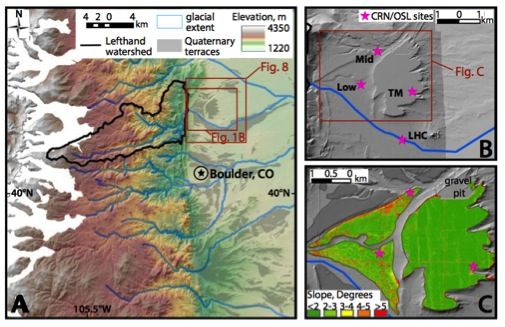
Quaternary terraces and study area. (A). Shaded relief map of the Colorado Front Range, delineating glacial extent (Madole et al., 1998) and Quaternary terraces (gray) along the western High Plains (digitized from Trimble and Machette (1979) and Cole and Braddock (2009). (B). Hillshade imagery from 1-m LiDAR DEMs (darker gray) and 10-m DEMs. Sample sites include (TM) Table Mountain, (Mid) Middle terrace, (Low) Low terrace, and (LHC) modern Lefthand Creek. (C). Slope-shade map of study terraces. Slopes are very low, and relief is very small.
Schematic of hillslope segment. Mobile regolith, saprolite, and oxidized bedrock are shown, along with processes of meteoric 10Be deposition and in situ 10Be production.
Saprolite ( ) and surface lowering ( ) rates, Gordon Gulch catchment, Boulder Creek CZO. Lowering rates are derived from both in situ and meteoric 10Be inventories on both north-facing (NF) and south-facing (SF) slopes of the Gordon Gulch catchment.
Quaternary terraces and study area. (A). Shaded relief map of the Colorado Front Range, delineating glacial extent (Madole et al., 1998) and Quaternary terraces (gray) along the western High Plains (digitized from Trimble and Machette (1979) and Cole and Braddock (2009). (B). Hillshade imagery from 1-m LiDAR DEMs (darker gray) and 10-m DEMs. Sample sites include (TM) Table Mountain, (Mid) Middle terrace, (Low) Low terrace, and (LHC) modern Lefthand Creek. (C). Slope-shade map of study terraces. Slopes are very low, and relief is very small.
-
Contacts
Alumni-Former
 .(JavaScript must be enabled to view this email address)
Geomorphology, soils
-
Featured Publications
2012
Unsteady late Pleistocene incision of streams bounding the Colorado Front Range from measurements of meteoric and in situ 10Be. Dühnforth, M., R. S. Anderson, D. J. Ward and A. Blum (2012): JGR-Earth Surface 117, F01023
Explore Further
