Geomorphology: Rachel Glade Research Group
Many landscapes sport hillslopes that are dotted with blocks of rock. Rather than being smooth and convex up, they have sharp edges that form scarps that serve as the source of the blocks. We are addressing the evolution of such landscapes, including hogbacks and flatirons in sedimentary rock (photo 1), dikes in volcanic terrain, and lumpy outcrop-riddled hills in crystalline terrain (photo 2). Using a combination of field work, experiments and numerical modeling, I am interested in untangling feedbacks between the transport and weathering of blocks of hard rock and mobile regolith, and how these interactions govern the evolution of the topography to produce specific, often iconic, landscape features.
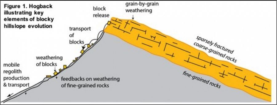
Image: Understanding blocky landscapes requires knowledge of the processes that release blocks from fracture or joint-segmented bedrock, transport of those blocks downslope, interruption of flow of the mobile regolith by the presence of blocks, and the reduction of block size by weathering.
This group is tagged with:
-
Hogback
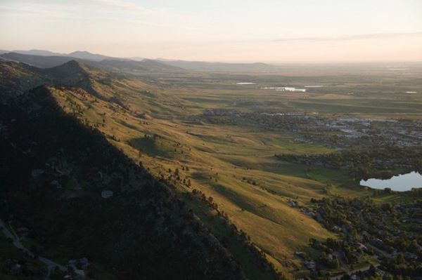
Photo 1. Hogbacks to the west of Boulder, looking north. Cretaceous sandstones dominate east-dipping structure. Shales stratigraphically above the sandstones form low-relief edge of the High Plains. Photo: R.S. Anderson
lumpy outcrop-riddled hills
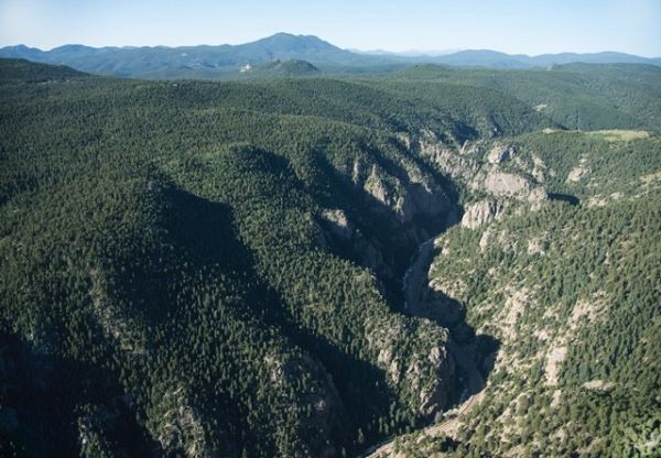
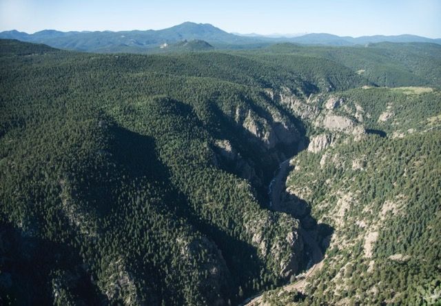
Photo 2. Deep gorge of Boulder Creek immediately west of Boulder, looking WSW. Boulder Canyon is etched into photo 2. the Boulder Creek granodiorite, with steep rocky walls bounding the bedrock stream. Hillslopes are dotted with outcrops. Outside the inner canyon the landscape displays lower relief, although the hills remain rocky. Photo: R.S. Anderson
This project, initiated as a CZO project and now funded with a separate NSF grant, will entail three distinct sets of tasks. 1) Targeted fieldwork will include measurements of fracture density, block distribution, soil thickness, and slope profiles in blocky hillslope environments. Measurements of soil thickness around rocky outcrops will constrain 2D models of soil flow. Fortunately, suitable hillslopes near Boulder represent a variety of geologic structures, from dipping sedimentary rocks to randomly fractured crystalline rocks. I have also identified and begun work at an ideal field site for the vertical end-member at Shiprock, NM. There, blocks of basalt derived from several many-km long vertical dikes armor straight-to-concave shale hillslopes (Figure 2). This summer I collected laser surveys of slope profiles, as well as measurements of block distribution using image analysis. Field measurements will ultimately constrain numerical models, as well as inform conceptual models of blocky hillslope processes.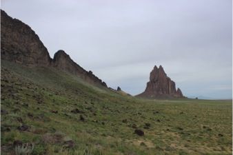
Figure 2: Dike at Shiprock, NM
2) Physical experiments will allow us to explore transport mechanics and the dependence of sediment flux on gradient on a heterogeneous hillslope. We will use a combination of a soil analog (Kinetic Sand) and micro-blocks of rock to build a “rocky” hillslope that will then be disturbed with a vibrating motor to mimic hillslope “creep” transport processes; resulting video and particle tracking using ImageJ software will illuminate the patterns of motion. Further experiments will explore the mechanisms of soil flow in response to rain events using a small sloping basin and misters. We will explore the processes of wetting and drying as well as viscous flow. 3) Numerical Modeling Using field and experimental data, we will develop 1D and 2D numerical models in MATLAB to explore the evolution of blocky hillslopes. We face two main challenges in developing this model. First, we must represent the initiation of motion of blocks of rock through processes such as toppling, sliding, and loosening due to tree roots. Once released, the subsequent downslope transport of blocks both large and small must be tracked. Geologic structure will be incorporated through choice of fracture spacing and orientation in the model domain. The challenge lies in marrying the efficiency of continuum models of soil motion with those that allow treatment of individual particles. I have made preliminary models of hillslope evolution at Shiprock, NM that can capture differential weathering of basalt and shale, the transport of soil by wetting and drying, and 2D soil flow around a block (Figure 3). This latter model suggests one way in which the presence of blocks can alter soil flux, and therefore the profile of rocky hillslopes.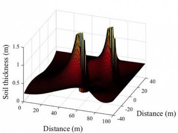
Figure 3: Soil buildup upslope of two blocks, and development of wakes downslope
Photo 1. Hogbacks to the west of Boulder, looking north. Cretaceous sandstones dominate east-dipping structure. Shales stratigraphically above the sandstones form low-relief edge of the High Plains. Photo: R.S. Anderson
Photo 2. Deep gorge of Boulder Creek immediately west of Boulder, looking WSW. Boulder Canyon is etched into photo 2. the Boulder Creek granodiorite, with steep rocky walls bounding the bedrock stream. Hillslopes are dotted with outcrops. Outside the inner canyon the landscape displays lower relief, although the hills remain rocky. Photo: R.S. Anderson
Figure 2: Dike at Shiprock, NM
Figure 3: Soil buildup upslope of two blocks, and development of wakes downslope
-
Contacts
-
Boulder, GRAD STUDENT
2 People
INVESTIGATOR
.(JavaScript must be enabled to view this email address)
INSTAAR
CU-Boulder
Geomorphology, mechanics and timing of landscape evolution.

GRAD STUDENT
.(JavaScript must be enabled to view this email address)
Geomorphology
-


Explore Further
