MODELS

Models of Critical Zone elements
In much of the research carried out in the Boulder Creek CZO, we employ numerical models of critical zone systems. The activity of modeling serves several purposes, among them i) testing an existing theory against data we have collected, and ii) formalizing our logic about a set of surface processes that are linked in complex ways that disallow use of simpler analytic solutions.
The models illustrated here exemplify both of these motivations for modeling. In the Dühnforth paper on the Green lake Valley deglaciation, for example, a numerical glacial model was employed to explore various potential deglaciation histories, each of which predicted a profile of 10Be concentration in the valley to test against 10Be data. In the Dühnforth paper on the ages of the terraces outboard of the mountain front, we used numerical models of the accumulation of 10Be in depth profiles to formally interpret the measured profiles for the age of the surface.
We have also employed numerical models to explore the behavior of hillslopes and glacial valley floors to proposed sets of model rules. These are often inspired by observations made in the BcCZO, and are faithful to the local meteorological setting, but are not designed to “fit” particular hillslope or valley floor profiles.
The models vary in style and method, ranging from 1D to 2D planview, and from finite difference to discrete particle approaches.
Modelling News
FEATURED
CZ colleagues: Please contact us about proposals for NSF’s CZ Collaborative Network, due 02 Dec 2019
08 Jul 2019 - CZO will end Nov 2020, succeeded by the “CZ Collaborative Network”. Let’s explore how the CZ community can build upon the CZOs via new NSF proposals.

FEATURED
Korean KNU CZO visit great success!
01 Feb 2016 - BcCZO had a great visit from the KNU CZO in South Korea. A new CZO that has been funded for about 5 months...

FEATURED
BcCZO at AGU (American Geophysical Union) 14-18 Dec, 2015. Abstracts on the website!
02 Dec 2015 - Criticalzone Science at AGU (American Geophysical Union) fall meeting 2015 December 14-18. 2015 Fall Meeting Program Download the CZO...
Noah Molotch on KGNU
08 Feb 2018 - The CZO's own Dr. Noah Molotch, director of CWEST, appeared on KGNU during a piece on snow depth and Snow Telemetry (SNOTEL). KGNU is an...
Water Resources Research Special Collection: Concentration-discharge relations in the critical zone
30 Oct 2017 - Water Resources Research published a new special collection in September 2017 featuring concentration-discharge research from multiple CZOs.
EOS: Taking the Pulse of the Earth’s Surface Systems
04 Dec 2015 - Taking the Pulse of the Earth's Surface Systems In September of 2014, Laurel Larsen (UC Berkley), Elizabeth Hajek (Penn State), and others...
Using a CZO network to explore the architecture, dynamics and evolution of the Critical Zone
03 Nov 2014 - The US CZO National Office has organized a webinar on December 8, 2014 at 11AM - 12:30 PM ET.
Reactive Transport Modeling Survey – Community Needs for Biogeochemical Studies
08 Apr 2014 - Reactive Transport Modeling Survey – Community Needs for Biogeochemical Studies The below survey is designed by Alexis Navarre-Sitchler, Kate...
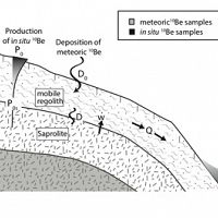
10Be on hillslopes
Models of 10Be on hillslopes require acknowledgement of transport within the mobile regolith
Cosmogenic radionuclide concentrations in hillslopes evolve by production, decay, and lateral transport of nuclides in regolith.
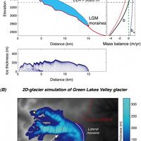
Alpine glaciers 1&2D
Numerical models of alpine glaciers in 1 and 2 dimensions
Computes glacial ice motion including internal deformation and sliding in flowline (1D) or in planview (2D) in an alpine valley
CHILD
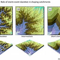
Channel-Hillslope Integrated Landscape Development (CHILD) model
Computes time evolution of a topographic surface z(x,y,t) by erosion (fluvial, hillslope) and sediment transport
Digital glacier bed
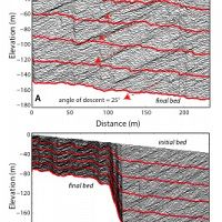
Digital model of glacier bed
Computes evolution of a glacial bed at the 1-meter scale , mimicking both abrasion and block removal by quarrying
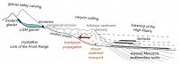
Front Range schema
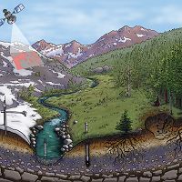
The geomorphic systems of the Front Range and the High Plains
The geomorphic systems of the Front Range and the High Plains are linked.
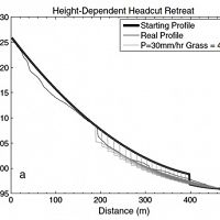
GullyErosionProfiler
1D model of gully longitudinal profile evolution
Calculates the long-profile evolution of a gully channel containing an abrupt step (headcut).
Hillslope trajectory
Hillslope trajectory model
Combination of analytical and numerical methods captures soil particle trajectories on a steady state hillslope
Landlab
Landlab: A Python-language library for 2D numerical modeling
Landlab enables researchers to efficiently create and/or combine 2D numerical models.
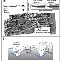
Landscape linkages
Hillslopes between rapidly downcutting streams steepen in the wake of propagating knickpoints
Hillslopes between rapidly downcutting streams steepen in the wake of propagating knickpoints.
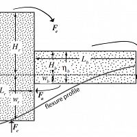
Range and Basin
Range and Basin: A Simple Model of Mountain Range and Basin Evolution on a Flexing Lithosphere
Computes the time evolution of mean elevation and “extra” crustal thickness for a hypothetical mountain range and adjacent forel
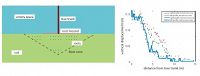
Root deformation
Particle model to simulate soil deformation associated with roots
Employs the discrete element model LIGGGHTS to compute displacement of particles in near-surface soil
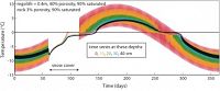
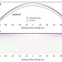
Thermal hillslope
Numerical hillslope model and its thermal state
Computes evolution of topography, soil thickness, and damage in the underlying rock driven by spatial variations in the surface
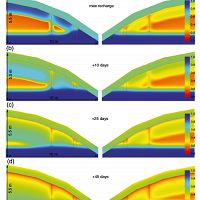
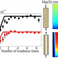
VS2Di
Using VS2Di to study aspect-related controls on vadose-zone moisture
2D model of subsurface moisture dynamics in the vadose zone. Model written by R. Healy, USGS.
Explore Further
