Landscape linkages
Hillslopes between rapidly downcutting streams steepen in the wake of propagating knickpoints
Hillslopes between rapidly downcutting streams steepen in the wake of propagating knickpoints.
Model Category: Conceptual
Image: Hillslope and groundwater response to fluvial downcutting along the margin of the Front Range
-

Boulder, INVESTIGATOR
-
Boulder, INVESTIGATOR
-
Boulder, INVESTIGATOR
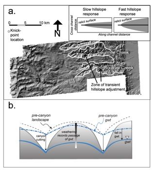
a) LiDAR hillshade of swath of Colorado Front Range, centered on Boulder Creek watershed, outlining (white line) the areas of hillslope adjustment to river incision. The present locations of knick zones in Boulder Creek, a tributary called Fourmile Creek, and a portion of Left Hand Creek (not labeled) are shown with large white dots. Inset shows the relationship between the area of transient hillslope response and knickpoint propagation (or celerity) rates (Mudd and Furbish, 2007). In this LiDAR hillshade, U-shaped glaciated headwater valleys are discernable on western headwaters of the river systems. The low relief Rocky Mountain Surface lies between these zones of erosional rejuvenation. b) Schematic cross section across an interfluve of two channels such as Boulder Creek and Fourmile Creek, illustrating the potential influence of an episode of rapid fluvial incision on the groundwater fields in interfluves. Initial topography and associated ground water table (gwt) position shown in dashed lines. Canyon cutting accelerates hillslope response nearest canyons, and a lagged response on the crest. The water table drops as the canyon is cut, increasing the depth of the hydrologic “active layer”. The influence of changes in groundwater system on weathering is not well known. (from Anderson et al., 2012, Figure 7)
Publications
Explore Further
