Range and Basin
Range and Basin: A Simple Model of Mountain Range and Basin Evolution on a Flexing Lithosphere
Computes the time evolution of mean elevation and “extra” crustal thickness for a hypothetical mountain range and adjacent forel
Model Category: Numerical
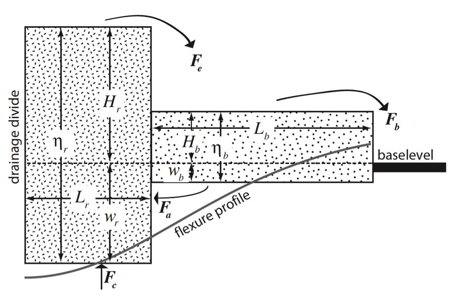
Image: Schematic illustration of range-basin model, which represents a cross-section of a half-range (left column) and adjacent sedimentary basin (right column) on a flexing elastic lithosphere (thick gray line). From: Tucker, G. E., & van der Beek, P. (2013). A model for post‐orogenic development of a mountain range and its foreland. Basin Research, 25(3), 241-259.
-

Boulder, INVESTIGATOR
Peter van der Beek - Université Joseph Fourier, Grenoble, France
The Boulder Creek CZO sits within the Colorado Front Range, which has an unusual and somewhat complicated geomorphic history. It was formed as a thrust-faulted range from the late Mesozoic to early Cenozoic era (roughly speaking about 70 to 40 million years ago). Like other parts of the Colorado Rockies, the eastern flank of the Front Range has undergone episodes in which sediment has accumulated at its feet (“buried in its own debris”), and times in which the eastern foothills have been exhumed again—a process that continues today. In order to understand the factors that may be driving the evolution of the Front Range topography, it is useful to consider what we would expect in the simplest case: that of a range that is in an overall state of decay. If we can understand the simple “default” case, then we can begin to identify anomalies and seek explanations. The figure above represents a simple mathematical model in which a mountain range and its adjacent basin are represented as “blocks” resting on a flexible lithosphere that bends like a steel beam when loaded or unloaded. Erosion of the range feeds sediment to the basin, which in turn feeds it further on to a baselevel (such as a major axial river, a coastline, or simply a location that is considered to have a fixed altitude). Calculations with this model revealed that the normal “expected” state for a decaying mountain range is for the adjacent sedimentary basin to erode along with it. In the case of the Rockies, this theoretical prediction is consistent with the observation that sedimentation in the eastern plains dwindled and turned to erosion as mountain-building waned in the early Cenozoic. However, the High Plains appear to have switched back into a mode of net sedimentation (albeit with frequent alternations between erosion and deposition) between about 19 and 5 million years ago. Model calculations suggest that climate change could potentially provide an explanation for this switch, if the change were of the right sort to either weather rock more easily in the range, or retard its transport out of the basin. However, the expected time scale for such a process would be relatively short—shorter, it seems, than the 14-million-year duration of stability to minor sedimentation in the Miocene High Plains. Meanwhile, researchers have pointed to the region’s high elevations as evidence for regional “epeirogenic” uplift of the Rockies and western plains. However, if such motion consisted mainly of up-to-the-west tilting, model calculations suggest that such a geometry could account for enhanced erosion (as has occurred over the past several million years) but not for the preceding episode of sedimentation. The ultimate cause of Miocene sedimentation therefore remains as an anomaly to be explained.
Publications
2013
A model for post-orogenic development of a mountain range and its foreland. Tucker, G. E., & van der Beek, P. (2013): Basin Research, 25(3), 241-259
Explore Further
