Alpine glaciers 1&2D
Numerical models of alpine glaciers in 1 and 2 dimensions
Computes glacial ice motion including internal deformation and sliding in flowline (1D) or in planview (2D) in an alpine valley
Model Category: Numerical
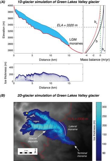
Image: In this figure we show (A) 1D model of the GLV glacier for an imposed steady state climate run out to 1000 years. Ice thickness profiles at 50-year intervals are shown in the bottom panel. Model terminus position coincides with the mapped terminal moraines. Mass balance profile for 1D model is shown on the right, where b is net mass balance, bs summer balance, and bw winter balance. The resulting ELA=3320 m, where b=0. (B) 2D model of the GLV glacier reaches the terminus position during an ELA lowering experiment when ELA = 3300 m (red solid line), which coincides well the 1D glacier results. The 2D simulation is run with a mask based on mapped glacial deposits (Madole, 1986), for example on the southern rim of the Arapaho Valley. Glacier thicknesses range from a minimum of 10 m to 320 m (see colorbar). The yellow star indicates the position of the sample GLV-2 with significant 10Be inheritance. The relatively thin ice cover at this site, and the correspondingly slow sliding speeds there, suggest that the glacier at this location should not have eroded efficiently.
-
Boulder, INVESTIGATOR
-

Boulder, INVESTIGATOR
We document the post-LGM deglaciation history of a small catchment in Colorado’s Front Range, the topmost of the 3 sub-catchments in the BcCZO, and model the glacial history responsible. We combine cosmogenic exposure dating of moraine boulders and glacial polish from ten sites down the valley axis with a set of 1-D and 2-D numerical glacier models in which climate is represented by prescribed winter and summer mass balance profiles. Moraine ages of 24-18 ka constrain the LGM maximum glacial extent at 15 km downvalley from the range crest. Glacial polish sites decline in age along the center portion of the valley, dropping to roughly 12 ka by 5 km from the crest. This supports a monotonic but non-steady decline in glacier length. Modeling of the deglaciation history reveals that the ELA rise from ~18 ka to ~14 ka was between 250-350 m, and that from ~14 ka to ~12 ka was 100-150 m. Complete deglaciation requires at least another 250-300 m of ELA rise. A transient model run employing this ELA history can both reproduce the spatio-temporal pattern of glacial polish ages, and honor the constraints on maximum glacial extent. The full deglaciation between 18 ka and 10 ka can be modeled successfully with a 4.5-6°C temperature rise and little to no change in precipitation.
From Figure 8 in Dühnforth, M., and R. S. Anderson, 2011, Reconstructing the glacial history of Green Lakes Valley, North Boulder Creek, Front Range, Colorado, using 10Be exposure dating
Publications
2011
Reconstructing the Glacial History of Green Lakes Valley, North Boulder Creek, Colorado Front Range. Duhnforth M, and Anderson, R. (2011): Arctic, Antarctic, and Alpine Research 43: 527-542
Explore Further
