MODELS
The LCZO uses conceptual, system, statistical, and process/mechanism-based models to both guide and extend our research. Our objectives are to develop new models where appropriate as well as integrate into our research existing models that are used by Luquillo LTER program and other CZO sites. In addition a major goal of the LCZO is to make physical measurements of parameters that are used in a variety of models.
Palm increases through-flow; Palo Colorado increases interception
Spatially explicit GIS based models are also a central component of LCZO efforts. These are based on a 10m DEM that is currently being upgraded with LIDAR. Raster and vector based layers of vegetation, geology, soils, and rainfall and air-temperature also exist. These models are all comparable with models that have been developed by our LTER collaborators. Topoclim (http://www.esf.edu/luq/climate/) is a spatially distributed climate model developed by the LTER group that has been used to model the distribution of evaportranspiration (Wu et al 2006,) and soil Carbon (Wang et al 2002) across the Luquillo Mountains.
Much of our ongoing modeling efforts involve developing multivariate statistical models to evaluate the influence of environmental state factors on Critical Zone structure and processes. Of particular interests is the use of Multiple Regression trees which are currently being used to ascertain the relative influence of lithology on the spatial distribution of soil organic matter and cations.
Modelling News
FEATURED
CZ colleagues: Please contact us about proposals for NSF’s CZ Collaborative Network, due 02 Dec 2019
08 Jul 2019 - CZO will end Nov 2020, succeeded by the “CZ Collaborative Network”. Let’s explore how the CZ community can build upon the CZOs via new NSF proposals.
By river, ocean, or wind, rocks round the same way
04 Apr 2018 - The milky, smooth texture of beach glass evokes a history of turbulent transport, rough edges abraded away to produce curves. The same smooth...
Water Resources Research Special Collection: Concentration-discharge relations in the critical zone
30 Oct 2017 - Water Resources Research published a new special collection in September 2017 featuring concentration-discharge research from multiple CZOs.
EOS: Taking the Pulse of the Earth’s Surface Systems
04 Dec 2015 - Taking the Pulse of the Earth's Surface Systems In September of 2014, Laurel Larsen (UC Berkley), Elizabeth Hajek (Penn State), and others...
Luquillo CZO at AGU
11 Dec 2014 - A number of posters and presentations related to work at the Luquillo-CZO will be at AGU From December 15th to December 19th.
Using a CZO network to explore the architecture, dynamics and evolution of the Critical Zone
03 Nov 2014 - The US CZO National Office has organized a webinar on December 8, 2014 at 11AM - 12:30 PM ET.
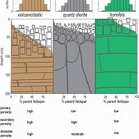
Bedrock-to-Regolith
Bedrock and Regolith Weathering
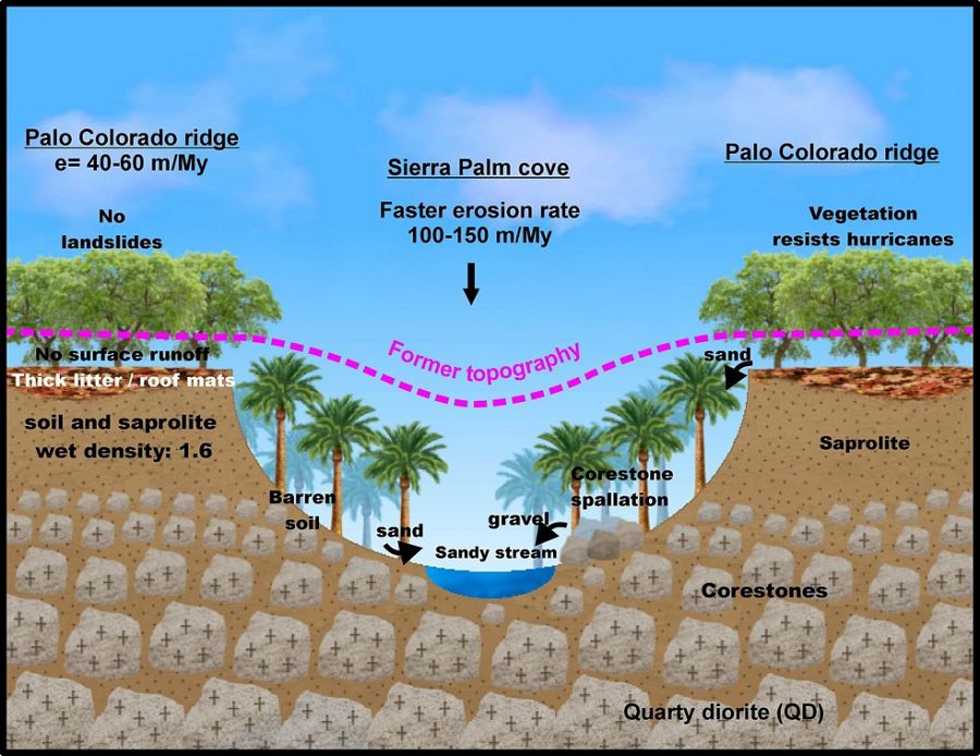
Conceptual models of deep CZ structure and function.
CENTURY
CENTURY Soil Carbon model
CENTURY Soil Carbon model has been used by the LCZO to understand the distribution of soil carbon across Luquillo watersheds.
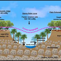
Forests/Topography
Forest Structure Effects on Topography
Rio Icacos /Rio Blanco Forest structure effects on topography
GASH
ET and Throughfall
The LCZO builds upon a long history of research on ET and throughfall.
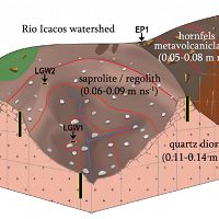
Icacos subsurface
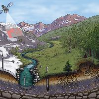
Coupling CZ structure and CZ function with observations of the physical and chemical structure.
Coupling CZ structure and CZ function with observations of the physical and chemical structure.
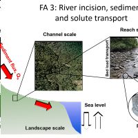
Incision/transport
River incisition, sediment and solute transport
Linking Climate and fluxes at the landscape, channel and reach scales
PHREEQC
PHREEQC
PHREEQC, stands for a “ph-redox-equilibrium-equation” model.
tRIBS
Real-time Integrated Basin Simulator -tRIBS
Real-time Integrated Basin Simulator -tRIBS
Explore Further
