Thermal hillslope
Numerical hillslope model and its thermal state
Computes evolution of topography, soil thickness, and damage in the underlying rock driven by spatial variations in the surface
Model Category:
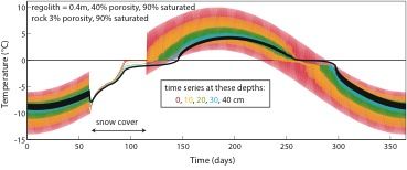
Image: In the top figure we show modeled shallow ground temperature histories at four depths over an annual cycle, starting January 1, driven by the surface temperature history (depth = 0 cm) shown. The model incorporates a two-month period of snow cover, initially with 0.4 m thickness, and temperature of -12°C at the time of deposition. The zero-curtain is clearly illustrated, during which time the latent heat associated with freezing and thaw of the water stalls propagation of the thermal wave into the ground. In the bottom two panels we show an example result of our hillslope evolution model.
-

Boulder, INVESTIGATOR
-

Boulder, INVESTIGATOR
-

Boulder, INVESTIGATOR
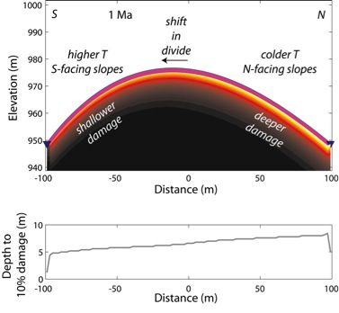
Simulated critical zone architecture after 1 Ma, with initial conditions of a triangular symmetrical interfluve centered at x=0. Resulting morphology is asymmetric, showing divide migration toward the warmer south-facing slope. More efficient transport and damage on colder north-facing slope requires lower slopes to accomplish mobile regolith transport than on warmer less efficient south-facing slopes. Mobile regolith thickness (pink layer) is nearly uniform, although it varies in time through imposed 100 ka climate. Degree of damage in weathered rock is depicted with color shading. Damage occurs to greater depths on the north-facing slopes, as depicted by the depth to weathered bedrock with 10% of the damage at the mobile regolith-weathered bedrock interface (bottom plot).
from Figures 4 and 11 in Anderson, R. S., S. P. Anderson, and G. Tucker, 2013, Rock damage and regolith transport by frost: An example of climate modulation of critical zone geomorphology
Simulated critical zone architecture after 1 Ma, with initial conditions of a triangular symmetrical interfluve centered at x=0. Resulting morphology is asymmetric, showing divide migration toward the warmer south-facing slope. More efficient transport and damage on colder north-facing slope requires lower slopes to accomplish mobile regolith transport than on warmer less efficient south-facing slopes. Mobile regolith thickness (pink layer) is nearly uniform, although it varies in time through imposed 100 ka climate. Degree of damage in weathered rock is depicted with color shading. Damage occurs to greater depths on the north-facing slopes, as depicted by the depth to weathered bedrock with 10% of the damage at the mobile regolith-weathered bedrock interface (bottom plot).
Publications
2013
Rock damage and regolith transport by frost: an example of climate modulation of the geomorphology of the critical zone. Anderson, R.S., Anderson, S.P., and Tucker, G.E. (2013): EARTH SURFACE PROCESSES AND LANDFORMS Earth Surf. Process. Landforms
Explore Further
