GIS / Remote Sensing Tag
GIS / Remote Sensing is one of more than 16 discipline tags that we use to categorize and aggregate our interdisciplinary information within and across CZOs. Much of our information has been tagged with 2-3 disciplines.
-
Catalina-Jemez People - GIS / Remote Sensing
7 People

GRAD STUDENT
.(JavaScript must be enabled to view this email address)
Hydrology, Geochemistry

STAFF, Data Manager
.(JavaScript must be enabled to view this email address)
Univ. of Arizona
spatial and temporal data analysis
 .(JavaScript must be enabled to view this email address)
Geochemistry and Soil Sciences

INVESTIGATOR, Lead-PI
.(JavaScript must be enabled to view this email address)
Univ. of Arizona
Hydrology, Geomorphology
INVESTIGATOR
.(JavaScript must be enabled to view this email address)
Environmental Physics and Mineralogy

GRAD STUDENT
.(JavaScript must be enabled to view this email address)
Univ. of Arizona
Soil science and digital soil mapping

INVESTIGATOR, PostDoc
.(JavaScript must be enabled to view this email address)
Univ. of Arizona
Fire Ecology, Semi-arid forest dynamics, Remote Sensing with LiDAR
-
-
Catalina-Jemez Data - GIS / Remote Sensing
Betasso - Topographic Carbon Storage, GIS/Map Data, LiDAR, Land Cover (2010)
2 components • Betasso • GIS / Remote Sensing, Biology / Ecology, Geomorphology, Hydrology • Tyson Lee Swetnam; Paul Brooks; Holly Barnard; Adrian Harpold; Erika GalloCatalina-Jemez - GIS/Map Data (2010-2014)
2 components • Santa Catalina Mountains, Jemez River Basin • GIS / Remote Sensing • Durcik, MatejComo Creek - Topographic Carbon Storage, GIS/Map Data, LiDAR, Land Cover (2010)
2 components • Boulder Creek Watershed • GIS / Remote Sensing, Biology / Ecology, Geomorphology, Hydrology • Tyson Lee Swetnam; Paul Brooks; Holly Barnard; Adrian Harpold; Erika GalloGordon Gulch - Topographic Carbon Storage, GIS/Map Data, LiDAR, Land Cover (2010)
2 components • Gordon Gulch • GIS / Remote Sensing, Biology / Ecology, Geomorphology, Hydrology • Tyson Lee Swetnam; Paul Brooks; Holly Barnard; Adrian Harpold; Erika GalloJemez River Basin - GIS/Map Data - EEMT-topo (2010-2011)
1 components • Jemez River Basin • Biology / Ecology, Climatology / Meteorology, GIS / Remote Sensing, Hydrology • Durcik, Matej; Rasmussen, CraigJemez River Basin - GIS/Map Data - Raster Datasets (2010-2014)
1 components • Jemez River Basin • GIS / Remote Sensing • Durcik, MatejJemez River Basin - GIS/Map Data - EEMT (2010)
1 components • Jemez River Basin • Biology / Ecology, GIS / Remote Sensing • Rasmussen, Craig; Durcik, MatejJemez River Basin - LiDAR - Post-Fire (2012)
2 components • Jemez River Basin • Geomorphology, GIS / Remote Sensing • Jon PelletierJemez River Basin - LiDAR - Terrestrial Laser Scan (2011-2013)
3 components • Jemez River Basin, Jemez 2011 Burned ZOB • GIS / Remote Sensing, Geomorphology • Caitlin Orem; Jon PelletierJemez River Basin - LiDAR - Snow-off (2010)
5 components • Jemez River Basin • GIS / Remote Sensing • Guo, Qinghua; Pelletier, Jon; Parmenter, Robert; Allen, Craig; Judy, Barbara; Durcik, MatejJemez River Basin - LiDAR - Snow-on (2010)
4 components • Jemez River Basin • GIS / Remote Sensing • Guo, Qinghua; Pelletier, Jon; Durcik, MatejNational - LiDAR, Land Cover, GIS/Map Data - OpenTopography (2010-2017)
18 components • Boulder Creek Watershed, Eel River Watershed, Jemez River Basin, Reynolds Creek Experimental Watershed, Susquehanna Shale Hills Critical Zone Observatory, Northeastern Puerto Rico and the Luquillo Mountains, Sangamon River Basin, Clear Creek Watershed, Calhoun Critical Zone Observatory, Providence Creek Headwater Catchments (1660 - 2115 m elevation) • Geomorphology, GIS / Remote Sensing, Hydrology, Biology / Ecology • National Center for Airborne Laser Mapping; Boulder Creek Critical Zone Observatory; Calhoun Critical Zone Observatory; University of Arizona; University of California Merced; Valles Caldera National Preserve; Bandelier National Monument; National Park Service; Jemez River Basin and Santa Catalina Mountains Critical Zone Observatory; Luquillo Critical Zone Observatory; Reynolds Creek CZO; Eel River CZO; Shale Hills CZOSanta Catalina Mountains - GIS/Map Data - EEMT (2010)
1 components • Santa Catalina Mountains • GIS / Remote Sensing, Biology / Ecology • Rasmussen, Craig; Durcik, Matej -
-
Catalina-Jemez Publications - GIS / Remote Sensing
2019
Long-Term (1986–2015) Crop Water Use Characterization over the Upper Rio Grande Basin of United States and Mexico Using Landsat-Based Evapotranspiration. Senay G.B., Schauer M., Velpuri N.M., Singh R.K., Kagone S., Friedrichs M., Litvak M.E., and Douglas-Mankin K.R. (2019): Remote Sensing 11(13): 1587
2018
Which way do you lean? Using slope aspect variations to understand Critical Zone processes and feedbacks. Pelletier J. D., Barron‐Gafford G. A., Gutiérrez‐Jurado H., Hinckley E.‐L. S., Istanbulluoglu E., McGuire L. A., Niu G.‐Y., Poulos M. J., Rasmussen C., Richardson P., Swetnam T. L., and Tucker G. E. (2018): Earth Surface Processes and Landforms, 43(5): 1133–1154 Cross-CZO
2017
Quantifying biomass from point clouds by connecting representations of ecosystem structure. Hendryx S.M. (2017): MS Thesis, Natural Resources, University of Arizona, Tucson, Arizona, 58 pp
2017
Soil organic carbon partitioning and Δ14C variation in desert and conifer ecosystems of southern Arizona. Lybrand R.A., Heckman K., and Rasmussen C. (2017): Biogeochemistry 134(3): 261-277
2017
Topographically driven differences in energy and water constrain climatic control on forest carbon sequestration. Swetnam T.L., Brooks P.D., Barnard H.R., Harpold A.A., and Gallo E.L. (2017): Ecosphere 8(4): e01797 Cross-CZO
2016
Constraining frequency–magnitude–area relationships for rainfall and flood discharges using radar-derived precipitation estimates: example applications in the Upper and Lower Colorado River basins, USA. Orem C.A. and Pelletier J.D. (2016): Hydrology and Earth System Sciences 20: 4483-4501
2016
The influence of Holocene vegetation changes on topography and erosion rates: a case study at Walnut Gulch Experimental Watershed, Arizona. Pelletier J. D., Nichols M. H., and Nearing M. A. (2016): Earth Surface Dynamics 4: 471-488
2016
Tree Morphologic Plasticity Explains Deviation from Metabolic Scaling Theory in Semi-Arid Conifer Forests, Southwestern USA. Swetnam T.L., O’Connor C.D., Lynch A.M. (2016): PLoS ONE 11(7): e0157582
2016
Influence of terrain aspect on water partitioning, vegetation structure, and vegetation greening in high elevation catchments in northern New Mexico. Zapata-Rios X., Brooks P.D., Troch P.A., McIntosh J. and Guo Q. (2016): Ecohydrology 9(5): 782-795 Cross-CZO National
2015
Quantifying the effects of vegetation structure on snow accumulation and ablation in mixed-conifer forests. Broxton P. D., Harpold A. A., Biederman J. A., Troch P. A., Molotch N. P., and Brooks P. D. (2015): Ecohydrology 8(6): 1073-1094 Cross-CZO
2015
Laser vision: lidar as a transformative tool to advance critical zone science. Harpold, A. A., Marshall, J. A., Lyon, S. W., Barnhart, T. B., Fisher, B. A., Donovan, M., Brubaker, K. M., Crosby, C. J., Glenn, N. F., Glennie, C. L., Kirchner, P. B., Lam, N., Mankoff, K. D., McCreight, J. L., Molotch, N. P., Musselman, K. N., Pelletier, J., Russo, T., Sangireddy, H., Sjöberg, Y., Swetnam, T., and West, N. (2015): Hydrol. Earth Syst. Sci., 19, 2881-2897 Cross-CZO National
2015
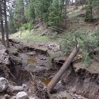
Quantifying the time scale of elevated geomorphic response following wildfires using multi-temporal LiDAR data: An example from the Las Conchas fire, Jemez Mountains, New Mexico. Orem C.A. and Pelletier J.D. (2015): Geomorphology 232: 224–238
2015
Scaling Critical Zone analysis tasks from desktop to the cloud utilizing contemporary distributed computing and data management approaches: A case study for project based learning of Cyberinfrastructure concepts. Pelletier J., Swetnam T., Merchant N., Callahan N., Lyons E. (2015): Abstract IN43B-1730 presented at 2015 Fall Meeting, AGU, San Francisco, CA, 14-18 Dec.
2015
Quantifying Topographic and Vegetation Effects on the Transfer of Energy and Mass to the Critical Zone. Rasmussen C., Pelletier J.D., Troch P.A., Swetnam T.L., and Chorover J. (2015): Vadose Zone Journal 14 (11)
2015
Topographic Control of Aboveground Carbon Pools Across an Environmental Gradient, Eastern Slope of the Rocky Mountains, Colorado. Swetnam T., Brooks P., Gallo E., Barnard H., Harpold A. (2015): Abstract H21C-1382 presented at 2015 Fall Meeting, AGU, San Francisco, CA, 14-18 Dec. Cross-CZO
2015
Discriminating disturbance from natural variation with LiDAR in semi-arid forests in the southwestern USA. Swetnam T.L., Lynch A.M., Falk D.A., Yool S.R., and Guertin D.P. (2015): Ecosphere 6(6): art97
2015
Examining the Impacts of Wildfire on Throughfall and Stemflow Chemistry and Flux at Plot and Catchment Scales. White A.M. (2015): MS Thesis in Hydrology. University of Arizona, Tucson, Arizona, 51 pp
2014
Impact of fire, landscape position, aspect, and soil depth on microbial extracellular enzyme activities in the Jemez River Basin Critical Zone Observatory. Fairbanks D., Murphy M., Frost G., Chorover J., Gallery R., Rich V. (2014): Abstract EP23B-3591 presented at 2014 Fall Meeting, AGU, San Francisco, CA, 15-19 Dec.
2014
Accessing Topographic Effects on Solar Radiation Distribution and Ecohydrological Processes. Fang Y., Niu G-Y., Troch P., Paniconi C., Durcik M., Chorover J. (2014): Abstract H51D-0642 presented at 2014 Fall Meeting, AGU, San Francisco, CA, 15-19 Dec.
2014
Spatial patterns of vegetation, soils and microtopography from terrestrial laser scanning on two semi-arid hillslopes of contrasting lithology. Harman C.J., Lohse K.A., Troch P.A., Sivapalan M. (2014): Journal of Geophysical Research: Biogeosciences 119(2): 163-180 Cross-CZO
2014
LiDAR-derived snowpack data sets from mixed conifer forests across the Western United States. Harpold, A.A., Q. Guo, N. Molotch, P. D. Brooks, R. Bales, J.C. Fernandez-Diaz, K.N. Musselman, and T.L. Swetnam, P. Kirchner, M. Meadows, J. Flanagan, R. Lucas (2014): Water Resources Research 50(3): 2749-2755 Cross-CZO
2014
Controls on the Mean Spacing of Channels on Incised Alluvial Terraces in the Western US. McGuire L. and Pelletier J. (2014): Abstract EP33B-3643 presented at 2014 Fall Meeting, AGU, San Francisco, CA, 15-19 Dec.
2014
Development of topographic asymmetry: Insights from dated cinder cones in the western United States. McGuire L.A., Pelletier J.D., and Roering J.J. (2014): Journal of Geophysical Research 119(8): 1725–1750
2014
The frequency and magnitude of flood discharges and post-wildfire erosion in the southwestern US. Orem C.A. (2014): Disertation in Geosiences. University of Arizona, Tucson, Arizona, 196 pp
2014
Update from the Papuga Lab. Papuga S.A. (2014): Catalina-Jemez CZO Meeting, Tucson, AZ, November 5, 2014
2014
Controls on Yardang Morphology: Insights from Field Measurements, Lidar Topographic Analyses, and Numerical Modeling (Invited). Pelletier J. and Kapp P. (2014): Abstract EP51F-04 presented at 2014 Fall Meeting, AGU, San Francisco, CA, 15-19 Dec.
2014
Development of High-Resolution Regolith Thickness and Topographic Datasets for Regional/Global Land-Surface Modeling. Pelletier J., Broxton P., Hazenberg P., Zeng X., Troch P., Niu G-Y., Brunke M., Gochis D. (2014): Abstract H43G-1027 presented at 2014 Fall Meeting, AGU, San Francisco, CA, 15-19 Dec.
2014
How do sediment yields from post-wildfire debris-laden flows depend on terrain slope, soil burn severity class, and drainage basin area? Insights from airborne-lidar change detection. Pelletier J.D. and Orem C.A. (2014): Earth Surface Processes and Landforms 39(13): 1822–1832
2014
Discriminating Natural Variation from Legacies of Disturbance in Semi-Arid Forests, Southwestern USA. Swetnam T., Lynch A., Falk D., Yool S., Guertin D. (2014): Abstract GC33D-0543 presented at 2014 Fall Meeting, AGU, San Francisco, CA, 15-19 Dec.
2014
Application of Metabolic Scaling Theory to reduce error in local maxima tree segmentation from aerial LiDAR. Swetnam T.L. and Falk D.A. (2014): Forest Ecology and Management 323: 158–167
2014
Estimating individual tree mid- and understory rank-size distributions from airborne laser scanning in semi-arid forests. Swetnam T.L., Falk D.A., Lynch A.M., and Yool S.R. (2014): Forest Ecology and Management 330: 271-282
2014
Understory growth dynamics following high severity burn in a mixed-conifer forest. Wilcox D., Papuga S.A. and Swetnam T. (2014): Poster presented at EarthWeek, University of Arizona, Tucson, 8-11 April 2014
2013
Using airborne and terrestrial LiDAR to quantify and monitor post-fire erosion following the Las Conchas fire, Jemez Mountains, New Mexico. Orem C.A. and Pelletier J.D. (2013): Abstract presented at Chapman Conference on Post-wildfire Runoff and Erosion Response, Estes Park, Colorado, 25 - 31 August
2013
A robust, two-parameter method for the extraction of drainage networks from high-resolution Digital Elevation Models (DEMs): Evaluation using synthetic and real-world DEMs. Pelletier J. D. (2013): Water Resources Research 49(1): 75–89
2013
Coevolution of nonlinear trends in vegetation, soils, and topography with elevation and slope aspect: A case study in the sky islands of southern Arizona. Pelletier J.D., Barron-Gafford G.A., Breshears D.D., Brooks P.D., Chorover J., Durcik M., Harman C.J., Huxman T.E., Lohse K.A., Lybrand R., Meixner T., McIntosh J.C., Papuga S.A., Rasmussen C., Schaap M., Swetnam T.L., and Troch P.A. (2013): Journal of Geophysical Research: Earth Surface 118(2): 741-758
2013
Employing lidar to detail vegetation canopy architecture for prediction of aeolian transport. Sankey J.B., D.J. Law, D.D. Breshears, S.M. Munson, and R.H. Webb (2013): Geophysical Research Letters 40: 1724–1728
2013
Cordilleran Forest Scaling Dynamics And Disturbance Regimes Quantified By Aerial LiDAR. Swetnam T.L. (2013): Disertation in Natural Resources and the Environment. University of Arizona, Tucson, Arizona, 277 pp
2012
The shifting nature of vegetation controls on peak snowpack with varying slope and aspect. Biederman J.A., Harpold A.A., Brooks P.D., Broxton P.D., Litvak M.E. (2012): Abstract C33D-0685 presented at 2012 Fall Meeting, AGU, San Francisco, Calif., 3-7 Dec (Poster). Cross-CZO
2012
Soil C and N patterns in a semiarid pinon-juniper woodland: Topography of slope and ephemeral channels add to canopy-intercanopy heterogeneity. Law D.J., Breshears D.D., Ebinger M.H., Meyer C.W., and Allen C.D. (2012): Journal of Arid Environments, 79: 20-24,
2012
Analytic solution for the morphology of a soil-mantled valley undergoing steady headward growth: Validation using case studies in southeastern Arizona. Pelletier J.D. and Perron J.T. (2012): Journal of Geophysical Research, 117: F02018
2011
Estimating Catchment-Scale Snowpack Variability in Complex Forested Terrain, Valles Caldera National Preserve, NM. A.A. Harpold, P.D. Brooks, J.A. Biederman, T. Swetnam (2011): AGU Fall Meeting Presentations Abstract C23F-05.
2011
Quantifying regional-scale ecosystem response to changes in precipitation: Not all rain is created equal. Brooks P.D., Troch P.A., Durcik M., Gallo E., and Schlegel M. (2011): Water Resources Research 47: W00J08
2011
Distinguishing grass from ground using LiDAR: Techniques and applications. Pelletier, J.D., Swetnam, T., Papuga, S.A., Nelson, K., Brooks, P.D., Harpold, A.A., Chorover , J. (2011): AGU Fall Meeting Presentations Abstract EP51E-05.
2010
Estimating large-scale evapotranspiration in arid and semi-arid systems: A multi-site study linking MODIS and Ameriflux data. Bunting, D.P., Glenn, E.P., Kurc, S.A., Scott, R.L., Nagler, P.L. (2010): AGU Fall Meeting (Poster) Abstract H31B-1000.
2010
Ecohydrological response to snowmelt dynamics from plot to regional scales. Molotch, N.P., Musselman, K.N., Trujillo, E., Brooks, P.D., McConnell, J. R., Williams, M.W. (2010): AGU Fall Meeting Abstract C14B-02. Cross-CZO
2010
Coevolution of topography, hydrology, soil development, and vegetation in sky islands of the southwestern United States. Pelletier, J.D., Rasmussen, C., Breshears, D.D., Brooks, P.D., Chorover, J., Huxman, T.E., Lohse, K.A., Meixner, T., McIntosh, J.C., Kurc, S.A., Schaap, M.G., Swetnam, T., Troch, P.A. (2010): AGU Fall Meeting Abstract EP42A-03.
2009
On the role of aspect to quantify water transit times in small mountainous catchments. Broxton P. D., Troch P. A., and Lyon S. W. (2009): Water Resources Research 45: W08427
-
Catalina-Jemez News - GIS / Remote Sensing
2016
Critical Zone Q&A with researcher Adrian Harpold
19 Oct 2016 - University of Nevada Reno's Adrian Harpold reflects on his past and present time researching at Critical Zone Observatories.
2015

Critical Zone Profile - XAVIER ZAPATA-RIOS (hydrologist, PhD student)
13 Mar 2015 - PhD Student, Hydrology and Water Resources, University of Arizona.
2014
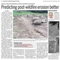
Predicting post-wildfire erosion better
08 Dec 2014 - Jon Pelletier and his graduate student Caitlin Orem's research on the post Las Conchas fire erosion was highlighed in the Arizona Daily Star...
2013
Best student presentation award
16 Sep 2013 - Congratulations to Caitlin Orem for the best student presentation award at the Chapman conference on Post-wildfire Runoff in Estes Park, CO.
2012
Jemez River LiDAR data available for download
30 Jul 2012 - Jemez River Basin LiDAR datasets (snow-on and snow-off) have been published on the OpenTopography website.
2011

Peter Troch received EGU’s John Dalton Medal 2011
01 Oct 2011 - The European Geosciences Union (EGU) has awarded the John Dalton Medal to Peter A. Troch for his seminal contributions to hydrology in the areas of...
-
Catalina-Jemez Events - GIS / Remote Sensing
Dissertation Defense
The Frequency and Magnitude of Flood Discharges and Post-wildfire Erosion in the Southwestern U.S
ENRB 253.Dissertation Defense
Cordilleran Forest Scaling Dynamics and Disturbance Regimes Quantified by Aerial LiDAR
Bannister Tree Ring Building Room 110.
Explore Further
