Swetnam et al., 2015
Topographic Control of Aboveground Carbon Pools Across an Environmental Gradient, Eastern Slope of the Rocky Mountains, Colorado
Swetnam T., Brooks P., Gallo E., Barnard H., Harpold A. (2015)
Abstract H21C-1382 presented at 2015 Fall Meeting, AGU, San Francisco, CA, 14-18 Dec. Cross-CZO
-
Catalina-Jemez, INVESTIGATOR
-
Catalina-Jemez, INVESTIGATOR
-

Boulder, INVESTIGATOR
-

Boulder, Catalina-Jemez, INVESTIGATOR
Abstract
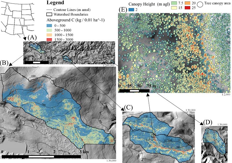
Evaluating at high spatial-resolution the topographical and ecological structures of the critical zone (CZ) are now routine with aerial LiDAR. Here we evaluated the eco-hydrological differences of topographic metrics (the independent variables) versus individual tree and gridded aboveground carbon (AGC) pools (as dependent variables) at multiple length-scales across an elevation modified gradient of precipitation and temperature in the Boulder Creek CZ Observatory Watershed, Colorado USA. We describe the responses in AGC within the context of a three-zone eco-hydrological model, e.g. toe slope and valley bottoms (Zone 1), transitional hillslopes (Zone 2), and upper slopes to ridges (Zone 3). In a GIS we compared three separate zero-order basins: (1) the Betasso Preserve: 1,810-2,024 meters above mean sea level (m aμsl), area = 0.45 km2, n = 17,286 trees; (2) Upper and Lower Gordon Gulch: 2,446-2,737 m aμsl, area = 3.57 km2, n = 178,469 trees; and (3) Como Creek: 2,900m-3,560 m aμsl, area = 6.64 km2, n = 317,274 trees. In each of the three catchments Zone 1 held the greatest mean AGC (μ = 52.88-60.97 Mg C ha-1) and maximum AGC (99% confidence interval (CI, p = 0.01) = 152.95-184.95 Mg C ha-1) relative to Zone 2 (μ = 27.84-44.52 Mg C ha-1, 99% CI = 99.67-122.4 Mg C ha-1) and Zone 3 (μ = 12.63-30.33 Mg C ha-1, 99% CI = 62.16-92.65 Mg C ha-1). Topography with negative general curvatures (i.e. convergent shapes) had greater AGC (μ = 73.7-96.3 Mg C ha-1, 99% CI = 189.0-355.8 Mg C ha-1) than positive general curvatures (i.e. divergent shapes) (μ = 17.4-30.8 Mg C ha-1, 99% CI = 88.2-120.4 Mg C ha-1), but only when evaluated at longer length scales (<10 m). Larger AGC pools are postulated to be related to (1) increased soil depth which provides larger rooting zones and (2) access to groundwater along Zone 1, vs Zones 2 and 3 which have (a) shallower soils and (b) less or zero accessibility to groundwater.
Citation
Swetnam T., Brooks P., Gallo E., Barnard H., Harpold A. (2015): Topographic Control of Aboveground Carbon Pools Across an Environmental Gradient, Eastern Slope of the Rocky Mountains, Colorado. Abstract H21C-1382 presented at 2015 Fall Meeting, AGU, San Francisco, CA, 14-18 Dec..
 This Paper/Book acknowledges NSF CZO grant support.
Explore Further
