Senay et al., 2019
Long-Term (1986–2015) Crop Water Use Characterization over the Upper Rio Grande Basin of United States and Mexico Using Landsat-Based Evapotranspiration
Senay G.B., Schauer M., Velpuri N.M., Singh R.K., Kagone S., Friedrichs M., Litvak M.E., and Douglas-Mankin K.R. (2019)
Remote Sensing 11(13): 1587
Abstract
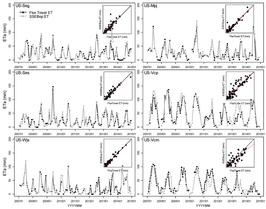
Comparison of monthly SSEBop ETa and observed ETa from the six eddy-covariance flux towers.
The evaluation of historical water use in the Upper Rio Grande Basin (URGB), United States and Mexico, using Landsat-derived actual evapotranspiration (ETa) from 1986 to 2015 is presented here as the first study of its kind to apply satellite observations to quantify long-term, basin-wide crop consumptive use in a large basin. The rich archive of Landsat imagery combined with the Operational Simplified Surface Energy Balance (SSEBop) model was used to estimate and map ETa across the basin and over irrigated fields for historical characterization of water-use dynamics. Monthly ETa estimates were evaluated using six eddy-covariance (EC) flux towers showing strong correspondence (r2 > 0.80) with reasonable error rates (root mean square error between 6 and 19 mm/month). Detailed spatiotemporal analysis using peak growing season (June–August) ETa over irrigated areas revealed declining regional crop water-use patterns throughout the basin, a trend reinforced through comparisons with gridded ETa from the Max Planck Institute (MPI). The interrelationships among seven agro-hydroclimatic variables (ETa, Normalized Difference Vegetation Index (NDVI), land surface temperature (LST), maximum air temperature (Ta), potential ET (ETo), precipitation, and runoff) are all summarized to support the assessment and context of historical water-use dynamics over 30 years in the URGB.
Citation
Senay G.B., Schauer M., Velpuri N.M., Singh R.K., Kagone S., Friedrichs M., Litvak M.E., and Douglas-Mankin K.R. (2019): Long-Term (1986–2015) Crop Water Use Characterization over the Upper Rio Grande Basin of United States and Mexico Using Landsat-Based Evapotranspiration. Remote Sensing 11(13): 1587. DOI: 10.3390/rs11131587
 This Paper/Book acknowledges NSF CZO grant support.
Explore Further
