MODELS
The conceptual model for Southern Sierra CZO involves understanding varaibles along three axes: i) elevation gradient, representing alo gradients in climate, regolith properties, soils, ecosystems, and associated processes, ii) spatial scales, and iii) temporal scales. We use a variety of numerical models, as reflected in pulications and the work plan.
Modeling overview
The conceptual model is presented in four panels, illustrated at right, and accompanying text. The panels are: Conceptual model, Processes, Spatial scales and Temporal feedbacks.
The REHSSys panel is linked to a description of one numerical model we are using, the Regional Hydro-Ecologic Simulation System.
Refer to the Conceptual and Numerical models pages for details.
Modelling News
FEATURED
CZ colleagues: Please contact us about proposals for NSF’s CZ Collaborative Network, due 02 Dec 2019
08 Jul 2019 - CZO will end Nov 2020, succeeded by the “CZ Collaborative Network”. Let’s explore how the CZ community can build upon the CZOs via new NSF proposals.
Multiple postdoc and grad student opportunities at UC Merced
12 Sep 2018 - Two postdoctoral scholar positions and multiple MS or PhD research assistantships are currently available at the University of California, Merced....
Research Program Update: September 2018
07 Sep 2018 - Recent activities and findings, funding opportunities, upcoming events, and other updates
Research Program Update: July 2018
17 Jul 2018 - Recent activities and findings, funding opportunities, upcoming events, and other updates
Research Program Updates: May 2018
27 May 2018 - Recent activities and findings, funding opportunities, upcoming events, and other updates
_200_200_80auto_s_c1.jpg)
Research Program Updates: January 2018
17 Jan 2018 - Recent activities and findings, funding opportunities, upcoming events, and other updates
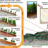
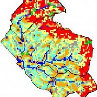
Conceptual model
Conceptual model diagram
Southern Sierra elevation and climate gradient, with spatial scaling and temporal feedbacks
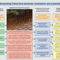
Processes
Conceptual model processes and implications
Drivers of critical zone development must be understood together to address science questions and understand implications
RHESSys
Regional Hydro-Ecologic Simulation System
A spatially distributed dynamic model of coupled eco-hydrologic processes.
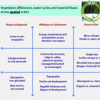
Spatial scales
Conceptual model—spatial scales
Variables important for spatial scaling of vegetation differences, water cycles and material fluxes
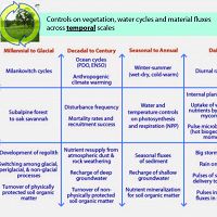
Temporal feedbacks
Feedbacks across time
Variables important for temporal feedbacks of vegetation differences, water cycles and material fluxes
Explore Further
