Conceptual model
Conceptual model diagram
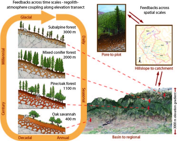
Southern Sierra elevation and climate gradient, with spatial scaling and temporal feedbacks
Model Category: Conceptual
Image: The Southern Sierra CZO involves measurements and research along a 3000-m elevation gradient, and associated gradients in climate, regolith properties, soils, vegetation and associated material cycles.
The Southern Sierra CZO is organized along an elevation transect that samples 4 ecosystems, expending from the Oak Savannah in the Sierra fothills to the subalpine forest just below the upper treeline.The 3-D elevation image is overlain with an index of vegetation, with green colors, in mixed conifer forest, being the highest vegetaion densities; and brown or white colors, in the foothills or high Sierra, being the lowest vegetation densities. The most-intensive research catchments and study sites lie in the mixed-conifer forest, as depicted by the catchment-scale map and pore-to-plot diagram. This is the elevation of the all-important rain-snow transition. Below this rain-snow-transition elevation precipitation is rain dominated, and above it snow dominated. With it Mediterranean climate the region receives precipitation mainly in the winter half year. At higher elevations snowpack storage provides an important buffer against water stress, allowing some biotic and abiotic processes to continue through summer.
Spatial scaling along this elevation gradient is also an important organizing principle for the conceptual model. The four catenas on the left illustrate important climate differences along this elevation transect, as reflected in regolith properties, soils and vegetation. CZO research aims to understand and develop a better ability to predict feedbacks across time scales.
Selection of sites along the elevation transect reflects our experimental design; by maximizing variations in climate and vegetation along an altitudinal gradient, and minimizing variations in factors such as topography and parent material within a single Batholith, we seek to hold several of the main state factors roughly constant and thus explore how sharp contrasts in the factors of interest influence critical zone processes. Each site is underlain by granitic bedrock and exhibits a similar range in topographic factors such as slope gradient, aspect, and curvature. Differences in climate across our sites are accompanied by sharp contrasts in biota and regolith properties. Biota differs both in biomass and species composition, ranging from sparsely distributed copses of stunted conifers at subalpine altitudes, to nearly continuous forests of mixed conifers and ponderosa pine at mid elevations, to spares oak-pine woodlands and grasslands in the foothills. Regolith varies both in its thickness and degree of development.
At the highest elevation site (subalpine forest catena), we observe disconnected copses of stunted conifers, which are developed on thin, patchy soils derived from weathering of both underlying bedrock and allocthonous sources (such as dust and glacial drift). Here, seasonally cold temperatures limit net primary productivity and thus evapotranspiration to short growing seasons. We hypothesize that thin, poorly developed regolith reflects either the short annual interaction between vegetation and underlying rock, an incomplete recovery from glacial conditions, or a combination of both factors.
In the mixed-conifer forest, stands of trees are fairly continuous and productivity and evapotranspiration are higher than at any other site on our transect. This appears to because of long growing seasons made possible by sustained moisture and modest temperatures at this mid-elevation site. Regolith profiles are generally thick, with high porosity in saprolite near the surface. However, patches of bare rock are common and abundant, spheroidally weathered corestones litter the surface and complicate near surface geophysical interpretations of subsurface weathering in saprolite. We hypothesize that the occurrence of patches of bare rock may reflect intrinsic contrasts in the weathering susceptibility or nutrient content among the different plutons that underlie the forest at these elevations.
Ponderosa pine forest or Ponderosa pine/oak forest
Oak/Pine woodland or Oak/Pine savanna
Explore Further
