RHESSys
Regional Hydro-Ecologic Simulation System
A spatially distributed dynamic model of coupled eco-hydrologic processes.
Model Category: Numerical
-

Sierra, INVESTIGATOR
Under construction: some raw text to consider here:
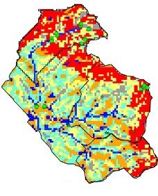
RHESSys is a GIS-based, hydro-ecological modelling framework designed to simulate carbon, water, and nutrient fluxes. By combining a set of physically-based process models and a methodology for partitioning and parameterizing the landscape, RHESSys is capable of modelling the spatial distribution and spatio-temporal interactions between different processes at the watershed scale.
RHESSys (Regional Hydro-Ecologic Simulation System) is a spatially distributed dynamic model of coupled eco-hydrologic processes. Included in the model are mechanistic representations of vertical hydrologic processes (interception, soil and litter evaporation, canopy transpiration, infiltration, vertical drainage); lateral redistribution of moisture, nutrients, and streamflow production; and soil, plant carbon, and nitrogen cycling.
The use of RHESSys as part of the SSCZO allows us to better integrate fields measurements and analysis within a spatial modeling framework. RHESSys is used to both extend estimates of eco-hydrologic variables in space and to provide estimates of eco-hydrologic variables under climate warming scenarios. A close integration of measurements and model parameterization, evaluation is a key component of this work. We use SSCZO measurements to refine RHESSys submodels and to develop efficient parameterization schemes. We also use RHESSys estimates to develop a strategic sampling design that emphasizes watershed scale responses to inter-annual climate variation and identifies gaps in current data collection.
Additional details about RHESSys can be found in Tague and Band (2004), the RHESSys website, or contact Christina Tague (email).
Explore Further
