Spatial scales
Conceptual model—spatial scales
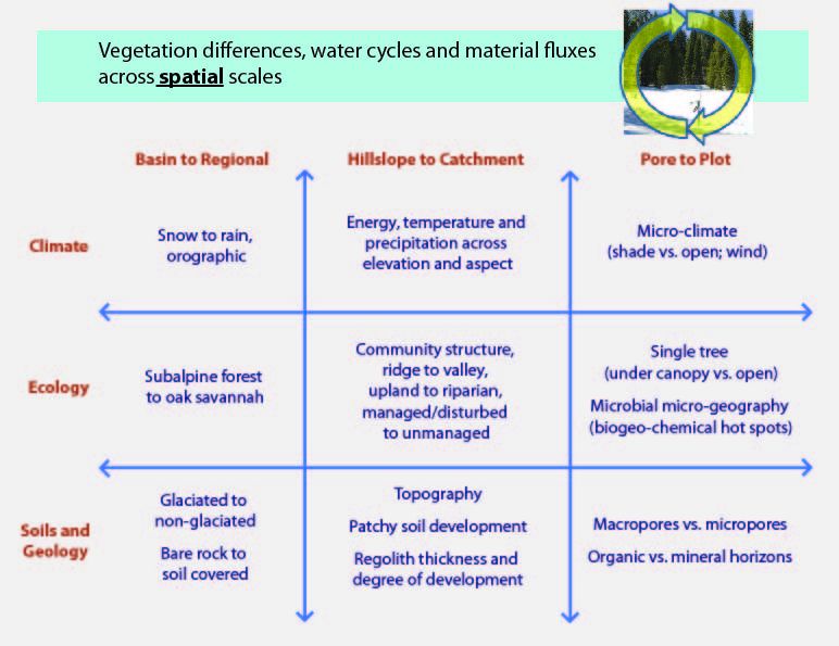
Variables important for spatial scaling of vegetation differences, water cycles and material fluxes
Model Category: Conceptual
Image: Matrix of variables important in the spatial scaling of critical zone properties
Gradients in fluxes such evapotranspiration (ET), net primary productivity (NPP), nitrification, runoff production, streamflow and sediment transport) occur at multiple spatial scales across regions, hillslopes, and plots. For example, across a region, spring runoff production may vary in consistent ways from high-elevation, snow-dominated locations to low-elevation, rain-dominated locations. At plot scales, runoff production may differ under canopy versus in the open. Observable flux gradients at each scale reflect driving mechanisms, including climatic, ecologic, and geologic processes. The relative importance of these processes varies across spatial scales and also changes with time. In the matrix above, we summarize our conceptual model of the climatic, ecologic and geologic factors that drive gradients in moisture and material fluxes at different scales. Each column represents a spatial scale and each row describes relevant climatic, ecologic, and geologic factors that influence spatial gradients across each scale. For example, regional gradients in moisture fluxes determine whether precipitation is dominated by rain or snow, whether vegetative cover is dominated by grassland or forest, whether the landscape was glaciated or not in the past, and also conditions that dominate today for soil development.
Explore Further
