Clear Creek Watershed
The Clear Creek, Iowa, watershed covers approximately 270 km2 in East Central Iowa and joins the Iowa River in Coralville, Iowa. Clear Creek is representative of most U.S. Midwestern watersheds with regards to land use (predominantly agricultural), soil type/order (Alfisols and Mollisols), and climate (humid-continental). The combination of extensive agricultural activities, increased urbanization, highly erodible soils, and a humid climate on the steep slopes within the watershed have influenced the erosion processes in the watershed.
270 km2 Area
197 - 248 m Elev
9 °C Temp
889 mm Precip
The Clear Creek watershed is characterized by low-relief landscapes, with poorly drained soils, and hydrological and biogeochemical cycles that are strongly affected by freeze-thaw cycles and artificial hydrological drainage.
Lithology
unconsolidated materials
Soil Order
Alfisol, Entisol, Inceptisol, Mollisol
Biome
grasslands, savanna
Land Use
agricultural land, urban or built-up land
-
Setting & Research
Check out our video on YouTube: “Watershed Studies: Clear Creek”
The Clear Creek Watershed was last glaciated during the Pre-Illinoian period (ca. 0.5 – 2.4 Ma) and is characterized by a dissected landscape with a well-integrated drainage network, in contrast to the areas surrounding the other IML network sites. Loess (windblown silt) thickness varies in a complex, but somewhat predictable, pattern ranging from more than 30 m in the Missouri River Valley to about 5 m in south central Iowa and 15 m in the Iowa, Cedar, and nearby Mississippi River Valleys, where Clear Creek is located. The loess overlies weathered glacial till and/or clayey paleosols. Weathered till is exposed along many of this region’s steeper slopes, and in some stream valleys, outcrops of shale, sandstone, and carbonate bedrock occur. The resulting soil patterns are complex and reflect regional and local distributions of loess, wind-blown sand, glacial till, paleosols, bedrock, and alluvium.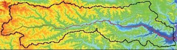
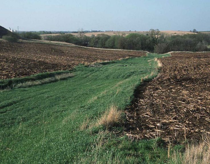
The Clear Creek Basin is a tributary of the Iowa River, draining a 270 km2 area. It is located in a region with some of the highest erosion rates in the nation.
The Clear Creek, Iowa, watershed (CCW; Fig. 4) covers approximately 270 km2 in east-central Iowa and empties into the Iowa River. Clear Creek is representative of most Midwestern watersheds regarding
soils (Mollisols), climate (humid-continental with freeze-thaw cycles), and land use (predominantly agricultural). About 0.5 million years of landscape evolution has molded the landscape into series of low-relief, rolling hills and valleys. The combination of intensive agriculture with a moist climate on highly erodible soils has dramatically decreased the time for material transport through the system, making Clear Creek a good example of the shiftfrom transformer to transporter (Abaci and Papanicolaou, 2009). Mollisols are the dominant soil order in the watershed with Alfisols, Inceptisols, and Entisols also present to a lesser extent. The most common soil associations in Clear Creek are the well-drained Tama-Downs-Fayette association in the uplands and the poorly-somewhat poorly drained Colo-Nevin-Nodaway association along the floodplains (Dideriksen et al., 2007). These loess-derived soils are highly productive due to their strong soil structure and nutrient availability (Jones et al., 1967), but are also relatively homogeneous and highly erodible. The climate in CCW is characterized by hot summers, cold winters, and wet springs with freeze-thaw periods common in late fall and early spring (Highland and Dideriksen, 1967). Average annual precipitation is approximately 889 mm with convective thunderstorms prominent in the summer and snowfall in the winter. Additionally, 50% of the annual water yield occurs in 67 days of the year, with the greatest discharges following storm events between March and June. Due to the intensive agricultural land use and stream channelization in the headwaters, the intense spring storms can result in flash floods highlighting the new role of CCW as a transporter.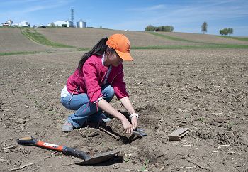
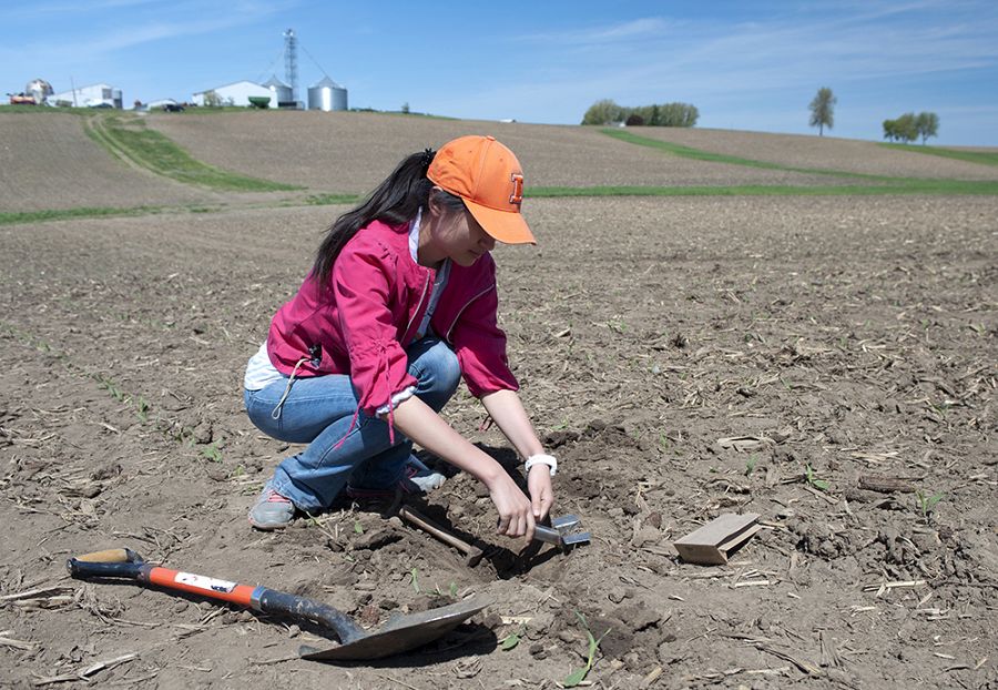
Soil sampling near South Amana, Iowa, in the Clear Creek watershed.
Detailed histories of land use (e.g., Rayburn and Schulte, 2009) and management practices (e.g., Abaci and Papanicolaou, 2009; Wilson et al., 2009) exist for the watershed. Since European settlement, more than 80% of the watershed has been converted from prairie and forests to row-crop agriculture and pastures. Parts of the watershed have also been artificially drained to facilitate infield drainage. Other recent land use changes include increasing urban and forest cover in parts of the watershed (Rayburn and Schulte, 2009). Currently, row-crop agriculture in the form of corn-soybean rotations covers 60% of the watershed, with 23% of the watershed in pasture and other grasslands, 10% under forest, and 7% in urban areas. This detailed land-use history, coupled with previous nested field studies in the watershed, will help guide our proposed observational and modeling framework of the IML-CZO through modeling simulations that can identify activity centers and isolate activity intervals.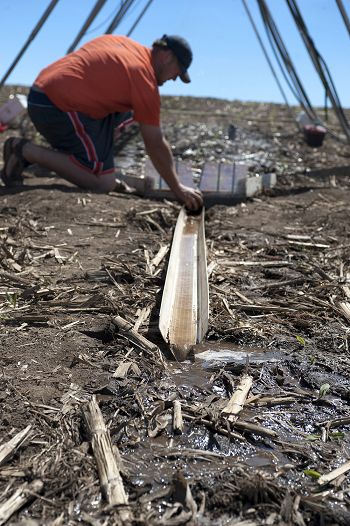
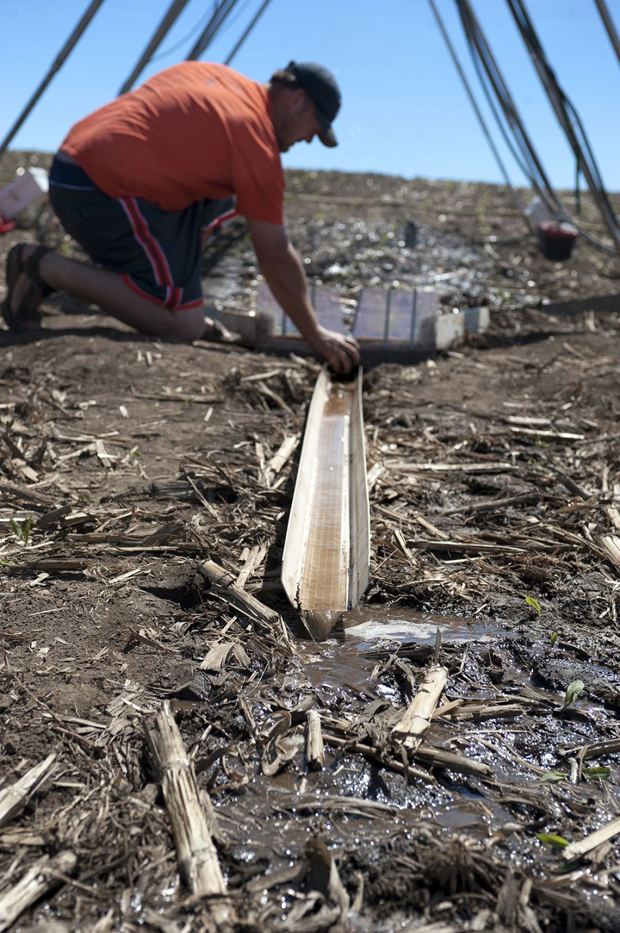
Researchers are using a rain-making machine to study sediment transport in an Iowa farm field.
Proposed study sites over a map of loess thickness. USRB is blue; CCW is red; MRB is green.
The Clear Creek Basin is a tributary of the Iowa River, draining a 270 km2 area. It is located in a region with some of the highest erosion rates in the nation.
Soil sampling near South Amana, Iowa, in the Clear Creek watershed.
Researchers are using a rain-making machine to study sediment transport in an Iowa farm field.
-
Dynamic Map
To fully zoom into a small area, you may need to visit the "Map" button and uncheck "Terrain" view.
-
Data
National - LiDAR, Land Cover, GIS/Map Data - OpenTopography (2010-2017)
18 components • Boulder Creek Watershed, Eel River Watershed, Jemez River Basin, Reynolds Creek Experimental Watershed, Susquehanna Shale Hills Critical Zone Observatory, Northeastern Puerto Rico and the Luquillo Mountains, Sangamon River Basin, Clear Creek Watershed, Calhoun Critical Zone Observatory, Providence Creek Headwater Catchments (1660 - 2115 m elevation) • Geomorphology, GIS / Remote Sensing, Hydrology, Biology / Ecology • National Center for Airborne Laser Mapping; Boulder Creek Critical Zone Observatory; Calhoun Critical Zone Observatory; University of Arizona; University of California Merced; Valles Caldera National Preserve; Bandelier National Monument; National Park Service; Jemez River Basin and Santa Catalina Mountains Critical Zone Observatory; Luquillo Critical Zone Observatory; Reynolds Creek CZO; Eel River CZO; Shale Hills CZONational - Streamflow / Discharge - USGS and USDA Data Resources (1985-2017)
22 components • Boulder Creek Watershed, Santa Catalina Mountains, Jemez River Basin, Reynolds Creek Experimental Watershed, Susquehanna Shale Hills Critical Zone Observatory, Northeastern Puerto Rico and the Luquillo Mountains, Clear Creek Watershed, Sangamon River Basin, Calhoun Critical Zone Observatory, Providence Creek Headwater Catchments (1660 - 2115 m elevation) • Hydrology • USGS National Water Information System -
Partner Organizations
-
Geology
- unconsolidated materials
The glacial legacy of the Upper Midwest has produced a geologic framework that supports a highly productive landscape. Across most of the region, the bedrock surface is buried beneath unlithified, glacial sediment that is 10 to more than 100 m thick with high lateral and vertical variability. These variations strongly influence past and present CZ processes.
The part of the Midwest that includes Clear Creek was last glaciated during the Pre-Illinoian period (ca. 0.5 – 2.4 Ma) and is characterized by a dissected landscape with a well-integrated drainage network, in contrast to the areas surrounding the other network sites. Loess thickness varies in a complex, but somewhat predictable pattern, ranging from more than 30 m in the Missouri River Valley to about 5 m in south central Iowa and 15 m in the Iowa, Cedar, and nearby Mississippi River Valleys, where Clear Creek is located. The loess overlies weathered glacial till and/or clayey paleosols. Weathered till is exposed along many of this region’s steeper slopes and in some stream valleys outcrops of shale, sandstone, and carbonate bedrock occur. The resulting soil patterns are complex and reflect regional and local distributions of loess, wind-blown sand, glacial till, paleosols, bedrock, and alluvium.
-
Topography
197 - 248 m elevation (223 m mean)
The Clear Creek watershed is typified by uplands, divided by tributary streams. The basin's floodplain is broad and wide, with a gently curving channel, except in areas where it was straightened. The land use in the watershed is dominated by intensive agriculture, with an increasingly urban portion in Johnson County, Iowa.
-
Climate
9 °C Mean Annual Temp 29 °C Mean Warmest Month -13 °C Mean Coldest Month 889 mm Mean Annual Precipitation The climate in CCW is characterized by hot summers, cold winters, and wet springs with freeze-thaw periods common in late fall and early spring. Average annual precipitation is approximately 889 mm/yr with convective thunderstorms prominent in the summer and snowfall in the winter. Additionally, 50% of the annual water yield occurs in the 67 days of the year with the greatest discharges following storm events between March and June. Due to the intensive agriculture and stream channelization in the headwaters, the intense spring storms can result in flash floods, highlighting the new role of CCW as a transporter.
-
Ecosystems
- grasslands
- savanna
Since European settlement, more than 80% of the watershed has been converted from prairie and forests to row-crop agriculture and pastures. Parts of the watershed have also been tiled to facilitate infield drainage. Other recent land use changes include increasing urban and forest cover in parts of the watershed. Currently, agriculture in the form of corn-soybean rotations cover 60% of the watershed, with 23% in pasture and other grasslands, 10% under forest, and 7% in urban areas. This detailed land use history, coupled with previous nested field studies in the watershed, will help guide our proposed observational and modeling framework of the IML-CZO through modeling simulations that can identify our activity centers and isolate our activity intervals.
-
Soil
- Alfisol
- Entisol
- Inceptisol
- Mollisol
Mollisols are the dominant soil order in the watershed with Alfisols, Inceptisols, and Entisols also present in lesser extents. The most common soil associations in Clear Creek are the well-drained Tama-Downs-Fayette association in the uplands and the poorly-somewhat poorly drained Colo-Nevin-Nodaway association along the floodplains. These loess-derived soils are highly productive due to their strong soil structure and nutrient availability, but are also relatively homogeneous and highly erodible.
-
Human Impacts
- agricultural land
- urban or built-up land
Erosion triggered by flowing water and enhanced by agriculture has re-worked the landscape into series of low-relief, rolling hills and valleys. The combination of intensive agriculture with a wet climate on highly erodible soils has dramatically decreased the time for material transport through the system, making Clear Creek a good example of the shift from transformer to transporter.
Detailed histories of land use and management practices exist for the watershed. Since European settlement, more than 80% of the watershed has been converted from prairie and forests to row-crop agriculture and pastures. Parts of the watershed have also been tiled to facilitate infield drainage. Other recent land use changes include increasing urban and forest cover in parts of the watershed. Currently, agriculture in the form of corn-soybean rotations cover 60% of the watershed, with 23% of the watershed in pasture and other grasslands, 10% under forest, and 7% in urban areas. This detailed land use history coupled with previous nested field studies in the watershed will help guide our proposed observational and modeling framework of the IML-CZO through modeling simulations that can identify our activity centers and isolate our activity intervals.
Explore Further
