Sangamon River Basin
The Sangamon River Basin includes a broad range of variations typical of the glaciated Midwest, which offer an opportunity to better understand the critical zone in this region. The basin is characterized by low-relief landscapes with poorly drained soils. The hydrological and biogeochemical cycles are strongly affected by freeze–thaw cycles and artificial drainage systems. The landscape is covered with patchy, thin loess (<1.5 m). This basin has a poorly integrated, natural drainage network with extensive areas of poorly drained soils. Weathering profiles are relatively thin and usually grade to unweathered fine-grained glacial till within 5 m of the land surface. Soil patterns generally reflect glacial depositional patterns, except where modified by stream processes in valleys.
3,690 km2 Area
180 - 291 m Elev
11 °C Temp
1000 mm Precip
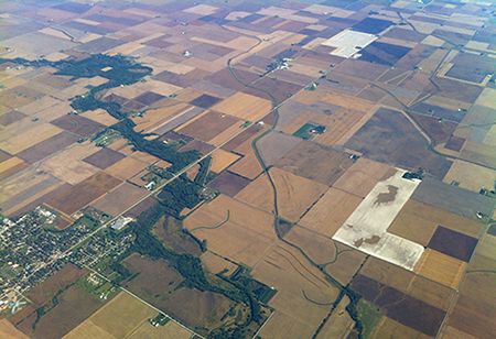
Intensively managed landscapes encompass agricultural, urban, and natural environments where human modification of the landscapes intersects with the natural legacies of the land. (Photo credit: Praveen Kumar).
Lithology
unconsolidated materials
Soil Order
Alfisol, Entisol, Inceptisol, Mollisol
Biome
grasslands, savanna
Land Use
agricultural land, urban or built-up land
-
Setting & Research
The Upper Sangamon River Basin was converted to agricultural production from native tallgrass prairie in the 1800s. Subsequently, tile installation in poorly drained soils, construction of drainage ditch systems, and channelization of headwater reaches drained seasonal wetlands and altered the hydrology and biogeochemistry of the region. The middle reaches were not excavated and retain much of their native riparian vegetation, despite increased sedimentation. Approximately 77% of the land in the basin is currently devoted to row-crop agriculture production (corn and soybeans), while developed urban areas cover 12%, grassland and forest 5% each, and 1 percent of the basin is covered with small grains production, wetlands, open water, and other uses. This diversity provides gradients in the landscape to support hypothesis testing related to spatial patterns of activity centers. Additionally, the changes in soil structure, land cover, and infield drainage, along with channel morphology, flow conditions, and sedimentary hydrogeological properties, have altered the exchange of water and water-borne solutes between streams and pore waters. These changes provide an exciting opportunity for understanding the interconnections between the landscape and the stream channel.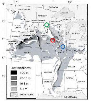
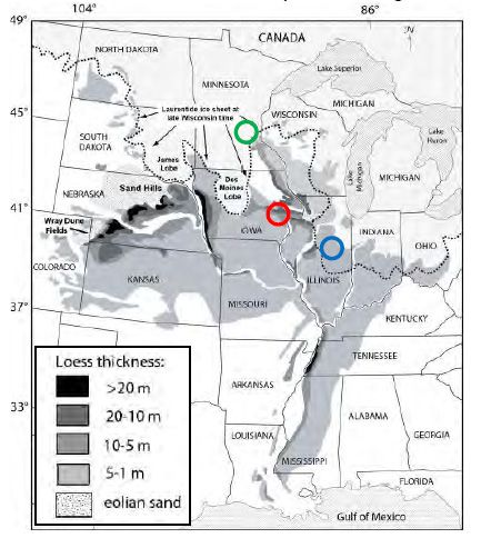
Proposed study sites over a map of loess thickness; USRB is blue, CCW is red, and MRB is green.
Proposed study sites over a map of loess thickness; USRB is blue, CCW is red, and MRB is green.
-
Dynamic Map
To fully zoom into a small area, you may need to visit the "Map" button and uncheck "Terrain" view.
-
Data
National - LiDAR, Land Cover, GIS/Map Data - OpenTopography (2010-2017)
18 components • Boulder Creek Watershed, Eel River Watershed, Jemez River Basin, Reynolds Creek Experimental Watershed, Susquehanna Shale Hills Critical Zone Observatory, Northeastern Puerto Rico and the Luquillo Mountains, Sangamon River Basin, Clear Creek Watershed, Calhoun Critical Zone Observatory, Providence Creek Headwater Catchments (1660 - 2115 m elevation) • Geomorphology, GIS / Remote Sensing, Hydrology, Biology / Ecology • National Center for Airborne Laser Mapping; Boulder Creek Critical Zone Observatory; Calhoun Critical Zone Observatory; University of Arizona; University of California Merced; Valles Caldera National Preserve; Bandelier National Monument; National Park Service; Jemez River Basin and Santa Catalina Mountains Critical Zone Observatory; Luquillo Critical Zone Observatory; Reynolds Creek CZO; Eel River CZO; Shale Hills CZONational - Streamflow / Discharge - USGS and USDA Data Resources (1985-2017)
22 components • Boulder Creek Watershed, Santa Catalina Mountains, Jemez River Basin, Reynolds Creek Experimental Watershed, Susquehanna Shale Hills Critical Zone Observatory, Northeastern Puerto Rico and the Luquillo Mountains, Clear Creek Watershed, Sangamon River Basin, Calhoun Critical Zone Observatory, Providence Creek Headwater Catchments (1660 - 2115 m elevation) • Hydrology • USGS National Water Information System
-
Geology
- unconsolidated materials
The 3,690-km2 Upper Sangamon River Basin is a well-studied watershed, representative of glaciated regions with intensive, tile drained, row-crop agriculture. The USRB drains a low-relief, loess-mantled landscape in central Illinois. Upland soils are predominantly Mollisols, which formed in medium to fine textured, calcareous, glacial till in the headwaters and in silty loess over fine-grained till downstream. Bedrock depths are 50 to 100 m below the land surface.
-
Topography
180 - 291 m elevation (239 m mean)
In the Sangamon River watershed, elevation varies from 954 feet above sea level in the headwaters of Sangamon River to 590 feet at its most downstream point at Decatur Lake. The absolute elevation changes 256 feet over the nearly 100-mile length of the Sangamon River, which translates to a stream gradient of about 2.6 feet per mile. -
Climate
11 °C Mean Annual Temp 24 °C Mean Warmest Month -5 °C Mean Coldest Month 1000 mm Mean Annual Precipitation Due to limited snow cover duration, the soils experience a high frequency of freeze-thaw cycles. Flow duration analyses indicate that 50% of the annual water yield occurs in the 40 days of the year with the greatest discharges, which usually follow storm events between March and June, thus lending justification to the experimental design that focuses on events and activity centers.
-
Ecosystems
- grasslands
- savanna
The 3,690-km2 Upper Sangamon River Basin is a well-studied watershed, representative of glaciated regions with intensive, tile drained, row-crop agriculture. The USRB drains a low-relief, loess-mantled landscape in central Illinois. It is intensively managed, following conversion to agricultural production from native tallgrass prairie in the 1800s. Subsequently, tile installation in poorly drained soils, construction of drainage ditch systems, and channelization of headwater reaches drained seasonal wetlands and altered the hydrology and biogeochemistry of the region. The middle reaches were not excavated and retain much of their native riparian vegetation, despite increased sedimentation. Approximately 77% of the land in the basin is currently devoted to row crop agriculture production (corn and soybeans), while developed urban areas cover 12%, grassland and forest cover 5% each, and 1 percent of the basin is covered with small grains production, wetlands, open water, and other uses. This diversity provides gradients in the landscape that will support hypothesis testing related to spatial patterns of activity centers. Additionally, the changes in soil structure, land cover, and infield drainage, along with channel morphology, flow conditions, and sedimentary hydrogeological properties have altered the exchange of water and water-borne solutes between streams and pore waters. These changes provide an exciting opportunity for understanding the interconnections between the landscape and the stream channel.
-
Soil
- Alfisol
- Entisol
- Inceptisol
- Mollisol
Upland soils are predominantly Mollisols, which formed in medium to fine textured, calcareous, glacial till in the headwaters and in silty loess over fine-grained till downstream.
-
Human Impacts
- agricultural land
- urban or built-up land
The USRB is intensively managed, following conversion to agricultural production from native tallgrass prairie in the 1800s. Subsequent tile installation in poorly drained soils, construction of drainage ditch systems, and channelization of headwater reaches drained seasonal wetlands and altered the hydrology and biogeochemistry of the region. The middle reaches were not excavated and retain much of their native riparian vegetation, despite increased sedimentation. Approximately 77% of the land in the basin is currently devoted to row crop agriculture production (corn and soybeans), developed urban areas cover 12%, grassland and forest cover 5% each, and 1 percent of the basin is covered with small grains production, wetlands, open water, and other uses. This diversity provides gradients in the landscape that will support hypothesis testing related to spatial patterns of activity centers.
Explore Further
