DATA - Calhoun
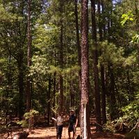
The Calhoun CZO builds on >50 years of research at the whole ecosystem level.
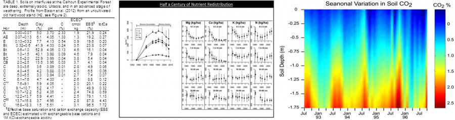
Sources: Allan Bacon, Dan Richter, 2014.
Search for Datasets
Integrated Data System
We are working with other CZOs to develop cross-CZO capabilities for sharing, integrating, analyzing, and preserving CZO data.
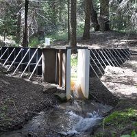
Re-instrumented catchments + Space-for-time plots + Historic records = Data for integrated models
The unique historic Calhoun data are >50-year repeated measurements of old-field soil, plants, and hydrologic responses of experimental catchments that were eroded and gullied prior to reforestation when the land was cultivated for cotton, corn, and wheat.
Some current data projects include:
1) Historic strip chart data is being digitized with help from USGS.
2) NCALM made initial leaf-on LiDAR flights over the Calhoun CZO in late July and early August 2014.
3) A monthly grab sample of seeps, streams, and rivers was initiated in July 2014. Locations were selected from across the CCZO landscape and at different elevations from the 30-plus meter weathering column.
4) 1933 Aerial photo data. High resolution black and white aerial photos have been scanned to be digitized to produce information about land use change, hydrology, energy flux, erosion rates, and biogeochemistry.
Data News
News Category: Data
FEATURED
CZ colleagues: Please contact us about proposals for NSF’s CZ Collaborative Network, due 02 Dec 2019
08 Jul 2019 - CZO will end Nov 2020, succeeded by the “CZ Collaborative Network”. Let’s explore how the CZ community can build upon the CZOs via new NSF proposals.
FEATURED
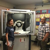
X-ray Diffraction for Clay Minerals at Calhoun
01 May 2017 - Anna Wade (visiting from Duke University) and Jay Austin (based at the University of Georgia) are collaborating by using X-ray Diffraction (XRD) to...
FEATURED
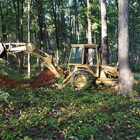
Eight new soil pits dug at the Calhoun!
17 Oct 2016 - Eight soil pits were installed at the Calhoun CZO on 17-18 October 2016 for easy access for soil sampling down to 2 meters. Photo: Will Cook.
FEATURED
Super-high res Calhoun CZO 2016 Leaf-Off LiDAR data available!
03 Oct 2016 - The February 2016 leaf-off flight covered an area of 78.3 square kilometers, less than the summer 2014 flight, but with greater point density
FEATURED
Going deep! Gas wells installed at 8.5 m
14 Jul 2016 - Another Calhoun CZO record - gas reservoirs installed at 8.5m depth! Jay Austin, Zach Brecheisen, and Dan Richter only stopped at 8.5m because they...
Water Resources Research Special Collection: Concentration-discharge relations in the critical zone
30 Oct 2017 - Water Resources Research published a new special collection in September 2017 featuring concentration-discharge research from multiple CZOs.
TDR probes installed to monitor soil moisture
13 Jul 2016 - On July 13, 2016, Duke PhD candidate Zach Brecheisen, with assistance from his advisor Dan Richter and Jay Austin, installed TDR probes at 25-cm...
EOS: Taking the Pulse of the Earth’s Surface Systems
04 Dec 2015 - Taking the Pulse of the Earth's Surface Systems In September of 2014, Laurel Larsen (UC Berkley), Elizabeth Hajek (Penn State), and others...
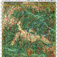
CCZO multi-layer geospatial pdf map updated!
11 Sep 2015 - Grad student Zach Brecheisen has updated this wonderful multi-layered pdf to share with other CCZO researchers.
CCZO multi-layer geospatial pdf map
13 Apr 2015 - Grad student Zach Brecheisen has created this wonderful multi-layered pdf to share with other CCZO researchers.
Data Events
Discipline Tag: Data Management / Cyberinfrastructure
1:1 Data Consultation: Calhoun CZO and CZOData team
Calhoun CZO and the CZOData team will discuss sharing data.
Online: 3-5 EDT / 2-4 CDT / 1-3 MDT / 12-2 PDT.
Explore Further
