CCZO multi-layer geospatial pdf map
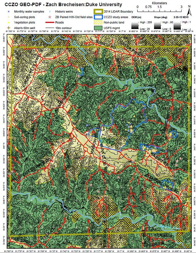
Who knew pdfs could be so versatile? For the full map (50Mb) see the link below. When opened on a GPS-capable phone/tablet, you should be able to find your exact location on the map, though we have not tested this. The map allows turning layers on/off and simple measurements of distance and area.
Methods/Experimental Design:
Map created and published in ArcGIS desktop 10.2, intended for viewing in Adobe Arcobat reader XI for windows. Datasets include roads and rivers from SC DNR; DEM, derived slope/contours, scanned 1933 aerial imagery, and land management boundaries from USFS; NAIP (2013 October) and Landsat8 datasets (2-20-15 path 17 row 36) accessed from USGS Earth Explorer; various sampling points from Will Cook imported from Google Earth.
I recommend turning off the visibility of all layers you don't want to view as you explore the map for ease of processing. Label visibility is controlled independently of feature visibility (i.e. roads & road labels). In order to take advantage of GIS capabilities imbedded, under the “edit” tab click “analysis.” The three options should include object data tool (opens model tree to view attributes and zoom to features, be sure to have turned off all non-interesting features like contours first), measuring tool (length, area, perimeter), and geospatial location tool (display coordinates, right click to find specific lat/long, can be paired with GPS in the field to find/mark your location). This is a pretty advanced draft of the map but it will be updated periodically. In particular, Will Cook and I (Zach B) will be improving the accuracy of the 1933 aerial imagery georectification/mosaicing as time permits, but it is a very useful reference and should be suitable for landscape analysis soon. The datasets in question are available upon request. Map resolution is quite good considering the 50mb file constraint for CZEN, but we may find an access means for a higher resolution version.
Field implementation with GPS location is possible with static (layer visibility is frozen, may change in future app. versions) versions of this map using Avenza’s PDF maps app for iOS and Android. Terrago has a free toolbar to extend this GPS functionality to Adobe Acrobat and is incredibly appealing but they only support this option for GEO-pdfs published using their proprietary publisher (ArcGIS option available for $3000).
News Category:
INFRASTRUCTURE |
DATA

Explore Further
