ARCHIVED CONTENT: In December 2020, the CZO program was succeeded by the Critical Zone Collaborative Network (CZ Net)
×
Super-high res Calhoun CZO 2016 Leaf-Off LiDAR data available!
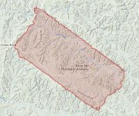
The National Center for Airborne Laser Mapping (NCALM) conducted a leaf-off LiDAR survey of the Calhoun CZO area in a single flight on February 26, 2016 (day of year 057). These data are now publicly available for downloading! See below for the dataset page with link to where you can download the data from OpenTopography.
The total lidar returns include 3.5 billion points to play with, covering an area of 78.3 km2 with 45.0 points/m2 and a raster resolution of 1 meter. For comparison, the summer 2014 leaf-on flight returned 3.1 billion points, covering 191.0 km2 with 16.1 pts/m2
News Category:
DATA
Explore Further


