High school research team visits SSCZO to study snowpack and tree canopy relationships
_900_1014_80auto.jpg)
Original article published 23 March 2016. Updated 10 May 2016.
_900_720_80auto.jpg)
Wesley Oglesby (center) measures canopy cover while Summer Olmos (left) and Raul Montejano (right) measure a sampling site's distance from the nearest tree trunk.
On Monday, March 14, a team of seven high school students conducted a research survey at the Southern Sierra Critical Zone Observatory's Providence Creek field site in the Sierra National Forest. The students and one of their instructors, Steve Wilson, were visiting from the Center for Advanced Research and Technology (CART) in Clovis, CA.
Mentored by SSCZO staff members Michelle Gilmore and Erin Stacy, the team is exploring relationships between snow depth, snowpack density, and tree canopy coverage. Snowpack density reveals how much water is contained in the snow. And tree canopy coverage is a measurement of how much of the sky is covered by tree branches, leaves, and needles. These relationships between snow and vegetation are interesting not only to this class, but also to critical zone researchers and resource managers.
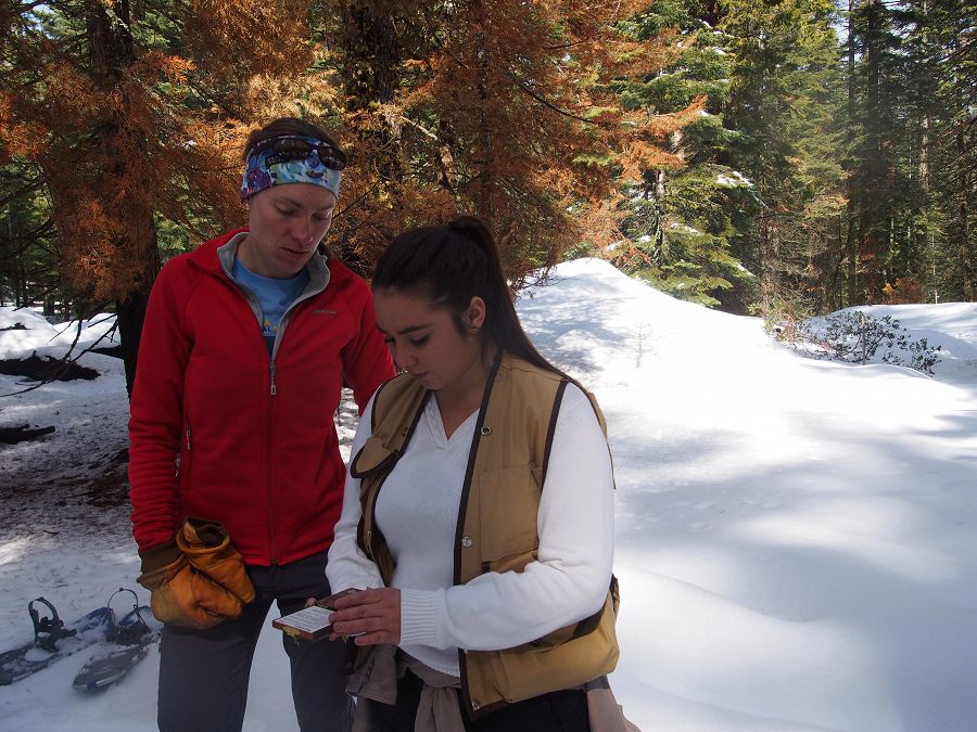
Erin Stacy watches Alexis Soto use a densiometer to measure canopy cover at a snow sampling site.
After a hike in on snowshoes, students systematically collected measurements for their study from under tree canopies, at the point where water drips off the ends of tree branches, and in open-sky gaps between trees. They gained field experience with several tools of the trade: densiometer, snow sampler, compass, and handheld GPS device.
The team made more than a few snowballs and snow angels on the hikes in and out of Providence. For some of these students, this was their first time ever in snow or in a forest.
Students will start analyzing their collected data at the end of March. They and several other teams from CART's Environmental Science and Field Research course will present their findings at a public event on May 17, 2016.
_900_1260_80auto.jpg)
Elijah Ellis records measurements and site notes on the team's data collection sheets.
10 May 2016 Update:
Through April and early May the team worked with Gilmore, Stacy, and CART teachers Staci Bynum and Steve Wilson to analyze data from their 17 sampling sites.
The students found that as canopy cover increased at Providence, snow depth and water content decreased. In open areas, average snow depth and water content in mid-March were about 10 times greater than measurements taken under tree canopies. The team also found that snow density did not follow this pattern, leading the team to believe that other factors may control snow density more than vegetation.
Students say they are excited to present their work to their families, friends, mentors, and others. Consider coming to CART on May 17 to learn about all of the projects that the Environmental Science & Field Research teams completed this semester.
Written by Michelle Gilmore
Erin Stacy watches Alexis Soto use a densiometer to measure canopy cover at a snow sampling site.
Wesley Oglesby (center) measures canopy cover while Summer Olmos (left) and Raul Montejano (right) measure a sampling site's distance from the nearest tree trunk.
Elijah Ellis records measurements and site notes on the team's data collection sheets.
News Category:
RESEARCH |
PEOPLE |
EDUCATION/OUTREACH
Partner Organizations
Discipline Tags and CZOs
Biology / Ecology
Climatology / Meteorology
Hydrology
Outreach / Education Research
Sierra
Explore Further
