California Drought Update
18 Apr 2014
The third dry year in a row has strained California water reserves, emphasizing research on how to improve water runoff quality and quantity.
Drought Situation
Now that we have come to the end of California's rainy season, the summer will be challenging. California received about 50% of average precipitation (based on long term averages). Weather stations in the Southern Sierra, where our sites are located, received an average of 41 cm (16.5") of precipitation. Only two seasons (1976-1977 and 1923-1924) in the historical record had less precipitation.With little precipitation expected before the end of the water year in September, this looks like it will be recorded as the third driest water year since record keeping began.
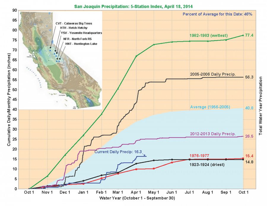
Plot of cumulative precipitation for selected water years from the California Data Exchange Center. More info available at http://cdec.water.ca.gov/.
As of April 13, automated snow sensors showed snowpack at 28% of normal. Several communities may face drinking water shortages; the State of California is helping communities face these challenges. That's not the only danger facing the state. Dry and warm conditions through the winter have raised fire danger too. Fire agencies have reported 953 fires since January 1 - that's 2.5 times as many as the year-to-date average of 377 fires. Fire fighting efforts are ramping up for a challenging summer. CALFIRE added 59 engines to the Northern California region over the past two weeks, while Southern California continues operations with 120 fire engines.
Water levels in some reservoirs have gotten so low, they threaten intakes that supply water to cities. Folsom Lake dropped to 355' in February (more information here), just above the pump intakes at 320'. Water managers all over the state have prepared contigency plans for situations like this. Luckily additional precipitation has brought the lake level up, and the reservoir elevation is now 420'. Current conditions at the majors California reservoirs are available from the California Data Exchange Center.
The Federal Government continues planning efforts as well. The U.S. Bureau of Reclamation and the Californiat Deparment of Water Resources have released a Drought Operations Plan for the remainder of the year. Agencies cooperating with the plan implementation include U.S. Fish and Wildlife Service, National Marine Fisheries Service, California Department of Firsh and Wildlife, and the State Water Resources Control Board. Further information, including more recent updates based on incoming data, are available at drought.ca.gov. Information presented here is based largely on the Weekly Drought Brief published by the State and on information from the Department of Water Resources site.
Research at SSCZO sites
A large part of research at the SSCZO pursues changing rain-snow dynamics. Looking across a large elevation gradient (from 400 m to 2700 m) we are investigating how the water balance changes with different climate and vegetation parameters. Those field measurements feed models that we use to manipulate forest density, evapotranspiration, temperature, and other factors. In turn, model results inform management decisions.
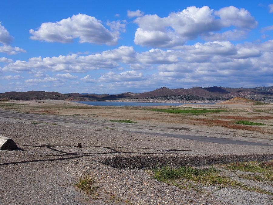
Instead of the generally snowy cover at Providence, much of the winter looked like this snow-free shot from January.
This winter, we saw very dry conditions at the SSCZO sites. While snow normally melts out several times per winter at Providence, this year it was even more intermittent than usually. The Providence Creek catchment is our third highest in elevation at 2015 m. Snow at Soaproot Saddle (1160 m) is even less enduring, and more of the precipitation falls as rain.
A great example of the intermittent snowpack can be seen at the CZTree-1 in these time-lapse videos: winter 08-09, 09-10, 10-11, 11-12, and 12-13. In 2014, occasional storms brought snow in late January-February, and late March-early April, but much of the winter was dry. Many mid-elevation areas were without snow for extended periods of time.
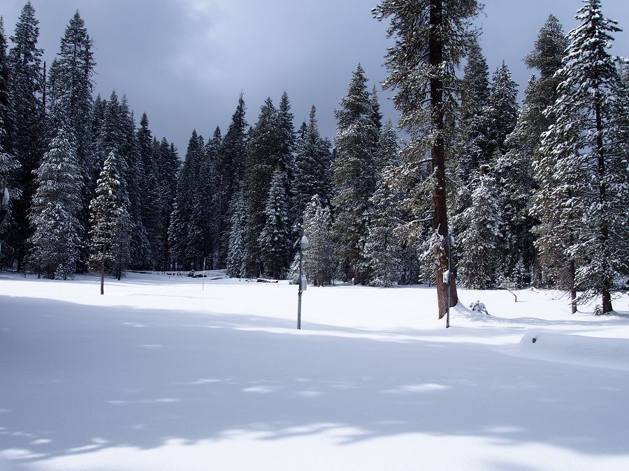
Two late winter storms covered the P301 meadow with snow on Mar 27 and April 1. The snowpack started melting rapidly after those two storms.
Across these elevations we have installed flux towers where we track exchanges of carbon dioxide and water vapor between the land/vegetation and the atmosphere. By watching the forest breathe in this way, we can tell when the forests are active, and how the current drought is affecting forest activity. Previous work led to the hypothesis that deep soil water storage provides the water for evapotranspiration through dry summers. However, it looks as though that pool of water (in the soil and deep regolith) is emptying, with remaining water becoming less accessible to vegetation. Evapotranspiration is being curtailed year-over-year, concurrent with drier soils.
At the Providence field area, our research partners at the Pacific Southwest Research station are investigating the effects of prescribed burns and mechanical thinning on water runoff quantity and quality. The project, called the Kings River Experimental Watersheds, has been going on since 2002. The thinning around the Providence tower was completed in 2012 and 2013, and we are tracking its impact on forest evapotranspiration at the flux tower. The Southern Sierra Critical Zone Observatory is part of a larger regional effort at the Sierra Nevada Research Institute at UC Merced. Other projects at the Sierra Nevada Research Institute include a series of sites instrumented with wireless sensor networks in the American River Basin, and a partnership with the Forest Service at the Stanislaus-Tuolumne Experimental Forest. Another long-term project, the 7-year Sierra Nevada Adaptive Management Project (also known as SNAMP) wraps up this year. Final reports from the SNAMP project are being published throughout the rest of the year. Among the major drivers behind these projects are ways to improve our knowledge and real-time information for the California water system.
Looking forward
Information is one of the most flexible and accessible parts or our water system to improve. Other components of the water system in California are infrastructure and institutions. Infrastructure would require major investments, but more storage does not help in years like this, where we have an excess of storage capacity for the amount of water. Institutions can be flexible, but to alter some parts would require changing legislation. Ultimately, success will require careful coordination of the three components. From the research end, we share our results through discussions with policy makers, resource managers, and other stakeholders.
At the upcoming UC Drought Science, Policy and Management Summit, UC Merced faculty Joshua Viers and Roger Bales will participate in a panel. The Drought Summit will be held on April 25th at our state Capitol. It is free and open to the public, though registration is required.
We participate in a collaborative forest planning effort on part of the Sierra National Forest called the Dinkey Landscape Restoration Project. At the May 15th meeting, there will be a panel with updates on water from the SSCZO and Kings River Experimental Watersheds. This Water Panel will be part of the regular DLRP Collaborative meeting in Fresno, but it is free and open to the public. If you are interested, please check with Erin Stacy for more information.
Upcoming SNAMP events may be of interest to the water resource community too: (1) a Rim Fire Field Trip on June 19, and Integration Team meetings on (2) Fire and Forest Ecosystem Health (May 15) and (3) Water (September 4). These events are open to the public; more information is available from the SNAMP calendar.
Plot of cumulative precipitation for selected water years from the California Data Exchange Center. More info available at http://cdec.water.ca.gov/.
Two late winter storms covered the P301 meadow with snow on Mar 27 and April 1. The snowpack started melting rapidly after those two storms.
Instead of the generally snowy cover at Providence, much of the winter looked like this snow-free shot from January.
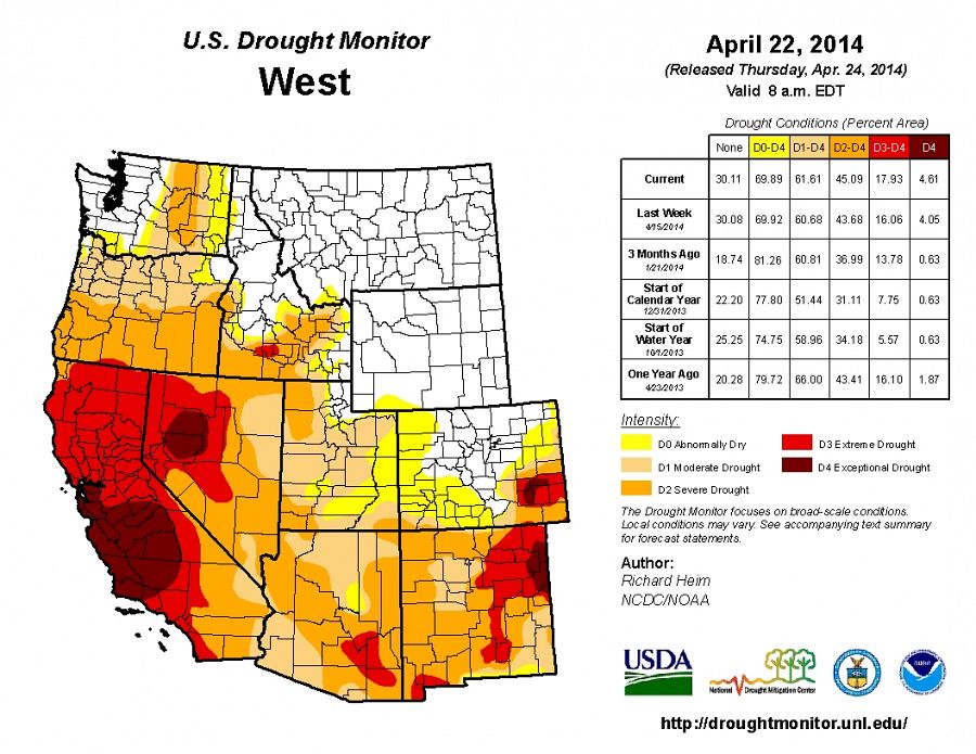
As of April 22, all of California is classified with some level of drought, according to the US Drought Monitor.
News Category:
RESEARCH |
EDUCATION/OUTREACH
Explore Further
