Icacos subsurface
Coupling CZ structure and CZ function with observations of the physical and chemical structure.
Coupling CZ structure and CZ function with observations of the physical and chemical structure.
Model Category: Conceptual
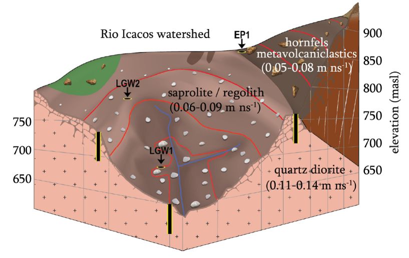
Image: Conceptual model of the subsurface of the Rio Icacos watershed that includes drilling locations and range of electromagnetic (EM) wave velocity for each material. Figure 9. Orlando et. al., 2016. DOI: 10.1002/esp.3948
-

Luquillo, GRAD STUDENT
-

Luquillo, Shale Hills, INVESTIGATOR, COLLABORATOR
-

Luquillo, Shale Hills, INVESTIGATOR
-

Luquillo, INVESTIGATOR
-

National, Eel, Luquillo, Shale Hills, INVESTIGATOR, COLLABORATOR
To put these results in context, we summarize the differences observed in composition and thickness of drilled borehole profiles with respect to watershed position in Table 1 and Figure 9. Topographically higher in the watershed or further from the knickpoint we observed: (1) the percentage of competent rock recovered from the borehole is lower; (2) the number of fractures detected in intact rock recovered from the borehole is lower; (3) the range in variation in water table elevation is higher. Furthermore, both borehole measurements and GPR results show that when regolith is present, its thickness generally increases from lower to higher elevations and with increasing distance from the knickpoint. Finally, the highest density of fractures in each borehole is located near the bedrock–regolith interface. Figure 9 sums up these trends in a schematic. In Figure 9, the knickpoint occurs just below LGW1 along the river profile. As depicted in Figure 9 based on drilling, the bedrock–regolith interface as we have observed it more or less parallels the land surface, except that the regolith depth generally increases toward the upper elevations, as does the depth to the water table.
Publications
2016
Architecture of the deep critical zone in the Río Icacos watershed (Luquillo Critical Zone Observatory, Puerto Rico) inferred from drilling and ground penetrating radar (GPR). Joe Orlando, Xavier Comas, Scott Hynek, Heather L. Buss, and Sue L. Brantley (2016): Earth Surface Processes and Landforms
Explore Further
