Ecohydrology and Hydrologic Partitioning
Vegetation, soils, landform morphology, and bedrock play key roles in the partitioning of precipitation into canopy interception, infiltration, storage, soil evaporation, sublimation, plant transpiration, recharge, runoff, and stream flow. Hydrologic flow paths also feed back to affect vegetation structure, microbial community development, soil formation and hydraulic characteristics, landform morphology, mineral surface areas, and carbon transport. This theme is organized to capture these linkages between hydrology and CZ evolution.
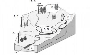
Image: Conceptual figure representing the locations of research projects presented in the papers of this special issue. Study sites generally were located within nested catchmnets spanning an elevation gradient from subalpine fir at the highest elevations to pinyon-juniper at lower elevations. (a) McDowell et al., (b) Small and McConnell, (c) Lyon et.al., Vivoni et al., (e) Liu et al., (g) Mahmood and Vivoni.
This group is tagged with:
-
The partitioning of precipitation into interception, throughflow, infiltration, storage, evaporation, sublimation, transpiration, recharge, runoff, and stream flow is intimately linked to critical zone structure. Water stores and fluxes are both drivers of CZ evolution and a function of CZ development with feedbacks between vegetation, soil, landform, and bedrock. Within the EEMT framework that unifies work on the JSC CZO, water is a both direct driver of CZ development and an indirect driver that constrains carbon cycling and chemical energy for weathering reactions. Hydrologic flow paths also feedback to affect vegetation structure, microbial community development, soil formation and hydraulic characteristics, landform morphology, mineral surface areas, and carbon transport. Our EHP theme is designed to quantify these multi-scale and multidisciplinary linkages between the water cycle and CZ evolution.
Current research foci include:
- Quantifying spatial and temporal variability in total precipitation inputs, including rain and snow
- Quantifying spatial and temporal variability in sublimation and net snow water inputs
- Identifying water sources for vegetation
- Understanding species differences in water use and response to changes in precipitation
- Identifying feedbacks between vegetation structure and evaporation vs transpirative fluxes
- Quantify topographically-driven hydrologic subsidy (or deficit) and Effective Precipitation (Peff) available to plants
- Quantifying spatial and temporal variability in GPP, NEE, and soil carbon inputs
- Quantifying the sensitivity of soil respiration to changes in climate, especially water availabilit
Observations range in scale from individual trees, plots, and hillslopes in our intensively studied ZOBs, to eddy covariance towers that capture water and carbon fluxes at ~1km2, to airborne and space-based remote sensing of vegetation and hydrologic states.Similar to much of the western US, snow is a critical driver of CZ evolution in both the JRB and SCM sites and significant efforts have been made at understanding the distribution and fate of seasonal snowpacks.
Snow cover typically is ephemeral at our SCM sites accumulating and ablating multiple times over the course of a typical winter. In contrast, snow cover typically is continuous from late November through mid April at our JRB sites. Although seemingly subtle, this difference between the sites has significant effects on soil frost, hydrologic partitioning, carbon cycling and nutrient availability that are being explored by CZO students.
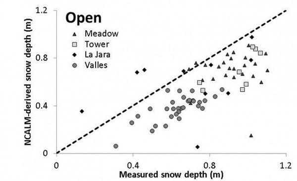
A comparison between snow on and snow off LiDAR flights in 2010 has quantified the spatial variability in snow depth at our JRB sites. Notably, LiDAR consistently underestimates snow depth when compared to contemporaneous manual observations. These differences appear to result from spatial variability in ground cover that complicates identification of the land surface and is a point of ongoing research at our and other CZO sites.
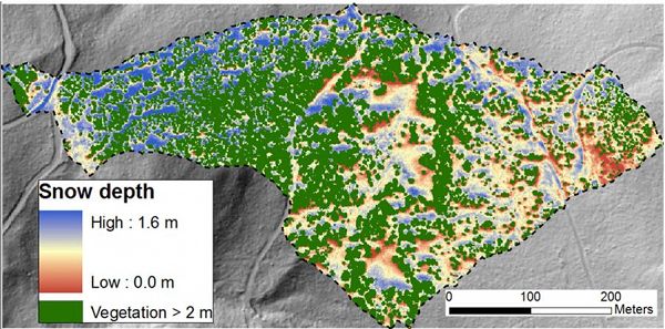
Snow depth from LiDAR flights in our intensive mixed conifer zero order basin reveals structure associated with vegetation and aspect which together protect snow surface from solar radiation and minimize sublimation over winter (Mussleman et al. 2008, Veatch et al 2009. Rinehart et al 2009, Gustafson et al. 2010).
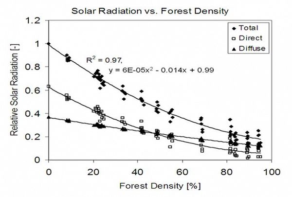
Data from Veatch et al. (2009) quantifies the relationship between forest canopy cover and solar radiation reaching the snowpack.
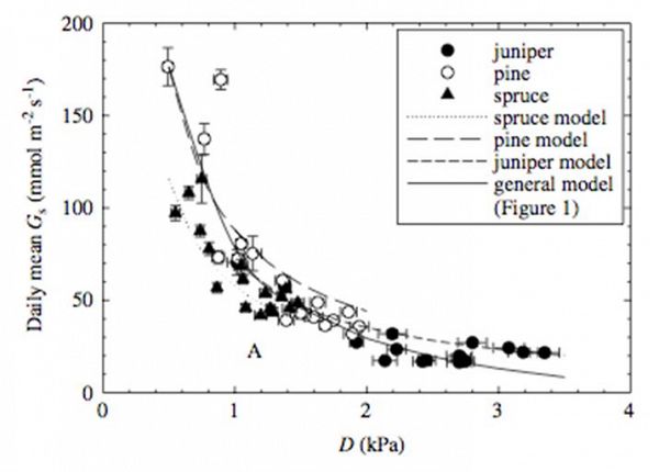
A simple model of plant hydraulic conductance relates crown scale stomatal conductance (Gs) as a function of vapor pressure deficit across the elevation gradient in the JRB CZO sites demonstrates the interaction between climate, plant physiology, and ecosystem structure in regulating transpiration flux across steep climate gradients (McDowell et al. 2008).
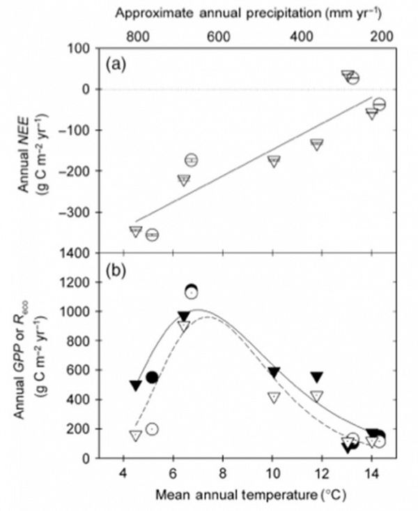
Annual carbon fluxes for two years as a function of temperature and precipitation across an elevation gradient in NM (Solid symbols are GPP, hollow symbols are Reco). The two coldest, wettest sites are intensive study sites of the JRB CZO that, together with lower elevations sites, suggest that respiration (Reco) is more sensitive to temperature than GPP (Anderson-Teixeira, et al. 2011).
-
Contacts
-
Catalina-Jemez, INVESTIGATOR
-
Catalina-Jemez, INVESTIGATOR
15 People
INVESTIGATOR
.(JavaScript must be enabled to view this email address)
Ecohydrological implications of environmental and climatic change on semiarid ecosystem functioning
INVESTIGATOR
.(JavaScript must be enabled to view this email address)
Univ. of Arizona
Dryland Ecohydrology, Vegetation Gradients and Global Change, Tree Die-off
INVESTIGATOR
.(JavaScript must be enabled to view this email address)
Hydrology, biogeochemistry, terrestrial and aquatic ecosystems
GRAD STUDENT
.(JavaScript must be enabled to view this email address)
Univ. of Arizona
Hydrology, Flow and transport in hydrological systems, Geochemistry
INVESTIGATOR
.(JavaScript must be enabled to view this email address)
Univ. of Arizona
Hydrology, Geophysics
UNDERGRAD
.(JavaScript must be enabled to view this email address)
Univ. of Arizona
phenology, soil moisture, meteorology
INVESTIGATOR, COLLABORATOR
.(JavaScript must be enabled to view this email address)
Ecohydrology, Ecophysiology
STAFF, Field Manager
.(JavaScript must be enabled to view this email address)
Geography, Climatology
GRAD STUDENT
.(JavaScript must be enabled to view this email address)
Univ. of Arizona
Climate, Plant physiology
INVESTIGATOR, COLLABORATOR
.(JavaScript must be enabled to view this email address)
Biosphere 2
Hydrologic modeling
INVESTIGATOR
.(JavaScript must be enabled to view this email address)
Terrestrial hydrology and biometeorology
GRAD STUDENT
.(JavaScript must be enabled to view this email address)
Univ. of Arizona
Hydrology, Geophysics
INVESTIGATOR
.(JavaScript must be enabled to view this email address)
Univ. of Arizona
Hydrology
INVESTIGATOR, Visiting/Affiliate
.(JavaScript must be enabled to view this email address)
Hydrology
Alumni-Former
INVESTIGATOR, PostDoc
.(JavaScript must be enabled to view this email address)
ecosystems and climate change
UNDERGRAD
.(JavaScript must be enabled to view this email address)
Univ. of Arizona
Understory Phenology; LiDAR; meteorological data; soil moisture data
-
Explore Further
