Fresh landslides triggered during September’s deluge

Heavy Rainfall and the Geomorphic Response
During the week of September 9th, 2013, several days of continuous rainfall caused widespread landslides and flooding in the northern Colorado Front Range. Based on ground and aerial reconnaissance, the USGS Landslide Hazards Group have forecasted that areas where soil and rock were disturbed by the rainfall, especially steep slopes, are likely to be susceptible to catastrophic failure during rainstorms and snowmelt for several years.
In the City of Boulder, landslides and debris flows were triggered along the slopes lining the western margin of the city, damaging several homes, and killing two young adults. Particularly visible from town are slides on grassy slopes along the sandstone/shale contact on Dakota Ridge. Several mountain communities in the Front Range were severely impacted by debris flows, and several of the eight deaths in the storm are attributed to landslides and debris flows (USGS landslides report).
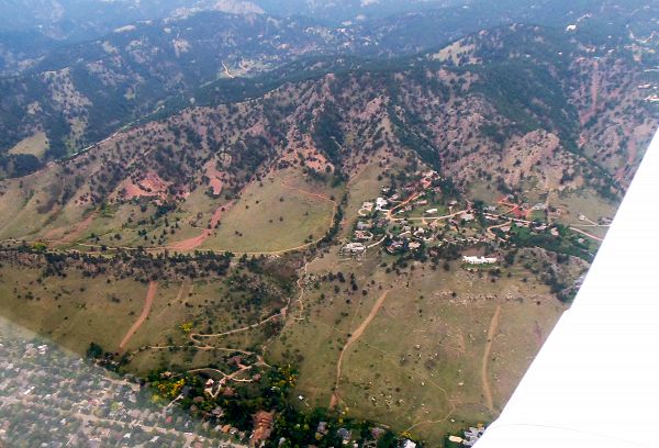
Fig. 1. This aerial shot shows the debris flows that line the Dakota hogback in the foreground and Mount Sanitas behind it (Photo courtesy of Nate Rock, dated October 3, 2016).
What Makes it a Landslide versus a Debris Flow?
Landslides occur when discrete masses of earth slide downhill after failing along a shear zone. According to Johnson (1984), debris flows most often form when a landslide partially or completely mobilizes into a debris flow. Debris flows pose considerable hazards because of the high speeds possible and long distances flows can cover. Heavy rains are likely to trigger debris flows because the water flowing down slopes helps fluidize failed materials. For instance, in a single intense rainstorm in July 1999, some 80 debris flows occurred in a small area near Loveland Pass in central Colorado, one of which inundated Interstate 70 (see USGS report on 1999 I-70 Debris Flow, includes photos and map).

Fig. 2. This is a complex of shallow landslides that is located to the west and upslope of Wonderland Lake in north Boulder. These slides evolved into mudflows allowing long distance downslope transport of rocks as large as 30 cm in diameter. In the foreground, one can see that clumps of grass remain in the path of the flow, meaning that the flow did not scour to the bed here. The person in the distance (center of the photo, in blue) is standing above a site where two slides/flows merged. The small scale wrinkle in the landscape below him served as a ponding site for the material, only a small fraction of which spilled over the top to go further downhill. (Photo by Robert S. Anderson).
Boulder CZO Takes Action:
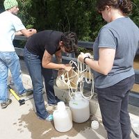
Just days after the storm, Boulder Creek CZO investigators ventured out to examine, photograph, and measure the landslides on the slopes of the Dakota Hogback in north Boulder. It appeared that the landslides were initiated a sites where the topography had focused water flow, both on the surface and in the ground. The slopes failed during or after the heaviest rains, presumably when the hillslope materials would have been fully saturated. The failures appeared to have started as relatively minor slips or rotational slides. Since the materials were so wet, the failures evolved slurries or debris flows, which promoted their ability to travel long distances downslope. The following maps and photographs document the CZO investigators observations.

Fig. 3. This shaded relief map shows the locations of fresh landslides (green dots) along the eastern side of Dakota Ridge in the foothills to the west of Boulder. Note how the landslides in this area occurred consistently along a particular bedrock boundary and topographic setting. In a reconnaissance survey by the USGS Landslide Hazards Group found that failures were triggered in a wide range of environments, from the High Plains to alpine slopes, and in soils developed in rocks ranging from Paleozoic shales and sandstones to PreCambrian granites and gneisses (see full report).
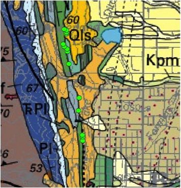
Fig. 4. This bedrock geology map shows the variety of rock types or lithologies in the Boulder area. New landslides are shown as green dots. The landslides consistently orginated at along a shale/sandstone boundary.
Map Legend:
Yellow (Qls): Landslide deposits, Holocene/Upper Pleistocene
Orange: Colluvium, Holocene/Upper Pleistocene
Turquoise/light blue: Benton shale
Green: Dakota Group or sandstone
Ocean Blue: Morrison Sandstone

Fig. 5. This is a large headscarp of a landslide on the slope to the west of Forrest St. in Boulder. The headscarp is at a sandstone/shale contact. This headscarp is 1.5m high, 9m long, and 8m wide. The bottom of the headscarp sits about 10 m below the level where sandstone outrcops. Sand was prevalent and organic material was missing in the cut exposed by the headscarp. There were signs of overland flow (flowing water on the surface) on the sides of headscarp. (Photo by Eric Winchell, dated Sept. 20, 2013).
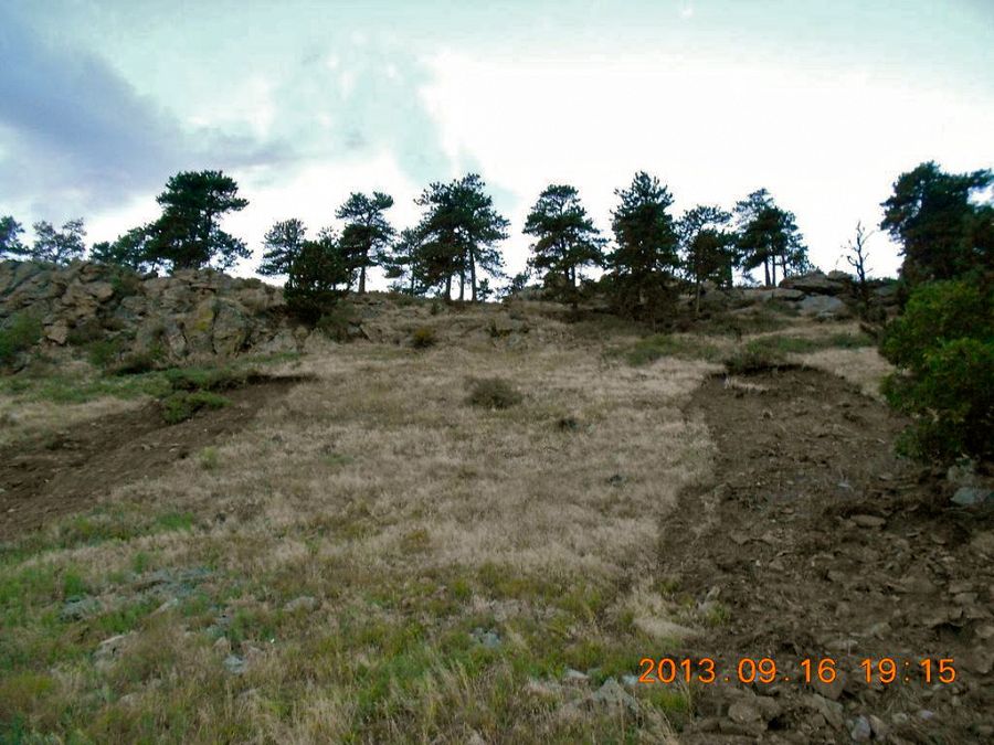
Fig. 6. This photo from Sept. 16, 2013, shows two landslides that occurred in close proximity to each other. (Photo by Eric Winchell).
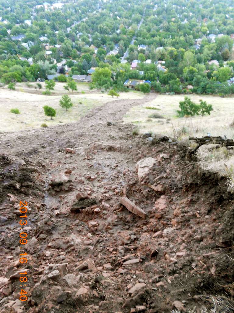
Fig. 7. The largest landslide flowed ~150 m downslope and hit a house near Forest Ave in north Boulder. The landslide had quite a uniform width along its length. At the time of this photo, Sept. 16, 2013, water was seeping out of the headscarp and for another ~25 downslope (see photo). The headscarp exposes sandstone, which is likely the Dakota Sandstone. (Photo by Eric Winchell).
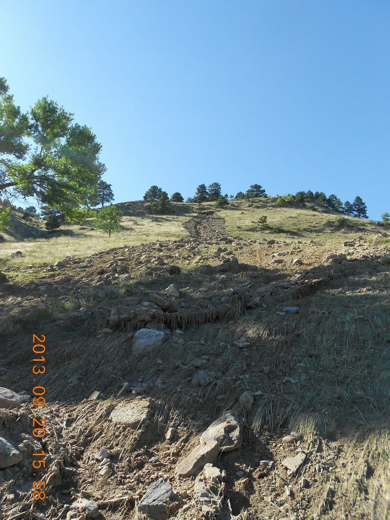
Fig. 8. Looking up at the scar of the debris flow also shown in Figure 7. Note that the grass is still present in the path of the flow (Photo by Eric Winchell). Slope saturation by water is a primary cause of landslides. In this area, the source of the water comes in the form of intense rainfall, snowmelt, changes in ground-water levels, or a combination of those. Landsliding and flooding are closely connected because both are related to precipitation, runoff, and the saturation of ground by water.
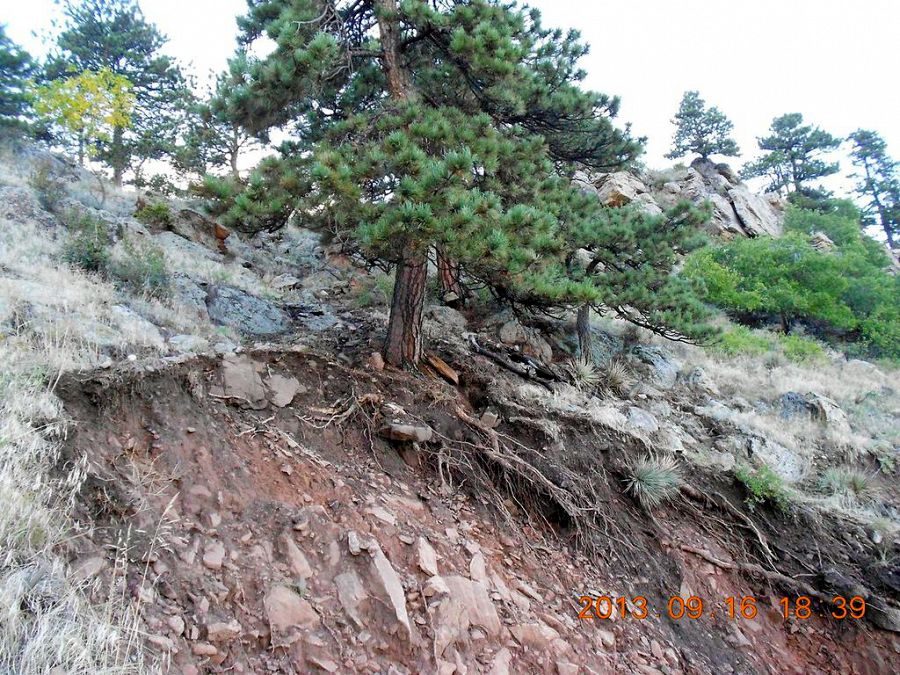
Fig. 9. The headscarp of one landslide, which revealed the roots of this tree. (Photo by Eric Winchell).
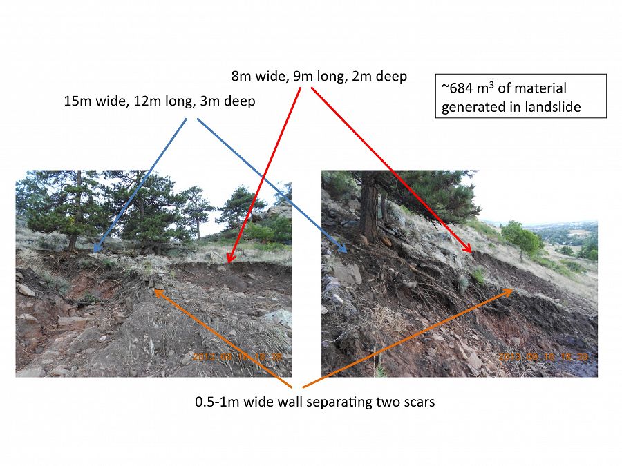
Fig. 10. These two landslides are separated only by a ~1 m wall of sediment. (Photo by Eric Winchell, Sept. 16, 2013).
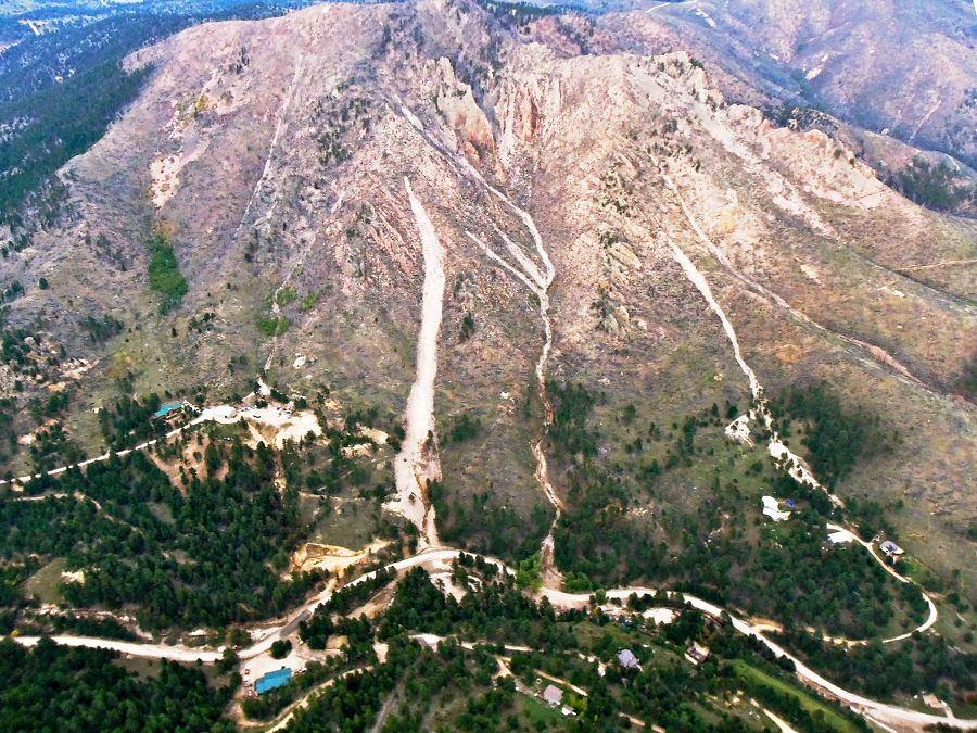
Fig. 11. Aerial view of debris flows on Porphyry Mountain west of Jamestown, Colorado. Porphyry Mountain is a quartz monzonite porplyry intrusion into heavily faulted PreCambrian rocks (Photo by Nate Rock, Oct. 3, 2013).
Relevant Links for Eductional and Research Purposes
USGS Landslide page - With a link to a report on the effects of this storm on landslides in Colorado
Landslide Hazards Information page - With diagrams of different kinds of landslides and flows, and a video.
AGU Landslide blog by Dave Petley - Case studies with fantastic images of landslides around the world and throughout time.
Five killed in landslide SW of Denver, Sept. 30, 2013 - A news report on a large landslide near Mt. Princeton.
USGS article on Colorado debris flows in I-70 corridor, 1999 - USGS web page with a case study with maps, photos, and description of conditions and characteristics.
Videos of debris flows for teaching (Links to free videos)
Resource page for K-12 teachers on teaching about landslides (Highly recommended)
Make Your Own Landslide - Activity page
Landslides and Debris Flows Induced by Rainfall - A research article by Ronaldo I. Borja from Stanford University.
Landslides and Avalanches page - University of Colorado at Boulder Hazards Center
References
Johnson, A. M. (1984) Debris Flow. In: Brunsden, B. and Prior, D. B. (eds.) Slope Instability. Chichester: Wiley, pp. 257–361.
Fig. 1. This aerial shot shows the debris flows that line the Dakota hogback in the foreground and Mount Sanitas behind it (Photo courtesy of Nate Rock, dated October 3, 2016).
Fig. 3. This shaded relief map shows the locations of fresh landslides (green dots) along the eastern side of Dakota Ridge in the foothills to the west of Boulder. Note how the landslides in this area occurred consistently along a particular bedrock boundary and topographic setting. In a reconnaissance survey by the USGS Landslide Hazards Group found that failures were triggered in a wide range of environments, from the High Plains to alpine slopes, and in soils developed in rocks ranging from Paleozoic shales and sandstones to PreCambrian granites and gneisses (see full report).
Fig. 4. This bedrock geology map shows the variety of rock types or lithologies in the Boulder area. New landslides are shown as green dots. The landslides consistently orginated at along a shale/sandstone boundary.
Map Legend:
Yellow (Qls): Landslide deposits, Holocene/Upper Pleistocene
Orange: Colluvium, Holocene/Upper Pleistocene
Turquoise/light blue: Benton shale
Green: Dakota Group or sandstone
Ocean Blue: Morrison Sandstone
Fig. 2. This is a complex of shallow landslides that is located to the west and upslope of Wonderland Lake in north Boulder. These slides evolved into mudflows allowing long distance downslope transport of rocks as large as 30 cm in diameter. In the foreground, one can see that clumps of grass remain in the path of the flow, meaning that the flow did not scour to the bed here. The person in the distance (center of the photo, in blue) is standing above a site where two slides/flows merged. The small scale wrinkle in the landscape below him served as a ponding site for the material, only a small fraction of which spilled over the top to go further downhill. (Photo by Robert S. Anderson).
Fig. 5. This is a large headscarp of a landslide on the slope to the west of Forrest St. in Boulder. The headscarp is at a sandstone/shale contact. This headscarp is 1.5m high, 9m long, and 8m wide. The bottom of the headscarp sits about 10 m below the level where sandstone outrcops. Sand was prevalent and organic material was missing in the cut exposed by the headscarp. There were signs of overland flow (flowing water on the surface) on the sides of headscarp. (Photo by Eric Winchell, dated Sept. 20, 2013).
Fig. 6. This photo from Sept. 16, 2013, shows two landslides that occurred in close proximity to each other. (Photo by Eric Winchell).
Fig. 7. The largest landslide flowed ~150 m downslope and hit a house near Forest Ave in north Boulder. The landslide had quite a uniform width along its length. At the time of this photo, Sept. 16, 2013, water was seeping out of the headscarp and for another ~25 downslope (see photo). The headscarp exposes sandstone, which is likely the Dakota Sandstone. (Photo by Eric Winchell).
Fig. 8. Looking up at the scar of the debris flow also shown in Figure 7. Note that the grass is still present in the path of the flow (Photo by Eric Winchell). Slope saturation by water is a primary cause of landslides. In this area, the source of the water comes in the form of intense rainfall, snowmelt, changes in ground-water levels, or a combination of those. Landsliding and flooding are closely connected because both are related to precipitation, runoff, and the saturation of ground by water.
Fig. 9. The headscarp of one landslide, which revealed the roots of this tree. (Photo by Eric Winchell).
Fig. 10. These two landslides are separated only by a ~1 m wall of sediment. (Photo by Eric Winchell, Sept. 16, 2013).
Fig. 11. Aerial view of debris flows on Porphyry Mountain west of Jamestown, Colorado. Porphyry Mountain is a quartz monzonite porplyry intrusion into heavily faulted PreCambrian rocks (Photo by Nate Rock, Oct. 3, 2013).
News Category:
RESEARCH |
EDUCATION/OUTREACH
People Involved
CZO
-

Boulder, GRAD STUDENT
-
Boulder, STAFF
-

Boulder, GRAD STUDENT
-

Boulder, STAFF
-

Boulder, INVESTIGATOR
-

Boulder, INVESTIGATOR
Discipline Tags and CZOs
Geomorphology
Soil Science / Pedology
Engineering / Method Development
Geophysics
Hydrology
National
Boulder
Related News
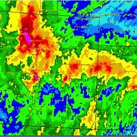
Colorado’s Extreme Weather Event Smashes Records
26 Sep 2013 - Colorado rainfall records going back to 1893 were shattered by September's intense and persistent rainstorm.
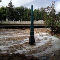
Boulder Creek CZO responds to record-breaking Colorado rainfall and flooding
13 Sep 2013 - Investigators and staff rush into action to collect samples and observe impacts
Explore Further
