Northeastern Puerto Rico and the Luquillo Mountains
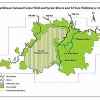
The Luquillo Critical Zone Observatory (LCZO) is located in Luquillo Mountains of northeastern Puerto Rico. This Includes El Yunque National Forest, Rio Mameyes and Rio Blanco watersheds, surrounding coastal plains and nearby urbanized areas such as the San Juan metro area, Luquillo and Fajardo.
1000-5000 mm Precip
Lithology
other sedimentary, other igneous, meta-igneous, other metamorphic
Soil Order
Inceptisol, Oxisol
Biome
rainforest
Areas within Northeastern Puerto Rico and the Luquillo Mountains
-
Setting & Research
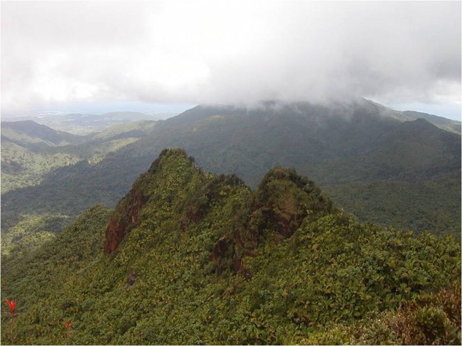
The Luquillo Critical Zone Observatory is located in the windward, Northeastern portion of Puerto Rico and in one of the wettest regions of the Caribbean. Over a distance of 10 to 20 km, this mountain range rises from sea level to an elevation of 1075 meters. The Luquillo Mountains are the headwaters to 9 rivers that flow through steep, bedrock and boulder-lined channels until they reach their coastal plain alluvial reaches. These rivers provide much of the water to the eastern portion of the San Jaun metro area, which in it's entirety contains roughly 2.5 million people as well as areas to the east including Fajardo, Cieba and Luquillo which contain roughly 80,000 people. Three principal rock types underlay the LM: volcaniclastic (VC), quartzdiorite (QD), and contact metamorphic hornfels (HF). Smaller out crops of basalt, mafic dikes, and alluvium also occur. Both types of bedrock were derived from a genetically related andesitic magma that was active in the lower Tertiary (Brocard this volume).
-
Overview Maps
Luquillo Mountains
_to_East_Peak_900_588_80auto.jpg)
Luquillo Mountains from direction of trade winds (76.7 degrees).
See full size (in new tab/window)
-
Data
Eastern Puerto Rico - Stream Water Chemistry, Stream Ecology - Data and R scripts (2009-2014)
1 components • Northeastern Puerto Rico and the Luquillo Mountains • Biogeochemistry, Water Chemistry • McDowell, William H.; McDowell, William G.; Potter, Jody; Ramirez, Alonso; Leon, Miguel C.El Verde - Soil Moisture - Soil Respiration, Oxygen and Water Content (2014-2016)
4 components • Northeastern Puerto Rico and the Luquillo Mountains • Biogeochemistry, Biology / Ecology, Soil Science / Pedology • Whendee SilverEl Verde, Icacos, Espiritu Santo, and Bisley - Stream Water Chemistry, Streamflow / Discharge, Air Temperature, Stream Water Temperatures (2014-2019)
8 components • Northeastern Puerto Rico and the Luquillo Mountains • Biology / Ecology, Hydrology, Water Chemistry • McDowell, William H.Luquillo Mountains - Meteorology, Air Temperature - Daily (2002-2009)
1 components • Northeastern Puerto Rico and the Luquillo Mountains • Climatology / Meteorology • Scatena, F.N.; IITFLuquillo Mountains - Soil Geochemistry - Phosphorus (2010)
6 components • Northeastern Puerto Rico and the Luquillo Mountains • Biogeochemistry • Porder, S.Luquillo Mountains - Soil Geochemistry - X-ray Florescence (2010)
2 components • Northeastern Puerto Rico and the Luquillo Mountains • Geochemistry / Mineralogy • Nawal, C.; Scatena, F.N.Luquillo Mountains - Soil Survey - acid phosphatase kinetic parameters (2012)
1 components • Northeastern Puerto Rico and the Luquillo Mountains • Biogeochemistry • Stone, M.M.; Plante, A.F.Luquillo Mountains - Geophysics, Ground Penetrating Radar (GPR) (2012-2015)
2 components • Northeastern Puerto Rico and the Luquillo Mountains • Geophysics • Comas, Xavier; Hynek, Scott; Wright, William; Brantley, Susan L.Luquillo Mountains - Soil Redox Potential, Soil Biogeochemistry - Fe speciation, redox (2016-2018)
1 components • Northeastern Puerto Rico and the Luquillo Mountains • Biogeochemistry, Soil Science / Pedology • Elizabeth K. Coward; Aaron Thompson; Alain F. PlanteLuquillo Mountains - Photographic Imagery, Meteorology - Cloud cover imagery (2014-2016)
1 components • Northeastern Puerto Rico and the Luquillo Mountains • Climatology / Meteorology • Bassiouni, Maoya; Scholl, Martha A.; Torres-Sanchez, Angel J.; Murphy, Sheila F.Luquillo Mountains, Puerto Rico - Precipitation, GIS/Map Data (2014)
1 components • Northeastern Puerto Rico and the Luquillo Mountains • Climatology / Meteorology, GIS / Remote Sensing • Murphy, S.F.; Stallard, R.F.; Scholl, M.A.; Gonzalez, Grizelle; Torres-Sanchez, AngelNational - Climate, Flux Tower, Streamflow / Discharge - CUAHSI WDC web services (1968-2015)
7 components • Boulder Creek Watershed, Christina River Basin, Jemez River Basin, Santa Catalina Mountains, El Verde Field Station, Northeastern Puerto Rico and the Luquillo Mountains, Rio Blanco, Rio Mameyes, Susquehanna Shale Hills Critical Zone Observatory, Providence Creek Headwater Catchments (1660 - 2115 m elevation), Wolverton Basin (2230 - 2700 m elevation), Other instrumented sites • Climatology / Meteorology, Hydrology, Soil Science / Pedology • Boulder Creek Critical Zone Observatory; Catalina-Jemez Critical Zone Observatory; Luquillo Critical Zone Observatory; Shale Hills Critical Zone Observatory; Southern Sierra Critical Zone Observatory; Christina River Basin Critical Zone ObservatoryNational - LiDAR, Land Cover, GIS/Map Data - OpenTopography (2010-2017)
18 components • Boulder Creek Watershed, Eel River Watershed, Jemez River Basin, Reynolds Creek Experimental Watershed, Susquehanna Shale Hills Critical Zone Observatory, Northeastern Puerto Rico and the Luquillo Mountains, Sangamon River Basin, Clear Creek Watershed, Calhoun Critical Zone Observatory, Providence Creek Headwater Catchments (1660 - 2115 m elevation) • Geomorphology, GIS / Remote Sensing, Hydrology, Biology / Ecology • National Center for Airborne Laser Mapping; Boulder Creek Critical Zone Observatory; Calhoun Critical Zone Observatory; University of Arizona; University of California Merced; Valles Caldera National Preserve; Bandelier National Monument; National Park Service; Jemez River Basin and Santa Catalina Mountains Critical Zone Observatory; Luquillo Critical Zone Observatory; Reynolds Creek CZO; Eel River CZO; Shale Hills CZONational - Soil Gas - CO2 and O2 (2014-2017)
2 components • Bigelow Site (High-Elevation), Jemez 2013 Burned ZOB, Jemez Unburned Site, Calhoun CZO Research Area 1, Garner Run - Sandstone Forested, Northeastern Puerto Rico and the Luquillo Mountains • Biogeochemistry, Climatology / Meteorology, Soil Science / Pedology, Biology / Ecology • Brecheisen, Zachary; Chorover, Jon; Kaye, Jason; Silver, Whendee; Abramson, Nate; Barron-Gafford, Greg; Condon, Katherine E.; Cook, Charles W.; Hill, Lillian; Losleben, Mark; Minor, Rebecca; O'Connell, Christine; Richter, Daniel deB.; Durcik, MatejNational - Streamflow / Discharge - USGS and USDA Data Resources (1985-2017)
22 components • Boulder Creek Watershed, Santa Catalina Mountains, Jemez River Basin, Reynolds Creek Experimental Watershed, Susquehanna Shale Hills Critical Zone Observatory, Northeastern Puerto Rico and the Luquillo Mountains, Clear Creek Watershed, Sangamon River Basin, Calhoun Critical Zone Observatory, Providence Creek Headwater Catchments (1660 - 2115 m elevation) • Hydrology • USGS National Water Information SystemNortheastern Puerto Rico - GIS/Map Data, LiDAR (2010-2011)
1 components • Northeastern Puerto Rico and the Luquillo Mountains • All Disciplines • Luquillo Critical Zone ObservatoryNortheastern Puerto Rico - GIS/Map Data - GIS web map and Datasets (1998-2019)
1 components • Northeastern Puerto Rico and the Luquillo Mountains • All Disciplines • Leon, M.Northeastern Puerto Rico - Soil Gas - Soil Chemistry and Greenhouse Gas Emissions (2011)
1 components • Northeastern Puerto Rico and the Luquillo Mountains • Biogeochemistry • G. McNicol; W. L. SilverNortheastern Puerto Rico - Stream Ecology, Vegetation - Luquillo LTER (1975-2018)
3 components • Northeastern Puerto Rico and the Luquillo Mountains • All Disciplines, Biology / Ecology • Luquillo Long Term Ecological Research (LTER)Northeastern Puerto Rico - Soil Microbes, Soil Geochemistry - Enzyme activity and microbial community structure (2011-2012)
1 components • Northeastern Puerto Rico and the Luquillo Mountains • Biogeochemistry • Stone, M.M., DeForest, J.L., Plante, A.F.Northeastern Puerto Rico - Soil Mineralogy - Mineral content of soils 0-20 cm XRD (2010-2011)
2 components • Northeastern Puerto Rico and the Luquillo Mountains • Geochemistry / Mineralogy • Zhuo WangNortheastern Puerto Rico - Soil Biogeochemistry - soil organic matter; Iron phase crystallinity (2016-2018)
1 components • Northeastern Puerto Rico and the Luquillo Mountains • Biogeochemistry • Steven J. Hall; Asmeret A. Berhe; Aaron ThompsonNortheastern Puerto Rico - Soil Biogeochemistry - landscape-scale soil biogeochemistry and enzymes (2012)
1 components • Northeastern Puerto Rico and the Luquillo Mountains • Biogeochemistry • Hall, Steven J.Northeastern Puerto Rico and the Luquillo Mountain - GIS/Map Data (2011-2016)
2 components • Northeastern Puerto Rico and the Luquillo Mountains • All Disciplines • Porder, Stephen; Johnson, Arthur H.; Xing, Hao Xing; Brocard, Gilles; Goldsmith, Steven; Pett-Ridge, Julie; Hall, Steven J.; Silver, Whendee L.; Treffkorn, JonathanNortheastern Puerto Rico and the Luquillo Mountain - Soil Survey (2011-2012)
11 components • Northeastern Puerto Rico and the Luquillo Mountains, Bisley • Biogeochemistry, Geochemistry / Mineralogy • Johnson, A.J.; Xing, HaoPrieta arm B and Gatos - Topographic Carbon Storage, Tree Growth & Physiology - Leaf litter collected over channel (2010-2016)
3 components • Northeastern Puerto Rico and the Luquillo Mountains • Biology / Ecology • Alonso RamirezPuerto Rico - GIS/Map Data - land use (2000-2016)
1 components • Northeastern Puerto Rico and the Luquillo Mountains • GIS / Remote Sensing • Gould, William, A.; Wadsworth, Frank, H.; Quinones, Maya.; Fain, Stephen J.; Alvarez-Berrios, Nora L.Puerto Rico - GIS/Map Data (1998)
1 components • Northeastern Puerto Rico and the Luquillo Mountains • GIS / Remote Sensing, Geophysics, Geochemistry / Mineralogy • Bawiec, W.J.; USGSPuerto Rico - GIS/Map Data (1998-2012)
2 components • Northeastern Puerto Rico and the Luquillo Mountains • GIS / Remote Sensing, Geophysics, Geochemistry / Mineralogy • Leon, M.C.Puerto Rico - GIS/Map Data - San Juan ULTRA Mapping Data (1936-2016)
1 components • Northeastern Puerto Rico and the Luquillo Mountains • All Disciplines • San Juan UltraPuerto Rico - Groundwater Chemistry, Groundwater Depth, Stream Water Chemistry, Streamflow / Discharge, Precipitation, Meteorology - USGS Caribbean Water Science Center (1969-2016)
6 components • Northeastern Puerto Rico and the Luquillo Mountains • All Disciplines • US Geological Survey Caribbean Water Science CenterPuerto Rico - Precipitation, Reservoir Height, Streamflow / Discharge - Schoolyard Data Jam (1990-2016)
6 components • Rio Mameyes, Northeastern Puerto Rico and the Luquillo Mountains • Hydrology, Soil Science / Pedology, Outreach / Education Research • USGS; USDA USFS; Whendee Silver; Miguel LeonPuerto Rico - Precipitation - NOAA NWS Precipitation Estimates (2003-2016)
2 components • Northeastern Puerto Rico and the Luquillo Mountains • Climatology / Meteorology • M. Bonnin; D. Martin; B. Lin; T. Parzybok; M. Yekta; D. RileyPuerto Rico - Stable Isotopes - Stable Isotope (δ18O and δ2H) Data (1994-2013)
8 components • Northeastern Puerto Rico and the Luquillo Mountains, Rio Icacos, East Peak, Rio Mameyes • Hydrology, Water Chemistry, Climatology / Meteorology • Martha A. Scholl; Angel Torres-Sanchez; Manuel Rosario-TorresPuerto Rico - Geomorphology - Stream channel geomorphology (2009-2012)
1 components • Northeastern Puerto Rico and the Luquillo Mountains • Geomorphology • Phillips, C.B.Puerto Rico- Coastal Zone - Digital Elevation Model (DEM), LiDAR - 2016 USACE NCMP Topobathy Lidar (2016)
1 components • Northeastern Puerto Rico and the Luquillo Mountains • GIS / Remote Sensing • U.S. Army Corps of Engineers (USACE); JALBTCX (Joint Airborne Lidar Bathymetry Technical Center of eXpertise); Department of Commerce (DOC); National Oceanic and Atmospheric Administration (NOAA); National Ocean Service (NOS); Office for Coastal Management (OCM)Shale Hills, Boulder, Luquillo, JRB-SCM, Calhoun - Soil Geochemistry (2001-2013)
1 components • Susquehanna Shale Hills Critical Zone Observatory, Bisley, Boulder Creek Watershed, Northeastern Puerto Rico and the Luquillo Mountains, Santa Catalina Mountains • Geochemistry / Mineralogy, Biogeochemistry • Niu, Xianzeng; Williams, Jennifer; Brantley, Susan L.; Miller, Doug; Bills, Brian -
Partner Organizations

-
Geology
- other sedimentary
- other igneous
- meta-igneous
- other metamorphic
Observatory Geology
Three principal rock types underlay the LM: volcaniclastic (VC), quartzdiorite
(QD), and contact metamorphic hornfels (HF). Smaller out crops of basalt, mafic dikes,
and alluvium also occur. Both types of bedrock were derived from a genetically related
andesitic magma that was active in the lower Tertiary (Brocard this volume). The VC
bedrock consists of thick layers of volcanic debris interbeded with shallow marine clays.
The Luquillo Quartz Diorites are part of a system of felsic batholiths that outcrop across
PR. Their emplacement was not accompanied by significant host rock folding but the
associated contact metamorphism did produce the erosion resistant hornfels (HF) that
currently forms the divide between the 2 watersheds and the highest peaks in the LM
In general, areas underlain by the GD have faster weathering rates, sandy
eutropeptic soils, and relatively deep subsurface flow paths (McDowell et al 1992, Brown
et al 1995, White et al 1998, Peters et al 2006). These areas also have a higher frequency
of landslides, well defined floodplains, and lower gradient, sandy bedded streams
(Ahmad, et al. 1993, Larsen et al 1998, Pike 2006). In contrast, areas underlain by VC
rocks weather to deep, clayey tropohumultic soils that have shallow subsurface flow
paths (Silver et al 1994, Schellekens 2004), steeper hillslopes, fewer and smaller
landslides, and relatively steep, boulder lined stream. Annual suspended sediment
discharge can be 5 to 16 times higher under the GD that comparable VC watersheds -
Topography
0 - 1075 m elevation
The Luquillo Critical Zone Observatory is located in the windward, Northeastern portion of Puerto Rico. Over a distance of 10 to 20 km, this mountain range rises from sea level to an elevation of 1075 meters. The Luquillo Mountains are the headwaters to 9 rivers that flow through steep, bedrock and boulder-lined channels until they reach their coastal plain alluvial reaches.
-
Climate
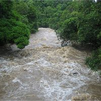
26 °C Mean Warmest Month 22.8 °C Mean Coldest Month 1000-5000 mm Mean Annual Precipitation The Luquillo Critical Zone Observatory is located in the windward, Northeastern
portion of Puerto Rico and in one of the wettest regions of the Caribbean. Over a
distance of 10 to 20 km, this mountain range rises from sea level to an elevation of 1075
meters. The Observatory has a subtropical, humid, maritime climate that is influenced by
both orographic and global-scale synoptic weather systems. Rainfall is relatively evenly
distributed throughout the year and increases from 1000 mm/yr in the lowlands to nearly
5000 mm/yr at the highest elevations. Rainfall events at mid-elevations are generally
small (median daily rainfall 3 mm/day) but numerous (267 rain days per year) and of
relatively low intensity (< 5mm/hr). Nevertheless, individual storms with greater than
125 mm/day occur annually, and daily rainfalls greater than 600 mm have been recorded.
The most common disturbance-generating weather systems that affect the Luquillo
Mountains are (1) cyclonic systems, (2) noncyclonic intertropical systems, (3)
extratropical frontal systems, and (4) large- scale, coupled ocean-atmospheric events
(e.g., North Atlantic Oscillation, El Niño-Southern Oscillation). Unlike some tropical
forests, the Luquillo Mountains do not commonly have disturbances associated with the
passage of the Inter-Tropical Convergence Zone (ITCZ) or monsoonal rains. -
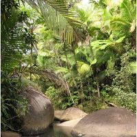
Ecosystems
- rainforest
See the Ecology and Forest Dynamics page for more information.
/luquillo/research/local-discipline/luquillo-ecology-and-forest-dynamics/
Explore Further
