Rio Mameyes
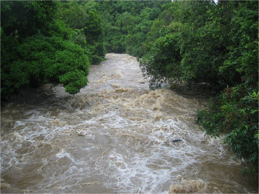
The Rio Mameyes flows in a northerly direction and has outstanding scenic, biological, recreation and historic values. The Rio Mameyes watershed covers 6.88 square miles within the forest, or 10.4% of the forest. Water quality is optimum within the study area of the upper segment, since the entire corridor is located in the Baño de Oro Natural Area and no development exist. Due to steep slopes, no significant flood plains occur. There are approximately 73 acres of riparian wetlands along the Rio Mameyes designated segments.
17.8191 km2 Area
Parent Field Area:
Northeastern Puerto Rico and the Luquillo Mountains ▲
Lithology
other igneous
Soil Order
Oxisol
Biome
rainforest
Land Use
forest land
Areas within Rio Mameyes
-
Setting & Research
"The area of the Río Mameyes, from the Forest boundary ½ mile west of the Road 988 bridge (Puente Roto) to its headwaters in the Baño de Oro Research National Area. Total length is 4.5 miles.
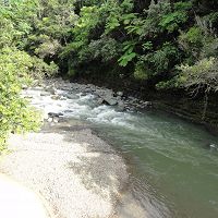
The portion of the Mameyes, from its headwaters to the confluence with the Río de la Mina, is remote and isolated. The stream course is a mass of jumbled boulders, and numerous small waterfalls and pools. Below the confluence with the La Mina, the Río Mameyes enters a narrow, very scenic, gorge of about one mile in length. Along the gorge run the Carrillo (#9) and La Coca (#8) trails.
The Mameyes Watershed covers 6.88 square miles within the Forest, or 10.4% of the Forest. The average discharge at Station 0655 is 58.6 cubic ft./sec. Water quality is optimum within the study area of the upper segment, since the entire corridor is located in the Baño de Oro natural area, and no development exists. Water quality is good within the study area of the lower segment, affected to some degree by recreation use on the Río de la Mina (a tributary of the Mameyes), and the heavy use near Puente Roto.
Source http://www.fs.fed.us/r8/caribbean/natural-resources/wild_scenic_rivers_wilderness.shtml"
-
Data
Bisley, Mameyes - Stream Water Chemistry (1986-2012)
2 components • Bisley, Rio Mameyes • Water Chemistry • Argerich, A.; Johnson, S.L.; Sebestyen, S.D.; Rhoades, C.C.; Greathouse, E.; Wohlgemuth, P.M.; Scatena, F.N.; McDowell, W.H.; Likens, G.E.; Knoepp, J.D.; Jones, J.B.; Ice, G.G.; Campbell, J.L.; Amatya, D.M.; Adams, M.B.Mameyes and Bisley - Sediment Transport - Grain size and shape analysis (2013)
1 components • Rio Mameyes, Bisley • Geomorphology • Litwin Miller, Kimberly; Szabo, Timea; Jerolmack, Douglas; Domokos, GaborMameyes Watershed - Sediment Transport (2010-2012)
1 components • Rio Mameyes • Geomorphology • Phillips, C.B.National - Climate, Flux Tower, Streamflow / Discharge - CUAHSI WDC web services (1968-2015)
7 components • Boulder Creek Watershed, Christina River Basin, Jemez River Basin, Santa Catalina Mountains, El Verde Field Station, Northeastern Puerto Rico and the Luquillo Mountains, Rio Blanco, Rio Mameyes, Susquehanna Shale Hills Critical Zone Observatory, Providence Creek Headwater Catchments (1660 - 2115 m elevation), Wolverton Basin (2230 - 2700 m elevation), Other instrumented sites • Climatology / Meteorology, Hydrology, Soil Science / Pedology • Boulder Creek Critical Zone Observatory; Catalina-Jemez Critical Zone Observatory; Luquillo Critical Zone Observatory; Shale Hills Critical Zone Observatory; Southern Sierra Critical Zone Observatory; Christina River Basin Critical Zone ObservatoryPuerto Rico - Precipitation, Reservoir Height, Streamflow / Discharge - Schoolyard Data Jam (1990-2016)
6 components • Rio Mameyes, Northeastern Puerto Rico and the Luquillo Mountains • Hydrology, Soil Science / Pedology, Outreach / Education Research • USGS; USDA USFS; Whendee Silver; Miguel LeonPuerto Rico - Stable Isotopes - Stable Isotope (δ18O and δ2H) Data (1994-2013)
8 components • Northeastern Puerto Rico and the Luquillo Mountains, Rio Icacos, East Peak, Rio Mameyes • Hydrology, Water Chemistry, Climatology / Meteorology • Martha A. Scholl; Angel Torres-Sanchez; Manuel Rosario-TorresRio Mameyes and Rio Icacos - Stream Suspended Sediment, Streamflow / Discharge, Precipitation - riverine particulate organic matter export (1991-2015)
8 components • Rio Mameyes, Rio Icacos • Biogeochemistry, Hydrology, Climatology / Meteorology • Clark, Kathryn E.; Stallard, Robert F.; Stallard, Martha A.; Plante, Alain F.; Plante, Sheila F.; Plante, Grizelle; McDowell, William H.Rio Mameyes and Rio Icacos - Stream Suspended Sediment, Streamflow / Discharge, Stream Water Chemistry (2015)
3 components • Rio Mameyes, Rio Icacos • Hydrology, Water Chemistry, Biogeochemistry, Geochemistry / Mineralogy • Clark, Kathryn E.; McDowell, William H.; Shanley, James; Perdrial, Nicolas; Scholl, Martha
-
Ecosystems
- rainforest
"The Río Mameyes provides habitat for the Puerto Rican Parrot and the Puerto Rican Boa, both endangered species. The endangered Broad-winged and Sharp-shinned Hawks, and the threatened Peregrine Falcon, are also known to occasionally use the area. No species of sensitive coquís are known to occur in the Río Mameyes, but the numerous waterfalls associated with this system could potentially support populations of the Web-footed Coquí. Suitable habitat also exists for the sensitive Red Fruit Bat.
No endangered plant species are known to occur along the Mameyes. Three sensitive plant species: Niño de Cota (Laplacea portoricensis), Saintedwood (Ternstroemia heptasepala), and Schwaneck’s Logwood (Xylosma schwaneckeanum), are known to occur in the area. The unique Pterocarpus (Pterocarpus officinalis) Forest occurs within the river corridor. Stands of this buttress-rooted tree are uncommon not only on the island but throughout the Caribbean.
The Mameyes River is the only river in the Island that runs un-interrupted from its origin to the sea. Therefore the Mameyes system enjoys the highest natural aquatic diversity and species richness of any Forest watershed; supporting all 5 species of native fish, all 9 species of freshwater shrimp, and its only freshwater crab. Because of its pristine and primitive condition it serves as a baseline for research comparison with all other rivers.
Source http://www.fs.fed.us/r8/caribbean/natural-resources/wild_scenic_rivers_wilderness.shtml"
Explore Further
