Dataset Listings
These dataset listings are out of date and have been archived.
See the updated listings on HydroShare.org >
Sangamon River Basin
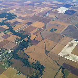
3,690 km2, 180-291 m elevation, 11 °C, 1000 mm/yr
The Sangamon River Basin includes a broad range of variations typical of the glaciated Midwest, which offer an opportunity to better understand the critical zone in this region. The basin is characterized by low-relief landscapes with poorly drained soils. The hydrological and biogeochemical cycles are strongly affected by freeze–thaw cycles and artificial drainage systems. The landscape is covered with patchy, thin loess (<1.5 m). This basin has a poorly integrated, natural drainage network with extensive areas of poorly drained soils. Weathering profiles are relatively thin and usually grade to unweathered fine-grained glacial till within 5 m of the land surface. Soil patterns generally reflect glacial depositional patterns, except where modified by stream processes in valleys.
National - Streamflow / Discharge - USGS and USDA Data Resources (1985-2017)
22 components •
Boulder Creek Watershed, Santa Catalina Mountains, Jemez River Basin, Reynolds Creek Experimental Watershed, Susquehanna Shale Hills Critical Zone Observatory, Northeastern Puerto Rico and the Luquillo Mountains, Clear Creek Watershed, Sangamon River Basin, Calhoun Critical Zone Observatory, Providence Creek Headwater Catchments (1660 - 2115 m elevation) •
Hydrology •
USGS National Water Information System
Clear Creek Watershed
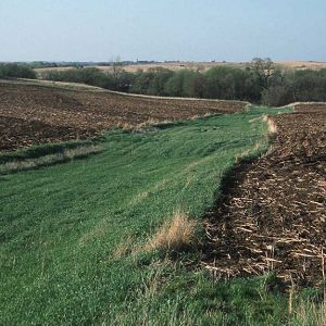
270 km2, 197-248 m elevation, 9 °C, 889 mm/yr
The Clear Creek, Iowa, watershed covers approximately 270 km2 in East Central Iowa and joins the Iowa River in Coralville, Iowa. Clear Creek is representative of most U.S. Midwestern watersheds with regards to land use (predominantly agricultural), soil type/order (Alfisols and Mollisols), and climate (humid-continental). The combination of extensive agricultural activities, increased urbanization, highly erodible soils, and a humid climate on the steep slopes within the watershed have influenced the erosion processes in the watershed.
National - Streamflow / Discharge - USGS and USDA Data Resources (1985-2017)
22 components •
Boulder Creek Watershed, Santa Catalina Mountains, Jemez River Basin, Reynolds Creek Experimental Watershed, Susquehanna Shale Hills Critical Zone Observatory, Northeastern Puerto Rico and the Luquillo Mountains, Clear Creek Watershed, Sangamon River Basin, Calhoun Critical Zone Observatory, Providence Creek Headwater Catchments (1660 - 2115 m elevation) •
Hydrology •
USGS National Water Information System
Minnesota River Basin
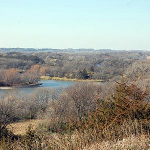
44,000 km2, 210-294 m elevation, 5 °C, 747 mm/yr
The Minnesota River flows more than 335 miles from its source near the Minnesota-South Dakota border to its confluence with the Mississippi River at Minneapolis/St. Paul. It winds through diverse landscapes and drains nearly 20 percent of Minnesota (16,770 square miles total, 14,840 in Minnesota). Agriculture, primarily corn and soybean production, accounts for the majority of the basin’s land use. As the river enters the Twin Cities Metropolitan area, the basin is characterized by densely populated urban landscapes. The Minnesota River has been cited as one of the most polluted rivers in the state and the nation. In 2008, it was listed on American Rivers top 10 most endangered rivers in the United States. It is the focus of a major restoration effort by local, state, and federal agencies, as well as citizen and nonprofit groups.
-
Data Use Policy
DRAFT v.0.4.0
1. Use our data freely. All CZO Data Products* except those labelled Private** are released to the public and may be freely copied, distributed, edited, remixed, and built upon under the condition that you give acknowledgement as described below. Non-CZO data products — like those produced by USGS or NOAA — have their own use policies, which should be followed.
2. Give proper citation and acknowledgement. Publications, models and data products that make use of these datasets must include proper citation and acknowledgement. Most importantly, provide a citation in a similar way as a journal article (i.e. author, title, year of publication, name of CZO “publisher”, edition or version, and URL or DOI access information. See http://www.datacite.org/whycitedata). Also include at least a brief acknowledgement such as: “Data were provided by the NSF-supported Southern Sierra Critical Zone Observatory” (replace with the appropriate observatory name).
3. Let us know how you will use the data. The dataset creators would appreciate hearing of any plans to use the dataset. Consider consultation or collaboration with dataset creators.
*CZO Data Products. Defined as a data collected with any monetary or logistical support from a CZO.
**Private. Most private data will be released to the public within 1-2 years, with some exceptionally challenging datasets up to 4 years. To inquire about potential earlier use, please contact us.
Explore Further
