New study suggests bedrock weathering based on topography
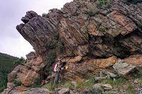
A new study, Geophysical imaging reveals topographic stress control of bedrock weathering (St. Clair et al., 2015), was published in Science. The study suggests tectonic stresses interact with topography to influence bedrock weathering. Investigators took geophysical surveys to capture bedrock fracturing at three sites; Boulder Creek and Calhoun CZOs, and Pond Branch, Maryland. These measurements combined with a three-dimensional stress model show bedrock erostion rates mirror changes in topography. This research was a collabrative effort between investgators from University of Wyoming, MIT, University of Hawaii; and Boulder Creek, Calhoun and Christina CZOs.
A Perspective piece on this study was also published in Science by Robert Anderson (Boulder Creek CZO), Pinched topography initiates the critical zone.
The video below by Melanie Gonick of MIT News, describes this research and how it pertains the thickness of bedrock within the Critical Zone. The source of the video and the accompanying article from MIT News can be found at the following link: http://news.mit.edu/2015/bedrock-weathering-based-on-topography-1029.
News Source:
READ MORE from MIT News >>
News Category:
RESEARCH |
PUBLICATIONS
People Involved
CZO
-
Boulder, Calhoun, Eel, Reynolds, Sierra, COLLABORATOR
-
Sierra, INVESTIGATOR
-
Christina, INVESTIGATOR
-
Boulder, Shale Hills, INVESTIGATOR
-
Calhoun, INVESTIGATOR
-
Boulder, INVESTIGATOR
Publications
2015
Geophysical imaging reveals topographic stress control of bedrock weathering. St. Clair, J., S. Moon, W. S. Holbrook, J. T. Perron, C. S. Riebe, S. J. Martel, B. Carr, C. Harman, K. Singha, D. deB. Richter (2015): Science 350 (6260): 534-538
Discipline Tags and CZOs
Geophysics
Modeling / Computational Science
National
Boulder
Calhoun
Christina
Explore Further


