LiDAR
Share LiDAR via OpenTopography
SUMMARY: The Critical Zone Observatories program partners with OpenTopography for LiDAR data. OpenTopography is an NSF-funded project for the specific purpose of hosting a centralized LiDAR repository. OpenTopography allows users to access and process LiDAR point cloud data on the fly for an area of interest. The goal of the system is to provide a web-based toolset that can democratize access to massive and potentially computationally challenging LiDAR topography datasets.
CZOData Team Contacts: Tom Whitenack and Ilya Zaslavsky
Questions? Email the CZOData Project team
Data Policies & Guidelines > Data Sharing Guidelines > LiDAR
Benefits and Outcomes
The airborne altimetric LiDAR (Light Detection and Ranging) technology has important advantages over traditional methods of topographic data collection. The key advantage is higher vertical and horizontal accuracy: between 2-15 cm in elevation, and 30-50 cm horizontally. Another important benefit is high level of automation in the development of digital elevation models for large areas, as well as canopy penetration and independence of data collection of weather conditions. As a result, LiDAR data are being widely used in research applications, as well as in multiple land management and engineering projects.
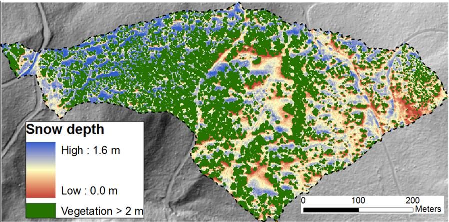
Analysis of LiDAR data collected during periods of snow on (March 2010) and snow off (July 2010) enables determination of relations between vegetation structure, aspect and snow depth in the Jemez River Basin mixed conifer ZOB (Harpold et al.).
CZOData partners with OpenTopography, an NSF-supported data facility at SDSC, which provides community access to high-resolution topographic data in multiple formats and to related data processing tools. Several CZO high-resolution LiDAR datasets are already available through OpenTopography. These include Shale Hills CZO Leaf Off and Leaf On surveys; Liquillo CZO LiDAR Survey for the Rio Marneyes and Rio Bianco Watersheds; Christina River Basin LiDAR survey for analysis of vegetation characteristics, stream channels and floodplain geomorphology; Boulder Creek Snow-Off LiDAR survey; Southern Sierra Snow-Off LiDAR survey, etc. CZOData search portal (search.criticalzone.org) is federated with the OpenTopography catalog: as a result, CZO-related LiDAR data can be found by searching the common CZO catalog of information sources.
Instructions
To start, go to http://www.opentopography.org and create an account. Once your account is created, login and go to the data/contribute page. When you click “contribute data” you will be prompted with a form to fill out. Here’s a list of the information you’ll need:
Required fields include:
A Dataset name
Descriptive name for dataset. Useful information in dataset name may include state or geographic area surveyed, when the data were collected, and/or who funded or partnered in the project.
One or two short paragraphs explaining the purpose of the data collection, dataset parameters and any acknowledgements for collection, funding and involved institutions
The URL where the dataset can be downloaded, or where information about the dataset can be found. Either a "Download URL" or "Project URL" is required
Additional information
- Look through the public forum for the CZOData IMC (Information Management Committee)
- Ask a public email question to the CZOData IMC forum (if a member).
- Ask a private email question to the CZOData Project team.
Analysis of LiDAR data collected during periods of snow on (March 2010) and snow off (July 2010) enables determination of relations between vegetation structure, aspect and snow depth in the Jemez River Basin mixed conifer ZOB (Harpold et al.).
Explore Further
