ABOUT


Do not fill out this information.
On this particular page, the Initial Text and Image fields for this template are not used (inactive). A Carousel Slideshow is displayed instead.
To edit the Carousel Slideshow, Choose Edit Existing > Carousel Slides. Then navigate to your CZO's entry entitled "About"
The National CZO Program is a community resource.
The NSF-supported Program serves the international scientific community through research, infrastructure, data, and models.
We focus on how components of the Critical Zone interact, shape Earth's surface, and support life. If you are interested in conducting research at one or more of the CZOs, please check our Opportunities page.
The Critical Zone Observatory National Office (CZO-NO) provides logistical support and leadership for a variety of network-wide activities.
RESEARCH
Supported by NSF - National Science Foundation, Geoscience Directorate, Earth Science Division.
Interdisciplinary - Hydrology, geology, soil science, biology, ecology, geochemistry, and more.
Developing predictive ability for how the Critical Zone will respond to projected climate and land-use changes.
INFRASTRUCTURE
Nine US observatories - From Puerto Rico to California. (See detailed PDF table of site characteristics).
Community of researchers collaboratively working at the same field sites.
Existing & new resources - Sensor and communication networks, eddy towers, boreholes, gauges and much more (some previously constructed by LTER, Forest Service, et al.)
DATA
Diverse datasets across disciplines and spatial and temporal scales.
Large data volumes from in situ sensors, field instruments, remote sensing, and more.
Integrating data across observatories and prior programs for discovery and synthesis.
MODELS
Coupled systems models that interconnect complex physical, chemical, and biological processes.
Watershed-scale simulations of fluxes of energy, water, carbon, sediments, and other materials.
Multi-scale & multi-process models that include landscapes and ecosystems.
Intro Videos
Explore the Critical Zone
View a 6.5 min video created by WSKG in collaboration with the CZO National Office:
Introduction
Note: This video was created years ago, before the CZO Program expanded from 6 to 9 observatories.
Produced by Shipherd Reed (University of Arizona), this video features interviews with researchers from the Jemez-Catalina CZO. See transcript.
Brief History
Early in 2007 the US National Science Foundation created the new Critical Zone Observatory (CZO) program and awarded funds to establish three initial observatories: Southern Sierra (California), Boulder Creek (Colorado) and Susquehanna Shale Hills (Pennsylvania). During 2009, an additional three CZOs were established: Jemez River Basin - Santa Catalina Mountains (Arizona/New Mexico), Christina River Basin (Delaware/Pennsylvania) and Luquillo Mountains (Puerto Rico). During 2013, the Calhoun Forest (S. Carolina), Intensively Managed Landscape (Minnesota, Illinois, Iowa), Reynolds Creek (Idaho), and Eel River (northern California) CZOs were added to the network. The Christina CZO was subsequently deactivated. Research and infrastructure at the nine active observatories is supported by the NSF Geoscience Directorate, Earth Science Division.
People
When all nine observatories are totaled together, there are currently about 250 people involved, of which approximately 70 are graduate students. The 250 person total includes PIs, collaborators and post docs; it does not include the numerous undergraduates who help during both the summer and the school year.
Print Materials
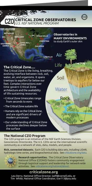
US NSF CZO Program Brochure 2014. See PDF version (5 MB)
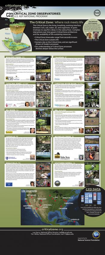
US NSF CZO Program Poster 2014. See PDF (3 MB, low resolution version)
Interested in learning more?
Images from all CZOs.
US NSF CZO Program Brochure 2014. See PDF version (5 MB)
US NSF CZO Program Poster 2014. See PDF (3 MB, low resolution version)
Associated Files
US NSF CZO Program Brochure 2014
(5 MB pdf)
Tri-fold brochure
US NSF CZO Program Poster 2014
(3 MB pdf)
Shown at AGU and elsewhere
Explore Further


