Hydrology Research Group
The Luquillo Mountains are the headwaters to 9 rivers and have a central igneous core that is surrounded by an apron of sedimentary rocks. All of the major rivers have continuous stream gages and many have long-term records of sediment and water chemistry. These rivers are hydrologically similar to many tropical montane streams and flow through steep, bedrock and boulder-lined channels until they reach their coastal plain alluvial reaches. High stream flows are common and tenfold increases in discharge have been recorded within an hour....
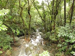
Image: Rio de la Mina south of La Coca Falls.
This group is tagged with:
-
The frequency of daily discharges is highly skewed as peak discharges are several hundred times average daily discharge. Short term, flash floods occur at least once a month and the annual peak discharge can occur in any month of the year but are most common in the late summer and fall. The largest floods are often, but not always associated with hurricanes. Water temperature in headwater streams is relatively consistent throughout the year and ranges between 18 and 24 °C. The average pH of stream water is 7.2. Stream discharge is highly variable and high flows can occur at any time of the year. Significant relationships exist between elevation and mean annual rainfall and runoff. Of the average annual rainfall input, 65% (2526 mm/yr) is converted to runoff. The remaining 35% (1338 mm/yr) is lost from the system by evapotranspiration and other abstractions. In comparison to other tropical forests, the Luquillo Mountains as a whole has more evapotranspiration than many tropical montane forests but less than many lowland tropical forests
The focal hydrologic questions being addressed by the Luquillo Critical Zone Observatory concern how hydrologic processes vary with bedrock lithology. Specifically, how rainfall-runoff relationships, storm water generation, and the transport of water and material fluxes varies with different bedrocks. Research facilities include instrumented watersheds and nested stream gages, and long-term measurements of rainfall and streamflow.LCZO Stream data is available for Bisley is available here.
Ongoing LCZO Hydrology research descriptions can be found here.
-
Contacts
-
Luquillo, INVESTIGATOR
5 People
Cross-CZO INVESTIGATOR, COLLABORATOR
.(JavaScript must be enabled to view this email address)
Georgia Tech
hydrology, geomorphology
Cross-CZO INVESTIGATOR, COLLABORATOR
.(JavaScript must be enabled to view this email address)
Near-surface geophysics
INVESTIGATOR, Lead-PI
.(JavaScript must be enabled to view this email address)
biogeochemistry, Hydrology
INVESTIGATOR
.(JavaScript must be enabled to view this email address)
Mercury and Carbon Biogeochemistry
Alumni-Former
INVESTIGATOR, PostDoc
.(JavaScript must be enabled to view this email address)
Ecohydrology
.(JavaScript must be enabled to view this email address)
Field Technician, Biogeochemistry
Cross-CZO GRAD STUDENT
.(JavaScript must be enabled to view this email address)
Hydropedology
-
-
Featured Publications
2004
Stormflow generation in a small rain-forest catchment in the Luquillo Experimental Forest, Puerto Rico. Schellekens, J., Scatena, F.N., Bruijinzeel L.A., Van Dijk, A.I.J.M., Groen, M.M.A., Hoogezand, R.J.P. (2004): Hydrological Processes
1999
Modeling rainfall interception by a lowland tropical rain forest in northeastern Puerto Rico. Schellekens, J., Scatena, F.N., Bruijinzeel L.A. (1999): Journal of Hydrology
2002
Prediction of Master Recession Curves and Baseflow Recessions in the Luquillo Mountains of Puerto Rico. Rivera-Ramirez, H.D., Warner, G.S., Scatena, F.N. (2002): Journal of the American Water Resources Association
Explore Further


