Deep fractures in the Luquillo critical zone
The interfaces where intact bedrock weathers to disaggregated material, such as saprolite and soil, are often hidden deep within the critical zone and are thus difficult to access. However, weathering of primary minerals along bedrock fractures located in the groundwater or deep vadose zones may supply significant weathering products to streams and oceans.
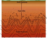
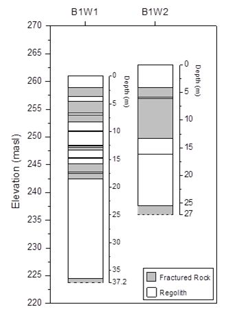
We investigated the deep critical zone in the VC and QD watersheds at the LCZO from boreholes drilled to 27-37 m depth. Continuous core samples revealed repeated zones of highly fractured rock, interpreted as subsurface corestones, embedded within layers of regolith. Some corestones are massive and others are highly fractured. Subsurface corestones are larger and less fractured in the borehole drilled under a ridge, compared to the borehole drilled near a stream channel. As corestone size is thought to be a function of fracture spacing, the location of the valleys and ridges in the watershed may be controlled by the fracture spacing of the underlying bedrock.
Drilling terminated in rock, thought to be bedrock based on our model that hypothesized a thickness for the corestone-regolith zone. The VC profiles indicate that weathering proceeds 10’s of meters below the elevation of the stream channel; thus weathering depth is not controlled by the Bisley stream base level. Furthermore, weathering rinds on fracture surfaces at depth indicate that water and oxygen are transported below the elevation of the stream channel; thus not all of the water in the watershed is discharged to the stream.
Figure 4. Diagram of boreholes drilled in the Bisley 1 (VC) watershed (Buss et al., 2013). All rock recovered was highly fractured with fractures spaced at mm to cm. Dashed lines at bottom of the cores indicate the deepest extent of drilling (inferred to be relatively un-weathered bedrock).
Buss H.L., Brantley S.L., Scatena F.N., Bazilievskaya E.A., Blum A., Schulz M., Jimenez R., White A.F., Rother G., Cole D. (2013) Probing the deep critical zone beneath the Luquillo Experimental Forest, Puerto Rico. Earth Surface Processes and Landforms. In Press. DOI: 10.1002/esp.3409
Fletcher and Brantley (2010) Reduction of bedrock blocks as corestones in the weathering profile: observations and model. Amer. J. Sci 310, 131-164.
Figure 4. Diagram of boreholes drilled in the Bisley 1 (VC) watershed (Buss et al., 2013). All rock recovered was highly fractured with fractures spaced at mm to cm. Dashed lines at bottom of the cores indicate the deepest extent of drilling (inferred to be relatively un-weathered bedrock).
News Category:
RESEARCH
People Involved
CZO
-
Luquillo, INVESTIGATOR
-
National, Eel, Luquillo, Shale Hills, INVESTIGATOR, COLLABORATOR
-
Luquillo, INVESTIGATOR
Explore Further


