St. Clair et al., 2015
Geophysical imaging reveals topographic stress control of bedrock weathering
St. Clair, J., S. Moon, W. S. Holbrook, J. T. Perron, C. S. Riebe, S. J. Martel, B. Carr, C. Harman, K. Singha, D. deB. Richter (2015)
Science 350 (6260): 534-538 Cross-CZO National
-

Boulder, Calhoun, COLLABORATOR
-

Boulder, Calhoun, Eel, Reynolds, Sierra, COLLABORATOR
-

Sierra, INVESTIGATOR
-

Christina, INVESTIGATOR
-

Boulder, Shale Hills, INVESTIGATOR
-

Calhoun, INVESTIGATOR
Abstract
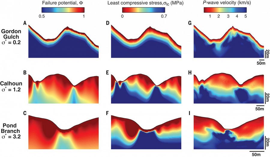
Comparisons of topographic stress and seismic velocity. Modeled failure potential (A to C), modeled magnitude of the least compressive stress (D to F), and measured P-wave velocity (G to I) for Gordon Gulch [(A), (D), and (G)], Calhoun [(B), (E), and (H)], and Pond Branch [(C), (F), and (I)]. Transect locations are marked in white in Fig. 2. The topographic surface was smoothed for stress calculations. Vertical exaggerations are 3.6× at Gordon Gulch, 3.7× at Calhoun, and 2.3× at Pond Branch.
Bedrock fracture systems facilitate weathering, allowing fresh mineral surfaces to interact with corrosive waters and biota from Earth’s surface, while simultaneously promoting drainage of chemically equilibrated fluids. We show that topographic perturbations to regional stress fields explain bedrock fracture distributions, as revealed by seismic velocity and electrical resistivity surveys from three landscapes. The base of the fracture-rich zone mirrors surface topography where the ratio of horizontal compressive tectonic stresses to near-surface gravitational stresses is relatively large, and it parallels the surface topography where the ratio is relatively small. Three-dimensional stress calculations predict these results, suggesting that tectonic stresses interact with topography to influence bedrock disaggregation, groundwater flow, chemical weathering, and the depth of the “critical zone” in which many biogeochemical processes occur.
Citation
St. Clair, J., S. Moon, W. S. Holbrook, J. T. Perron, C. S. Riebe, S. J. Martel, B. Carr, C. Harman, K. Singha, D. deB. Richter (2015): Geophysical imaging reveals topographic stress control of bedrock weathering. Science 350 (6260): 534-538. DOI: 10.1126/science.aab2210
 This Paper/Book acknowledges NSF CZO grant support.
Explore Further
