How does bedrock influence Critical Zone depth?
Justin Richardson in Adventures in the Critical Zone

Sep 06, 2016
Many of us are content with considering the cement and asphalt that blanket our sidewalks and roadways as solid earth, our terra firma. However, the depth to actual solid, unweathered bedrock can range within a few feet to hundreds of feet. The unconsolidated material (commonly referred to as regolith) and heavily weathered bedrock (also called saprolite) is physically and chemically different from unaltered bedrock. This might seem trivial in day to day life, but solid bedrock is very important to those who live in areas prone to sinkholes, landslides, and earthquake liquefaction. Unfortunately, the depth to bedrock is a complicated question and has many geological ramifications beyond a sudden sinkhole gobbling your car.
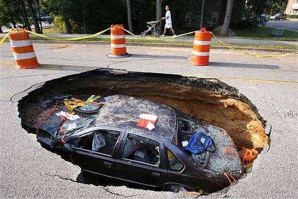
Figure 1. An automobile fell into a sinkhole in Gwinnett County, Georgia. Photo by Vino Wong.
Unweathered bedrock is largely considered the lower boundary of the Critical Zone (Riebe et al., 2016) and the depth to this boundary has significant regional and global implications. The depth of the Critical Zone affects how much water is stored. With increasing drought conditions across the U.S., water shortages are a growing concern not just for growing urban metropolitan areas in semi-arid southwestern states but also direly stretched groundwater resources in northeastern States. In addition, the depth of the Critical Zone is also essential for estimating the amount of carbon that is stored. So that brings us to our question, how does bedrock control the depth of the Critical Zone?
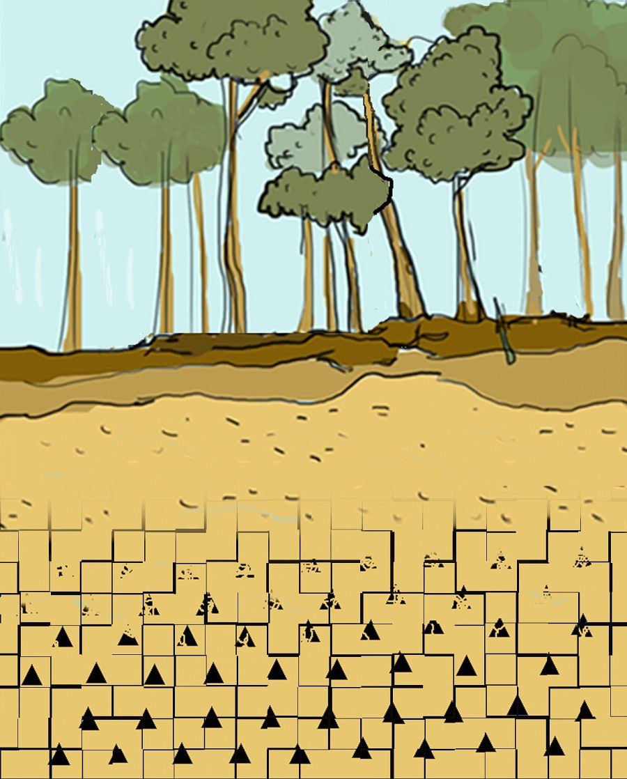
Figure 2. A cross-section of the Critical Zone, from the top of the vegetation down to the unweathered bedrock is shown.
Not all types of bedrock are equal when it comes to weathering. Dissolved oxygen and acids in water break down exposed mineral grains, causing the minerals to slowly disintegrate or change to less physically stable forms (commonly referred to as chemical weathering). Depending on the mineral composition, some rocks are more or less resistant to weathering than others (Riebe et al., 2016). Generally igneous rocks (like granite) are composed of minerals resistant to weathering (like quartz). Sedimentary rocks (like shale) are less resistant to weathering because exposure to water dissolves minerals holding them together (like carbonates). Holding all other variables equal, rocks resistant to weathering frequently have a shallower Critical Zone than rocks prone to weathering simply due to the differences in weathering rates.
The Critical Zone in colder areas can be controlled by how bedrock and water interacts with temperature. Riebe et al., (2016) have noted that the depth at which temperature affects the bedrock may be an alternative way to determine the depth of the Critical Zone. Their reasoning is that temperature can control how materials in the Critical Zone behave. For example, when the temperature begins to drop, water freezing can affect bedrock. When water freezes, it expands in volume, acting as atomic scale wedges that damages and fractures the rock. This cold climate process is commonly referred to as frost-cracking, and it leads to cracks and fractures in the bedrock (Graham et al., 2010; Anderson et al., 2013). Cracks and fractures accelerate bedrock weathering, creating a deeper Critical Zone.
In addition to mineralogy and climate, regional tectonic stresses (such as mountain building) and local tectonic stresses (ridge and valley formation) can create the fractures in bedrock. These cracks allow for water to seep deeper into the bedrock, accelerating the rate of weathering of the rock. The stresses on the bedrock are driven b the shape of the landscape. St. Clair et al (2015) studied the effect of bedrock on depth of the Critical Zone at the Calhoun, Boulder Creek, and Christina River Basin CZOs. The researchers observed that depth of Critical Zone was deeper up on slopes and shallower at the base of slopes, using seismic refraction (acoustic waves to detect bedrock) and electrical resistivity imaging (the movement of electric signals to measure the depth of water to detect bedrock). Most surprisingly, St. Clair et al (2015) noted that fractures were driven by topography because of tectonic stresses from the landforms themselves! This means the depth of the Critical Zone is dependent on the shape of the landscape, where differences in stresses creates fractures in the bedrock.
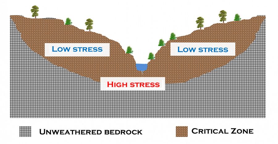
Figure 3. Based upon St. Clair et al 2015, high tectonic stress areas have a deeper Critical Zone while low tectonic stress areas have a shallow Critical Zone.
Linking the depth and shape of the Critical Zone to geophysical processes, such as tectonics and strain due to gravity is an up and coming area of Critical Zone science with much more to work to be done (Riebe et al., 2016). Understanding how Critical Zone depth is caused by weathering at the surface and bedrock processes is a growing research topic. St. Clair et al., (2014) have identified landscape processes very important for Critical Zone depth occurs in the bedrock itself. Others such as Brantley and Lebedeva (2011) have found that Critical Zone depth is driven by chemical weathering of bedrock from the surface down. Although each process may be dominant in certain locations depending on additional factors like climate, the depth of the Critical Zone is certainly a mix between the geochemistry and geophysics.
"It will be important to explicitly account for the physical and chemical role of lithology, which is challenging because subtle differences can have enormous effects on material properties" - W. Jesse Hahm, PhD student at Eel River CZO.
Future studies and models will need to combine geochemistry and geophysics to understand how they create the Critical Zone, together. Riebe et al., (2016) have identified four testable questions that will illuminate our knowledge on what controls Critical Zone depth. Each hypothesis seeks to link the chemical and physical changes that occur to bedrock. One of the project leaders, graduate student Jesse Hahm at Eel River CZO, describes these exciting research questions as “It will be important to explicitly account for the physical and chemical role of lithology, which is challenging because subtle differences can have enormous effects on material properties”. Thus, researchers have much to learn before we can definitively say what controls the depth of the Critical Zone.
Have any questions swirling in your noodle about the rock, soil, water, fauna, or flora of the Critical Zone? Send them our way at Askcriticalzone@gmail.com.
Science on!
Justin Richardson
Critical Zone Observatory Postdoctoral Fellow
References:
Anderson, R.S., Anderson, S.P., Tucker G.E., 2013. Rock damage and regolith transport by frost: an example of climate modulation of the geomorphology of the critical zone. Earth Surf. Process. Landforms 38:299–316.
DOI: 10.1002/esp.3330
Brantley, S.L. and Lebedeva, M., 2011. Learning to read the chemistry of regolith to understand the critical zone. Annual Review of Earth and Planetary Sciences: 39: 387-416
DOI: 10.1146/annurev-earth-040809-152321
Buss, H.L., Sak, P.B., Webb, S.M. and Brantley, S.L., 2008. Weathering of the Rio Blanco quartz diorite, Luquillo Mountains, Puerto Rico: Coupling oxidation, dissolution, and fracturing. Geochimica et Cosmochimica Acta, 72:4488-4507.
DOI: 10.1016/j.gca.2008.06.020
Graham RC, Rossi AM, Hubbert KR. 2010. Rock to regolith conversion: producing hospitable substrates for terrestrial ecosystems. GSA Today 20(2): 4–9.
DOI. 10.1130/GSAT57A.1
Riebe C.S., Hahm W.J., Brantley S.L., 2016. Controls on deep critical zone architecture: A historical review and four testable hypotheses. Earth Surface Processes and Landforms.
DOI: 10.1002/esp.4052
Rempe, D.M. and Dietrich, W.E., 2014. A bottom-up control on fresh-bedrock topography under landscapes. Proceedings of the National Academy of Sciences, 111:6576-6581.
DOI: 10.1073/pnas.1404763111
St. Clair, J.S., Moon, S., Holbrook, W.S., Perron, J.T., Riebe, C.S., Martel, S.J., Carr, B., Harman, C. and Singha, K., 2015. Geophysical imaging reveals topographic stress control of bedrock weathering. Science, 350(6260), pp.534-538.
DOI: 10.1126/science.aab2210
Figure 1. An automobile fell into a sinkhole in Gwinnett County, Georgia. Photo by Vino Wong.
Figure 2. A cross-section of the Critical Zone, from the top of the vegetation down to the unweathered bedrock is shown.
Figure 3. Based upon St. Clair et al 2015, high tectonic stress areas have a deeper Critical Zone while low tectonic stress areas have a shallow Critical Zone.

Justin B. Richardson
CZO INVESTIGATOR, STAFF. National Office outreach officer, Former CZO Post-Doctoral Fellow. Specialty: Soil biogeochemistry of plant-essential and toxic metals.
Geomorphology Soil Science / Pedology Geochemistry / Mineralogy
COMMENT ON "Adventures in the Critical Zone"
All comments are moderated. If you want to comment without logging in, select either the "Start/Join the discussion" box or a "Reply" link, then "Name", and finally, "I'd rather post as a guest" checkbox.
ABOUT THIS BLOG

ABOUT THIS BLOG
Justin Richardson and his guests answer questions about the Critical Zone, synthesize CZ research, and meet folks working at the CZ observatories
General Disclaimer: Any opinions, findings, conclusions or recommendations presented in the above blog post are only those of the blog author and do not necessarily reflect the views of the U.S. CZO National Program or the National Science Foundation. For official information about NSF, visit www.nsf.gov.
Explore Further
