Santa Catalina Mountains
The Santa Catalina Mountains (Catalina) are located northeast of Tucson in southern Arizona. This location includes three sites: one in the Sonoran desert on the mountain foothill; the second in the mid elevation and the third - high elevation in the Marshall Gulch Creek catchment and Bigelow site which includes zero order basin (ZOB) and flux tower.
1022 - 2780 m Elev
10-18 °C Temp
420-940 mm Precip
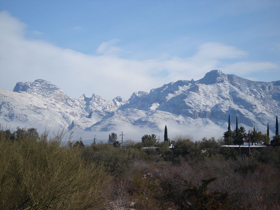
Santa Catalina Mountains in winter.
Areas within Santa Catalina Mountains
-
Setting & Research
The Santa Catalina Mountains are a metamorphic core complex typical of the Basin and Range Province of North America, and he bedrock is predominantly granite, schist and gneiss, with steep and rugged terrain covered by thin soils. Elevation ranges from 805 m at the mountain front at Sabino Canyon to 2800 m at Mount Lemmon, the tallest peak in the range. The east and west branches of upper Sabino Creek, the principal drainage on the south side of the Santa Catalinas, separate a distinct forerange from the bulk of the mountains to the north. Sabino Creek is the main ephemeral stream in the watershed, flowing an average of 294 days per year with a mean flow of 0.41 m3s-1. Many smaller canyons drain the forerange from north to south. Most of the mountains are managed as part of the Coronado National Forest, the southern border of which follows the sharply defined mountain front and forms an abrupt transition between the Pusch Ridge Wilderness and metropolitan Tucson.
-
Overview Maps
Map Overlays
-
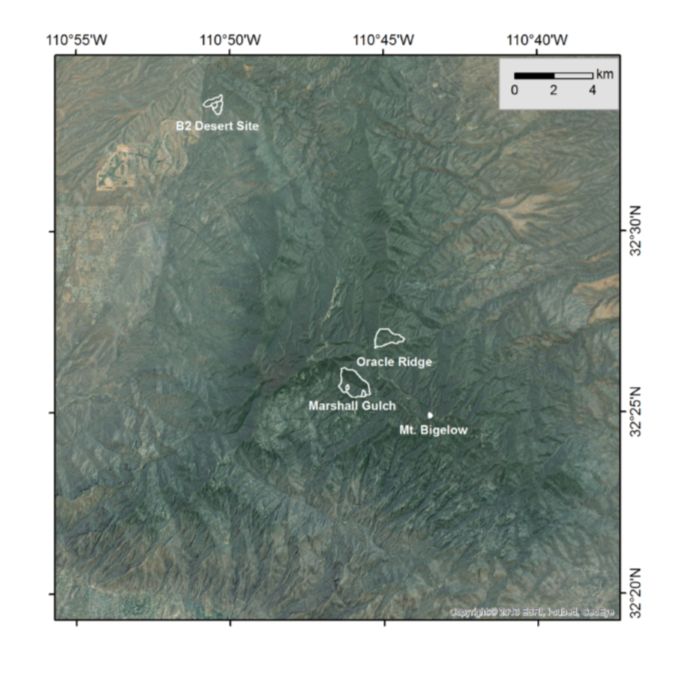
Santa Catalina Mountains Satellite Map
-
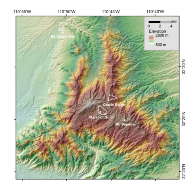
Santa Catalina Mountains Elevation Map
-
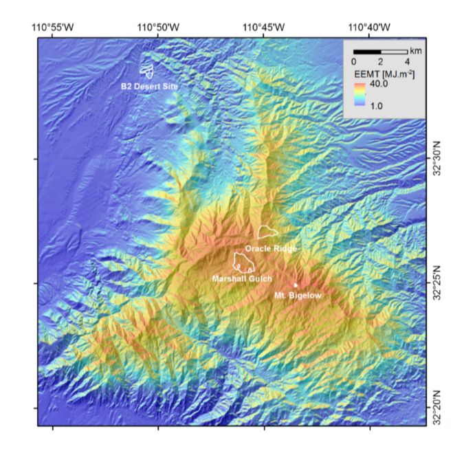
Santa Catalina Mountains EEMT Map
-
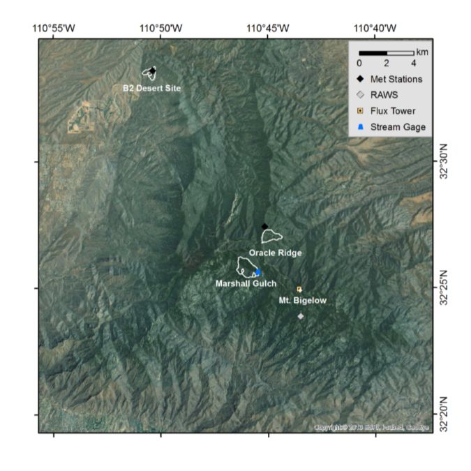
Santa Catalina Mountains Instrumentation Map
-
-
Dynamic Map
To fully zoom into a small area, you may need to visit the "Map" button and uncheck "Terrain" view.
-
Data
Catalina-Jemez - GIS/Map Data (2010-2014)
2 components • Santa Catalina Mountains, Jemez River Basin • GIS / Remote Sensing • Durcik, MatejNational - Climate, Flux Tower, Streamflow / Discharge - CUAHSI WDC web services (1968-2015)
7 components • Boulder Creek Watershed, Christina River Basin, Jemez River Basin, Santa Catalina Mountains, El Verde Field Station, Northeastern Puerto Rico and the Luquillo Mountains, Rio Blanco, Rio Mameyes, Susquehanna Shale Hills Critical Zone Observatory, Providence Creek Headwater Catchments (1660 - 2115 m elevation), Wolverton Basin (2230 - 2700 m elevation), Other instrumented sites • Climatology / Meteorology, Hydrology, Soil Science / Pedology • Boulder Creek Critical Zone Observatory; Catalina-Jemez Critical Zone Observatory; Luquillo Critical Zone Observatory; Shale Hills Critical Zone Observatory; Southern Sierra Critical Zone Observatory; Christina River Basin Critical Zone ObservatoryNational - Streamflow / Discharge - USGS and USDA Data Resources (1985-2017)
22 components • Boulder Creek Watershed, Santa Catalina Mountains, Jemez River Basin, Reynolds Creek Experimental Watershed, Susquehanna Shale Hills Critical Zone Observatory, Northeastern Puerto Rico and the Luquillo Mountains, Clear Creek Watershed, Sangamon River Basin, Calhoun Critical Zone Observatory, Providence Creek Headwater Catchments (1660 - 2115 m elevation) • Hydrology • USGS National Water Information SystemSanta Catalina Mountains - GIS/Map Data - EEMT (2010)
1 components • Santa Catalina Mountains • GIS / Remote Sensing, Biology / Ecology • Rasmussen, Craig; Durcik, MatejSanta Catalina Mountains - Stream Water Chemistry (2006-2018)
11 components • Santa Catalina Mountains • Water Chemistry • Chorover, Jon; Troch, Peter; McIntosh, Jennifer; Brooks, Paul; Abramson, Nate; Heidbuechel, Ingo; Amistadi, Mary Kay; Pedron, Shawn AlexanderSanta Catalina Mountains - Soil Water Chemistry (2006-2018)
11 components • Santa Catalina Mountains • Water Chemistry, Geochemistry / Mineralogy, Soil Science / Pedology • Chorover, Jon; Perdrial, Julia; Troch, Peter; Heidbuechel, Ingo; Abramson, Nate; Amistadi, Mary Kay; Pedron, Shawn AlexanderSanta Catalina Mountains - Precipitation Chemistry (2006-2018)
10 components • Santa Catalina Mountains • Water Chemistry • Chorover, Jon; Troch, Peter; McIntosh, Jennifer; Brooks, Paul; Abramson, Nate; Heidbuechel, Ingo; Amistadi, Mary Kay; Pedron, Shawn AlexanderShale Hills, Boulder, Luquillo, JRB-SCM, Calhoun - Soil Geochemistry (2001-2013)
1 components • Susquehanna Shale Hills Critical Zone Observatory, Bisley, Boulder Creek Watershed, Northeastern Puerto Rico and the Luquillo Mountains, Santa Catalina Mountains • Geochemistry / Mineralogy, Biogeochemistry • Niu, Xianzeng; Williams, Jennifer; Brantley, Susan L.; Miller, Doug; Bills, Brian
-
Climate
10-18 °C Mean Annual Temp 24 °C Mean Warmest Month 6 °C Mean Coldest Month 420-940 mm Mean Annual Precipitation The climate is semiarid across most of the Santa Catalinas, with mean annual precipitation ranging from 330 mm at the mouth of Sabino Canyon to 750 mm on Mount Lemmon. As in the rest of southern Arizona, precipitation in Tucson is generally biseasonal with maxima in winter and summer. About 45% of rainfall falls during the summer monsoon season of July through September, typically in convective storms, and about 34% of precipitation occurs between December and March during less intense storms. The range is located near the eastern limit of the Sonoran desert, within a semi-arid climate. The vegetation varies from southwestern desert shrub at low elevations, to broadleaf woodland chaparral between 1300 and 2200 m, and mixed-coniferous forest at the highest elevations.
Explore Further
