GullyErosionProfiler
1D model of gully longitudinal profile evolution
Calculates the long-profile evolution of a gully channel containing an abrupt step (headcut).
Model Category: Numerical
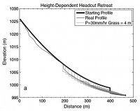
Image: Comparison of the longitudinal profile of a gully on the Colorado eastern plains (thin black line) with several time steps from a modeled profile (gray lines). This model has resistant grassland vegetation everywhere but the 4 m downstream of the headcut (vertical step), variable discharge, and precipitation rate = 35 mm/h. In this version of the model, the rate of headcut retreat depends on its height. Total model time shown is 400 years. Figure 12a from Rengers, F. K., & Tucker, G. E. (2014). Analysis and modeling of gully headcut dynamics, North American high plains. Journal of Geophysical Research: Earth Surface, 119(5), 983-1003
-
Boulder, INVESTIGATOR
Francis Rengers - CU doctoral student 2009-2014
Gullies are dynamic fluvial features that can be the primary driver for landscape dissection and sediment production in many settings. Gully erosion is common across Colorado’s eastern plains, which form the baselevel for catchments draining the eastern flank of the Front Range (including Boulder Creek). This research exploits a well-constrained field area near West Bijou Creek, Colorado, U.S., in order to develop a natural experiment in which we explore gully headcut erosion rates, the controls on gully headcut height, and the morphology of gully longitudinal profiles. Analysis of headcut retreat using aerial photography and airborne lidar imagery indicates that headcut retreat rates correlate with the square root of drainage area approximately. We investigate how a drainage area control on headcut retreat translates into the longitudinal profile morphology over time using a simple numerical model. The model combines fluvial erosion, deposition, and headcut retreat to identify the necessary and sufficient conditions needed to reproduce longitudinal profiles observed in the field. Field profiles are typically concave-upward, predominantly aggradational channel profiles with retreating headcuts whose height varies with catchment position. Systematic variation of environmental parameters in the model showed that the most successful model was achieved when highly resistant vegetation is applied throughout the channel, excluding a bare soil zone downstream of the headcut. This model scenario maintained an abrupt headcut over hundreds of model years and produced a realistic longitudinal profile that aggrades downstream of the headcut over time. The vegetation pattern used in the best model fit is observed at the field site, where easily erodible, sparsely vegetated soil downstream of the headcut grades into a more resistant grassy channel downstream.
Publications
2014
Analysis and modeling of gully headcut dynamics, North American high plains. Rengers, F. K., & Tucker, G. E. (2014): Journal of Geophysical Research: Earth Surface, 119(5), 983-1003.
Explore Further


