ARCHIVED CONTENT: In December 2020, the CZO program was succeeded by the Critical Zone Collaborative Network (CZ Net)
×
Geomorphology & Paleoclimates
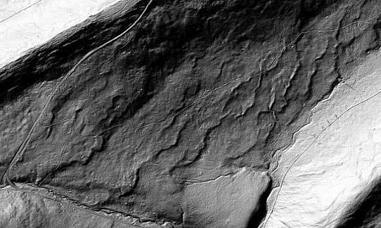
Grayscale image of LiDAR data for a small study area in Pennsylvania about 2 miles long by 1 mile wide. Roads, fields, and wavy ridges are visible.
Use imagery to understand and interpret the effect of geologic processes on a landscape and to relate the processes to past climatic conditions. Become familiar with remote sensing data using imagery from Google Earth and HiRISE for Mars as well as LiDAR data.
Grades 9 -
12
Geomorphology • GIS/RemoteSensing
Activity
Educational Objectives
- Use landscape imagery to explain and interpret the effect of geologic processes on a landscape and to relate the processes to past climatic conditions.
- Describe the technology known as Light Detection and Ranging (LiDAR) and some ways that LiDAR data is used to study landscapes and environmental change.
Audience
K-12
Observatory: Shale Hills CZO
Author(s): Tim White (Penn State), Ashlee Dere (University of Nebraska-Omaha), Sarah Sharkey (Penn State)


Funding: NSF CZO
Explore Further
